Transport in Barbados
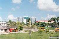
Barbados is an up-and-coming tourist country that provides reliable and safe transportation for natives and visitors alike. The country is very small with a length of 21 miles (34 km) long and 14 miles (23 km) wide.[1] Barbados has 1,600 kilometres (990 mi) of public paved roads, two active marine ports in (Bridgetown Port and Port Saint Charles), remnants of a railway system, and one airport; the Sir Grantley Adams International Airport, located in Christ Church.
Roadways
As a former British colony, Barbados was heavily influenced by the English culture and customs which carried over into the infrastructure of Barbados. Similar to the driving habits in the United Kingdom, people in Barbados also drive on the left side of the road. Barbados has a very dependable highway system of main roads that stem from the country's capital, Bridgetown. The highways are identified by the numbers one to seven. H1 signifies the first highway that runs north. The numbering continues sequentially in a clockwise direction. The most popular highway throughout the island is the A. B. C. Highway (Adams/Barrow/Cummins).
Throughout the Barbados roadways, the most prominent traffic junctions are the two lane roundabouts. Like roundabouts seen in the United States vehicles in the inner most lane of the roundabout have the right of way, however, in Barbados the traffic moves in clockwise direction. The speed limit on all roads is 60 km/h (37 mph) unless otherwise posted. The speed limit on the ABC Highway and the Spring Garden Highway is 80 km/h (50 mph).
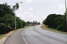
In 2010, an assessment released by the Economist Intelligence Unit (EIU) of the United Kingdom, ranked Barbados 6th in the world, and the top spot in the Western Hemisphere for road network density.[2]
Road incidents
In terms of traffic and accidents, the 2010 EIU report found that Barbados had 63.1 vehicles for every 1 km of road on the island.[2] A rank that placed Barbados as 23rd globally for amount of vehicles, by the total surface area of roads. For accident totals, Barbados placed 12th globally for road victims per 100,000 people; and 23rd globally (which was shared with The United States, Greece, Tunisia, Estonia and Georgia), for actual road fatalities per 100,000 people.
Public transport
The Ministry of Transport & Works of Barbados oversees the affairs of the nation's roads, highways, and the public transport system. Public transport services in Barbados include buses, taxis, share taxis (Called "ZRs"), and car rentals. Some services run on a direct route to their destinations however, most public transport services require a connection through Bridgetown.
ZR Vans
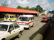
The ZRs (pronounced "Zed-Rs"), are privately owned mini-vans that run on specific predetermined routes. They are recognized by their white exterior and maroon stripe down the side. ZRs are independently owned but have a fixed fare of two dollars per person for one way. According to travel agencies, ZRs are not only the most reliable form of public transportation, but they also provide entertainment to its customers. ZRs move quickly and stop frequently to pick up the maximum number of paying passengers in the shortest amount of time. Therefore, ZRs have a reputation for loud music and cramped spacing.
Taxis
Taxi services are also available to natives and guests of the island. Taxis, similarly to the United States, provide transportation at a predetermined government rate.
Bus service
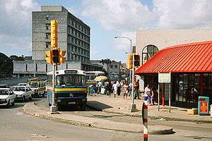
The bus services in Barbados are also a mode of transportation that are available to all, however, natives are the predominant group that use the public buses. The Barbados Transport Board is a government organization that is responsible for bus transportation. The board started as an organization on 24 August 1955 and has operated ever since. There are currently two hundred buses in use around the island. There are two types of buses, large blue buses and yellow buses. The usually larger blue buses, are government-operated by the Barbados Transport Board and charge the same fee as the other services ($2.00 BDS). Adults have to pay the fee, but the public bus is free for all children in school uniforms, students with an institution ID that are under the age of eighteen and senior citizens. Unlike other transportation, Public government buses run on an exact fare system and are unable to give change.
There are also privately operated Minibuses that are yellow with a blue stripe. They operate mainly on the west and south coastline. The most popular routes are Bridgetown–Speightstown and Bridgetown–Sam Lord's Castle. They charge $2.00 and are able to give change.[3]
Car rental
Car rental in Barbados is provided through any of several vehicle rental agencies. They offer a wide variety of vehicles from luxury cars to vans, and also smaller open top cars. Foreign drivers driving in Barbados require a temporary driver's licence in addition to an international licence.
Railway

A proposal for a railway system in Barbados was first made in 1845 by Britain. It was not until 1881 that construction began on the new 3 ft 6 in (1,067 mm) narrow gauge Barbados Railway by an independent country for the purpose of transporting sugar cane across the island to the seaport of Bridgetown. A brief history is here:[4]
It was later converted to 2 ft 6 in (762 mm) narrow gauge by Everard Calthrop.
From the early 20th century on, the railway system carried produce to and from factories to the city and also passengers to and from the city. However, complications arose. There was a lack of funding for the maintenance and upkeep of the system. Also, the poor designs of the tracks and cars posed a challenge against the high tides of the Atlantic Ocean. To keep the railway in use, the government of Barbados took over in 1916 however it continued to decay. By 1937 the railway was shut down due to safety issues.
There are still remnants of the railway today and many can be seen by the coastlines. And every year there is a marathon run & walk along the old route from Bridgetown to Carrington on the East Coast; see:.[5]
In 1881 a horse-drawn tramway, the Barbados Tramway Company, was constructed around Bridgetown by the Scottish railway engineer Robert Fairlie and ceased operations in 1925.[6]
Waterways
Barbados also provides ports for large cruise ships and transportation of goods into and out of the country. The main ports reside in Bridgetown, Saint Michael (Deep Water Harbour), and in Speightstown, St. Peter (the Port Charles Marina). These are regulated by the Barbados Port Authority. Large cruise ships dock at the Deep Water Harbour at the southwestern end of the island.
Boating
Boating to and from Barbados requires following all International and local laws. If arriving in Barbados it is important to remember that legally you must enter an approved port of entry, which means stopping by the Harbour-master first at Bridgetown. Laws also protect the coral reefs, and boaters should be careful not to drop anchor outside of areas approved by the government of Barbados in order to protect the corals and possibly other undersea infrastructure that might be present around the island.
Barbados currently no longer has the Schooner vessel that once operated between Speightstown and Bridgetown. However, in recent years, with many heavy traffic problems on the island, there have been calls to revive it.
References
Notes
- ↑ Transportation at Totally Barbados
- 1 2 Best, Tony (4 Jan 2010). "Barbados' road networks among the most crowded in the world". Nation Newspaper. Retrieved 4 January 2010.
Barbados has one of the world's most dense road networks, leading the Western Hemisphere with 3.7 kilometres of road for every kilometre of land, reported the EIU, giving it a global ranking of sixth, behind Macau, Malta, Bahrain, Singapore and Belgium. Not far away were Puerto Rico, 2.8 km (2 mi) and 9th; Jamaica 2.0 km (1 mi) and 10th; and Trinidad and Tobago 19th with 1.6 km (1 mi) of road.
- ↑ "Barbados Minibus Guide". Minibus web page. Retrieved 24 November 2014.
- ↑ The History of the Barbados Railway
- ↑ Great Train Run
- ↑ The Tramways of Bridgetown Barbados
- Much of the material in this article is adapted from the CIA World Factbook 2000.
Further reading
- Horsford, Jim (2001). From the Caribbean to the Atlantic : a brief history of the Barbados Railway. Alcester, Warwickshire: Paul Catchpole. ISBN 1900340127.
External links
| Wikimedia Commons has media related to Transport in Barbados. |
- http://www.mtw.gov.bb/ - Ministry of Transport and Works
- http://www.ta.gov.bb/ - The Transport Authority
- http://www.transportboard.com/ - The Public transport provider of the Barbados Gov't
- http://www.barbadosmaritime.com/ - The Barbados Maritime Ship Registry (BMSR)
- Barbados Transportation
- Barbados Ship Registrar, Ukraine
- The Tramways of Barbados: historical survey with map and 16 illustrations
- http://barbadospocketguide.com/our-island-barbados/history-of-barbados.html
Transport in the Americas | ||
|---|---|---|
| ||
| Sovereign states |
| .svg.png) |
| ||