Transfer Station (Hudson County)
Transfer Station is the name of a section of Hudson County, New Jersey, which radiates from the intersection where Paterson Plank Road crosses Summit Avenue at 7th Street, and where the borders of Jersey City Heights, North Bergen, and Union City meet at one point, which is a few blocks to the southwest of the station, at the intersection of Secaucus Road and Kennedy Boulevard.[1][2]
The section lies west of Washington Park, a Hudson Park, along the shared city line of Jersey City and Union City running diagonal across the urban grid. It lies just to the northeast of Chelsea in Jersey City. Here Kennedy Boulevard curves eastward following the contour of the Hudson Palisades. Secaucus Road, which creates part of the city line, begins in the district, and descends the Western Slope where North Bergen begins.
Transfer Station takes its name from a former North Hudson Railway, and later Public Service Railway streetcar interchange. Routes that crossed the area were the 15 Passaic, 17 Summit, 29 Hudson, and 35 Secaucus It is a busy commercial district and transportation hub that was the 'downtown' of West Hoboken before its merger with Union Hill, resulting in the creation of Union City in 1925.After the 1950s Transfer Station became somewhat of a red light district, filled with many taverns, nightclubs, discos, go-go bars, and 24-hour diners. The bars and night clubs where there because Union City was the only town in the area that allowed women in the bar room in those days. The other towns had separate family rooms and entrances for women. Frankie Valli and the four seasons where very popular at Molinari's in their early years. Though some pubs remain, the area is essentially a local commercial/shopping area interspersed with residences.
Transportation
New Jersey Transit bus routes 82, 83, 85, and 88 serve the district.
References
- ↑ Hudson County New Jersey Street Map. Hagstrom Map Company, Inc. 2008. ISBN 0-88097-763-9.
- ↑ Schwartz, Art (March 16, 2014). "Jersey diner served GI’s when things were 'wild'". The Hudson Reporter.
Coordinates: 40°45′29″N 74°2′38″W / 40.75806°N 74.04389°W
| Bergen-Lafayette |  | |
|---|---|---|
| Downtown | ||
| Greenville | ||
| The Heights | ||
| Journal Square | ||
| Meadowlands | ||
| Upper New York Bay | ||
| West Side | ||
| Historical | ||
Municipalities and communities of Hudson County, New Jersey, United States | ||
|---|---|---|
| Cities | 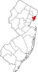 | |
| Borough | ||
| Towns | ||
| Townships | ||