Tramways in Île-de-France
 | |||
|
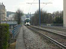
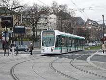
Tram on line T2 in Issy-les-Moulineaux | |||
| Overview | |||
|---|---|---|---|
| Native name | Tramways d'Île-de-France | ||
| Locale | Paris, Île-de-France, France | ||
| Transit type | Light rail tram | ||
| Number of lines | 9 | ||
| Number of stations | 186[1][2] | ||
| Operation | |||
| Began operation | 1992 | ||
| Operator(s) | RATP / SNCF | ||
| Technical | |||
| System length | 104.7 km (65.1 mi)[1][2][3] | ||
| Track gauge | 1,435 mm (4 ft 8 1⁄2 in) standard gauge for conventional lines | ||
| |||

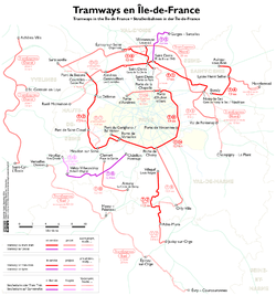
The Île-de-France tramways (French: Tramways d'Île-de-France) consists of a network of modern tram lines in the Île-de-France region of France. Nine lines are currently operational (counting Lines 3a and 3b as separate lines), with extensions and additional lines in the planning and construction stage.
Although the system mainly runs in the suburban regions of Paris, lines T3a and T3b run entirely within Paris city limits, and line T2 also does so for part of its route. While the lines operate independently of each other and are generally unconnected, some connections do exist: between lines T2 and T3a, T3a and T3b, T1 and T5 (opened in 2013) and T1 and T8 (opened in 2014). However, the final design of the entire planned tram network is fairly integrated.
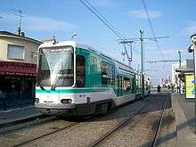
Almost all lines are operated by the Régie Autonome des Transports Parisiens (RATP), which also operates the Paris Métro and most bus services in the Paris area. Furthermore, while most lines use conventional steel-wheel rolling stock, two lines (T5 and T6) use rubber-tired trams. Moreover, line T4, which uses tram-train technology, is operated by the French national rail operator SNCF as part of its Transilien regional rail network.
History
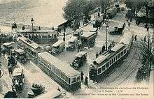
From 1855 to 1938, Paris was served by an extensive tramway network, predating the metro by nearly a half-century.[4] In 1925 the network had a 1111 km length, with 122 lines. In the 1930s, the oil and automobile industry lobbies put pressure on the Paris Police Prefecture to remove tram tracks to make room for cars.[5] The last of these first generation tram lines in Paris, Porte de Saint-Cloud to Porte de Vincennes, was closed in 1937,[6] and the last line in the entire Paris agglomeration, running between Le Raincy and Montfermeil, ended its service on 14 August 1938.[5]
Originally horse-powered, Paris trams used steam, and later pneumatic engines, then electricity.
The funicular that operated in Belleville from 1891 to 1924 is sometimes erroneously thought of as a tramway, but was actually a cable car system.
The first of a new generation of trams in Paris, line T1 opened in 1992, with line T2 opening in 1997, line T4 on 18 November 2006, and line T3 on 16 December 2006. The newest lines, T5 and T7, opened on 29 July 2013 and 16 November 2013, respectively.
Lines
| Line | Opening[7] | Length | Stations | Operator |
|---|---|---|---|---|
| |
1992[8] | 17 km (11 mi) | 36 | RATP |
| |
1997[8] | 17.9 km (11.1 mi) | 24 | RATP |
| |
2006[8] | 12.2 km (7.6 mi) | 25 | RATP |
| |
2012[8] | 9.9 km (6.2 mi) | 18 | RATP |
| |
2006[2] | 8 km (5.0 mi)[2] | 11[2] | SNCF |
| |
2013[8] | 6.6 km (4.1 mi)[8] | 16[8] | RATP |
| |
2014[3] | 14 km (8.7 mi)[3] | 21[3] | RATP |
| |
2013[8] | 11.2 km (7.0 mi)[8] | 18[8] | RATP |
| |
2014[3][9] | 8.5 km (5.3 mi)[3][9] | 17[3][9] | RATP |
| TOTAL: | 104.7 km (65.1 mi)[1][2][3] | 186[1][2][3] | ||
T1
Line T1 connects Saint-Denis to Noisy-le-Sec, parallel to the Paris northern city limit. It opened in 1992, and the extension to Noisy-le-Sec was completed in December 2003. An extension west to Asnières and Gennevilliers opened in November 2012, and a continuation to Nanterre is planned. An eastwards extension to Montreuil and to the Val de Fontenay RER station is planned and expected to be open in 2017.
T2
Line T2 (Trans Val-de-Seine) connects Pont de Bezons with Porte de Versailles via La Défense. It opened in 1997 between La Défense and Issy Val-de-Seine, mostly on converted SNCF right-of-way. An extension from Issy Val-de-Seine to Porte de Versailles opened in 2009 and a second extension from La Défense to Pont de Bezons opened in 2012.
T3a and T3b
Line T3 is the first modern tramway in Paris proper. It is divided into two sections called T3a and T3b. The line is also known as the tramway des Maréchaux because it follows the boulevards des maréchaux, a series of boulevards that encircle Paris along the route of the former Thiers Wall (built 1841–44). The boulevards are, with three exceptions, named for Napoleon's First Empire marshals (maréchaux).
T3a connects Boulevard Victor – Pont du Garigliano RER station in the western part of the 15th arrondissement with Porte de Vincennes metro station in the 12th arrondissement.
T3b connects Porte de Vincennes with Porte de la Chapelle in the 18th arrondissement. T3b should be extended to Porte d'Asnières in 2017.
T4
Line T4 is an 8-kilometre (5.0 mi), 11-stop[2] tram-train line, operating in part on SNCF lines, connecting Bondy RER station with Aulnay-sous-Bois station. It opened on November 18, 2006. Unlike the other tramways in Île-de-France, T4 is operated by SNCF. A new branch of this tram-train line will be opened in 2017.
T5

Tramway T5[10] runs on tyres (i.e. Translohr)[11] along a mainly segregated "track" on the busy Route Nationale 1 (similar to the systems in Nancy or Caen), replacing the often busy bus lines 168 and 268. The 6.6-kilometre (4.1 mi) route[11] serves 16 stops[11] between Saint-Denis, Pierrefitte-sur-Seine, Sarcelles and Garges-lès-Gonesse. It has an interchange with T1 at its southerly terminus marché de Saint-Denis and with RER D at Garges-Sarcelles.[12] Line T5 opened in July 2013.[13]
T6
A 14-kilometre (8.7 mi) route on tires (with 1.6 kilometres (0.99 mi) in tunnel) serving 21 stations (including 2 underground), going from Châtillon - Montrouge (terminus of metro ligne 13) to Viroflay - Rive Droite (Transilien railway station). The majority of the line opened in 2014, with the balance opening in 2016.
T7
An 11.2-kilometre (7.0 mi) route serving 18 stations[8] between Villejuif (terminus of Paris Métro Line 7) serving Rungis and Orly and terminating at Athis-Mons opened on 16 November 2013.[14] The line will be extended in 2018 to Juvisy-sur-Orge.
T8
Formerly to be known as "Tram'y", this 8.46-kilometre (5.26 mi) line goes from Saint-Denis (Porte de Paris) to Épinay-sur-Seine (Quartier d'Orgemont), with a branch to Villetaneuse. Villetaneuse is also planned to be a future station on the new Tangental North line. An extension is also planned to the RER E station at Rosa Parks. Construction began in 2010, and services began in 2014.[14]
Planned lines
Several new lines of tramway and trams on tires have been planned in the region and on 11 February 2009 every project was re-assessed and given a "T" number by the STIF (the regional transport council of the Île-de-France). Posters began to appear in the metro from April 2009 promoting the entire 8‑route T system. In 2020 with all the new tram lines and extension planned the tram network will be 152 kilometres (94 mi) long.
T9
Planned line between Paris Porte de Choisy and the city of Orly, expected in 2020.
T10
Planned line from Antony to Clamart in the southwest suburbs of Paris, expected in 2021.
TVM
The Trans-Val-de-Marne bus line, which runs in a designated bus lane and is intended to provide rapid transit southeast of Paris in the département of Val-de-Marne, is operated by RATP. Despite beginning with a T, it is not a part of the tramway network.
See also
- Transportation in Paris
- Trams in France
- List of town tramway systems in France
- List of tram and light rail transit systems
References
- 1 2 3 4 "RATP's tram network in Île-de-France". RATP. Archived from the original on 2014-04-26. Retrieved 2014-04-25.
- 1 2 3 4 5 6 7 8 "BIENVENUE SUR LA LIGNE T4" [WELCOME TO THE T4 LINE]. sncf.com (in French). SNCF Transilien. 2013. Retrieved 2013-09-13.
- 1 2 3 4 5 6 7 8 9 "2014, the next year of the tram". RATP. Retrieved 2014-12-16.
- ↑ LE CHEVAL A PARIS DE 1850 a 1914 (in French). Librairie Droz. pp. 84ff. ISBN 978-2-600-04536-0.
- 1 2 Dominique Larroque; Michel Margairaz; Pierre Zembri; Association pour l'histoire des chemins de fer en France (2002). Paris et ses transports: XIXe-XXe siècles, deux siècles de décisions pour la ville et sa région. Recherches. p. 131. ISBN 978-2-86222-042-0.
- ↑ Ralf Roth; Colin Divall (28 March 2015). From Rail to Road and Back Again?: A Century of Transport Competition and Interdependency. Ashgate Publishing, Ltd. pp. 351ff. ISBN 978-1-4094-7115-8.
- ↑ "RATP's tram network in Île-de-France". RATP. Retrieved 2014-12-16.
- 1 2 3 4 5 6 7 8 9 10 11 "2013, another year of the tram". RATP. Retrieved 2014-12-16.
- 1 2 3 "Paris opens tram Route T8". Railway Gazette International. 16 December 2014. Retrieved 2014-12-16.
- ↑ "Tramway 5 - le T5 en ligne" [Tramway 5 - The T5 line] (in French). RATP. Retrieved 2013-09-13.
- 1 2 3 "le T5 en ligne - Le projet - L'essentiel" [The T5 line - the project - essentials] (in French). RATP. Retrieved 2013-09-13.
- ↑ http://www.anous.fr/paris/traffic/un-nouveau-tram-en-banlieue/3897.html[]
- ↑ "Home - In Ile-de-France - Extending the network - Tramway - Créations : T5". Retrieved 2013-09-12.
- 1 2 "Citadis remains popular in Paris". Railway Gazette International. 28 January 2011. Retrieved 2014-07-12.
External links
| Wikimedia Commons has media related to Trams in Paris. |
- Tram line routes at the RATP official website
- T3 official website
- RATP official extension information
- Comprehensive map of the Paris tramways network (French)
 | ||
| |
| |
| |
| Related articles | |