Trams in Luxembourg
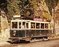
Trams in Luxembourg started operation in 1875 when the first horse trams ran in Luxembourg City along a 10 km line. Electrification followed in 1908. The original track followed a route from the central station through the city centre to Limpertsberg. It was extended to various parts of the city until 1930 when the network covered 31 km. Several lines were closed at the beginning of the 1960s as buses replaced the trams. The last tram ran on the line to Beggen on 5 September 1964.[1]
The country's other tram network designated Tramways Intercommunaux du Canton d'Esch served Esch-sur-Alzette and surroundings from 1927 to 1956.[2]
Future plans
Luxembourg is planning to reintroduce trams in the near future, initially from the central station to Kirchberg and then to Luxembourg Airport.[3]
On 10 March 2009, Guy Besch, president of LuxTram, announced that design work on the tramway project had been awarded to the British firm Lifschutz Davidson Sandilands, the winner of an open competition.[4] Work is expected to be completed by 2017 at a total cost of EUR 400 million, including rolling stock. Among other things, it will necessitate considerable redesign work on the Pont Adolphe at the centre of the city.[5] Lucien Lux, Minister of Transport, explained that the initial phase would run from Kirchberg to the Central Station. It would then be extended to the station in Hollerich. Funding was to be shared between the City of Luxembourg and the State.[6]
In June 2014, the Chamber of Deputies approved by a 56–3 vote the project to build the tramway.[7]
Luxembourg's tram and bus museum
A number of historic trams can be seen at Luxembourg City's tram and bus museum located on Rue de Bouillon in Hollerich. In particular, the museum exhibits two electric trams, two tram coaches, and a replica of a horse tram. There are also numerous models and photographs.[8]
Virtual tram-train

There is an other tramline (tram-train - It runs underground a lot) for Luxembourg City (named: Luxembourg T2 - it signed with green color in the map), which connects the western area of Luxembourg City with Gare Dommeldange and with the centre. The line meets with Luxembourg T1 (planned by luxtram.lu - it signed with purple color in the map) at Place de l'Étoile and Gare Pont Rouge stops. This line also runs on the CFL track between Gare Pont Rouge and Gare Dommeldange stops. The virtual route can be played under openBVE railroad simulator, and it can be downloaded from bveroli.atw.hu webpage (under Downloads menu).
Bibliography
- Association des modélistes ferroviaires de Luxembourg (Walferdange): Les tramways de la ville de Luxembourg: T.V.L., Walferdange : A.M.F.L., 1986, 156p., Collection: Les chemins de fer luxembourgeois, Vol. 5.
- Bohnert, Paul; Dhur, Raymond; Eck, Jules; Rauen, Prosper: De Minettstram: die Geschichte der interkommunalen Trambahnen im Kanton Esch, Düdelingen : Stadtverwaltung und Kulturkommission, 1985, 325p.
- Hoffmann Jean-Paul, Dhur Raymond, Clesse René, Balthasar Marcel: Tramway Municipaux - De Stater Tram: die Geschichte des öffentlichen Personen-Nahverkehrs in der Stadt Luxemburg 1875-1993, Administration municipale, 1993, 259p.
See also
References
- ↑ The Tramways of the City of Luxembourg. Retrieved 3 March 2009.
- ↑ The Tramways of the Canton d'Esch. Retrieved 3 March 2009.
- ↑ Mobil 2020. From Ministère des Transports, Luxembourg. Retrieved 2 March 2009.
- ↑ LuxTram contractor announced. Retrieved 11 March 2009.
- ↑ Tram à Luxembourg: un projet imaginé à Londres. Point24. Retrieved 11 March 2009.
- ↑ "Ce projet, c'est l'esprit LuxTram". Lucien Lux sur le vainqueur du concours LuxTram. Luxembourg government. Retrieved 11 March 2009.
- ↑ 6626 - Projet de loi portant sur la construction d'une ligne de tramway à Luxembourg entre la Gare Centrale et le Circuit de la Foire Internationale au Kirchberg, Chamber of Deputies
- ↑ Tramways and Bus Museum of the City of Luxembourg. Retrieved 3 March 2009.