Tröllaskagi

Tröllaskagi is a peninsula in northern Iceland between the fjords of Eyjafjörður and Skagafjörður. The peninsula is mountainous with several peaks reaching over 1000 meters above sea level, the tallest is Kerling (1538 m). It is the part of Iceland with the highest elevation outside the central highlands.
The peninsula is cut by several deep valleys that were carved by glaciers during the glacial periods of the last Ice age and later by the rivers that now flow down those valleys. A few permanent glacier ice caps still exist in central Tröllaskagi but they are all rather small.
Human settlement is only extant in the relatively flat lowlands along the coast and in the valleys but these lowlands are densely populated by Icelandic standards with important agricultural regions and a few towns and villages that mostly base their livelihood on fisheries. Those settlements are (clockwise around the peninsula beginning in Skagafjörður): Hofsós, Hólar, Siglufjörður, Ólafsfjörður, Dalvík, Árskógssandur, Hauganes, Hjalteyri, Hrafnagil and the largest being Akureyri.
Öxnadalsheiði
The Ring Road runs through Tröllaskagi between Siglufjörður and Eyjafjörður through a mountain pass called Öxnadalsheiði where the road reaches a maximum elevation of 540 meters above sea level which can sometimes pose a problem during wintertime. Several different tunneling projects have been suggested as a way to bypass Öxnadalsheiði.
-
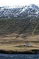
Abandoned farmstead in Öxnadalsheiði, November 2007
-

Leaving Öxnadalsheiði, entering Öxnadalur
-
_along_the_north_slope_of_%C3%96xnadalur_II.jpg)
Panorama of the ridge (1188m) along the north slope of Öxnadalur
Coordinates: 65°56′59″N 18°54′25″W / 65.94972°N 18.90694°W