Economy of Svalbard

The economy of Svalbard is dominated by coal mining, tourism and research. In 2007, there were 484 people working in the mining sector, 211 people working in the tourism sector and 111 people working in the education sector. The same year, mining gave a revenue of NOK 2.008 billion, tourism NOK 317 million and research 142 million.[1] In 2006, the average income for economically active people was NOK 494,700, or 23% higher than on the mainland.[2] Almost all housing is owned by the various employers and institutions and rented to their employees; there are only a few privately owned houses, most of which are recreational cabins. Because of this, it is nearly impossible to live on Svalbard without working for an established institution.[3] The Spitsbergen Treaty and Svalbard Act established Svalbard as an economic free zone and demilitarized zone in 1925.[4]
Taxation
The Spitsbergen Treaty of 1920 established full Norwegian sovereignty over the archipelago. The islands are, unlike the Norwegian Antarctic Territory, part of the Kingdom of Norway and not a dependency. The treaty came into effect in 1925, following the Svalbard Act. All forty signatory countries of the treaty have the right to conduct commercial activities on the archipelago without discrimination, although all activity is subject to Norwegian legislation. The treaty limits Norway's right to collect taxes to that of providing services on Svalbard. Therefore, Svalbard has a lower income tax than mainland Norway, and there is no value added tax. There is a separate budget for Svalbard to ensure compliance. Svalbard is a demilitarized zone, as the treaty prohibits the establishment of military installations. Norwegian military activity is limited to fisheries surveillance by the Norwegian Coast Guard. The treaty requires Norway to protect the natural environment.[5][6]
Mining
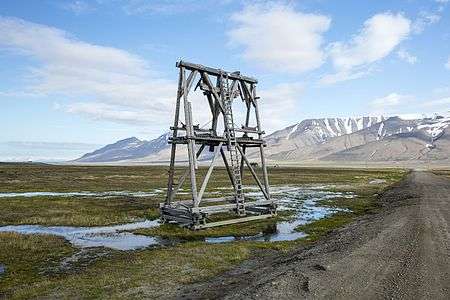
Old cable tower from Adventdalen to Longyearbyen
Since the resettlement of Svalbard in the early 20th century, coal mining has been the dominant commercial activity. Store Norske Spitsbergen Kulkompani, a subsidiary of the Norwegian Ministry of Trade and Industry, operates Svea Nord in Sveagruva and Mine 7 in Longyearbyen. The former produced 3.4 million tonnes in 2008, while the latter uses 35% of its output to power the power station in Longyearbyen. Since 2007, there has not been any significant mining by the Russian state-owned Arktikugol in Barentsburg. There have previously been performed test drilling for petroleum on land, but these did not give satisfactory results for permanent operation. The Norwegian authorities do not allow offshore petroleum activities for environmental reasons, and the land formerly test-drilled on has been protected as natural reserves or national parks.[1]
Fishing and hunting
_5.jpg)
Svalbard has historically been a base for both whaling and fishing. Norway claimed a 200 nautical miles (370 km; 230 mi) exclusive economic zone (EEZ) around Svalbard in 1977,[7] with 31,688 square kilometres (12,235 sq mi) of internal waters and 770,565 square kilometres (297,517 sq mi) of EEZ.[8] Norway retains a restrictive fisheries policy in the zone,[7] and the claims are disputed by Russia.[9]
Tourism
Tourism is centered on Longyearbyen. Activities include hiking, kayaking, walks through glacier caves and snow-scooter and dog-sled safari. Cruise ships generate a significant portion of the traffic, including both stops by offshore vessels and expeditionary cruises starting and ending in Svalbard. Traffic is strongly concentrated between March and August; overnights have quintupled from 1991 to 2008, when there were 93,000 guest-nights.[1]
The world's northernmost blues festival, Dark Season Blues, is an annual event in late October in Longyearbyen, and marks the beginning of the dark season when daylight and the sun is about to leave Svalbard for four long winter months.
Norway announced in February 2012 that, in order to protect the islands from the danger of a ship running aground and possibly causing an oil spill within a pristine fjord, it would implement a requirement for cruise ships to carry a licensed pilot in order for the ship to enter any of the islands' fjords. Many of the fjords on Svalbard are quite dangerous, with strong torrents and narrow fairways. The pilot requirement will be phased-in gradually. Starting in 2012, all vessels going to the Svea coal mine had to carry a pilot. Starting in 2013, all passenger vessels over 150 meters had to have a pilot when going into one of the fjords on Svalbard. And starting in 2014, all boats over 70 meters and all passenger vessels longer than 24 meters needed to have a pilot when entering one of the fjords.[10]
Research
Research on Svalbard centers on Longyearbyen and Ny-Ålesund, the most accessible areas in the high Arctic. Norway grants permission for any nation to conduct research on Svalbard, resulting in the Polish Polar Station and the Chinese Arctic Yellow River Station.[11] The University Centre in Svalbard (UNIS) in Longyearbyen was established in 1993 and offers undergraduate, graduate and postgraduate courses to 350 students.[12] The Svalbard Global Seed Vault is a "doomsday" seedbank to store seeds from as many of the world's crop varieties and their botanical wild relatives as possible. A cooperation between the Government of Norway and the Global Crop Diversity Trust, the vault is cut into rock near Longyearbyen, keeping it at a natural −6 °C (21 °F) and refrigerating the seeds to −18 °C (0 °F).[13][14] The Svalbard Undersea Cable System is a 1,440 km (890 mi) fibre optic lines from Svalbard to Harstad, needed for communicating with polar orbiting satellite stations on Svalbard.[15][16]
Transport
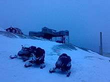
Within Longyearbyen there is a road system, but it does not connect with any other settlements. The town does have a bus system, Off-road motorized transport is prohibited on bare ground, but snowmobiles are used extensively during winter—both for commercial and recreational activities. Transport from Longyearbyen to Barentsburg (45 km or 28 mi) and Pyramiden (100 km or 62 mi) is possible by snowmobile by winter, or by ship all year round.[17]
Svalbard Airport, Longyear, located 3 kilometres (2 mi) from Longyearbyen, is the only airport offering air transport off the archipelago. Scandinavian Airlines has daily scheduled services to Tromsø and Oslo; there are also irregular charter services to Russia.[18] Lufttransport provides regular corporate charter services from Longyearbyen to Ny-Ålesund Airport and Svea Airport for Kings Bay and Store Norske.[19] There are heliports in Barentsburg and Pyramiden, and helicopters are frequently used by the governor and to a lesser extent Arktikugol.[20]
References
- 1 2 3 "9 Næringsvirksomhet". St.meld. nr. 22 (2008–2009): Svalbard. Norwegian Ministry of Justice and the Police. 17 April 2009. Retrieved 24 March 2010.
- ↑ "Focus on Svalbard". Statistics Norway. Retrieved 24 March 2010.
- ↑ "Entry and residence". Governor of Svalbard. Retrieved 24 March 2010.
- ↑ Arlov (1996): 319
- ↑ "Svalbard Treaty". Governor of Svalbard. Retrieved 24 March 2010.
- ↑ "Svalbard Treaty". Wikisource. 9 February 1920. Retrieved 24 March 2010.
- 1 2 "7 Industrial, mining and commercial activities". Report No. 9 to the Storting (1999–2000): Svalbard. Norwegian Ministry of Justice and the Police. 29 October 1999. Retrieved 24 March 2010.
- ↑ "Oversikt over geografiske forhold". Statistics Norway. 2009. Retrieved 24 March 2010.
- ↑ "Svalbard". World Fact Book. Central Intelligence Agency. 15 January 2010. Retrieved 24 March 2010.
- ↑ BarentsObserver.com, 21 February 2012; "No more pilot-free sailing around Svalbard"; accessed 25 FEB 2012.
- ↑ "8 Research and higher education". Report No. 9 to the Storting (1999–2000): Svalbard. Norwegian Ministry of Justice and the Police. 29 October 1999. Retrieved 24 March 2010.
- ↑ "Arctic science for global challenges". University Centre in Svalbard. Retrieved 24 March 2010.
- ↑ "Norway Reveals Design of 'Doomsday' Seed Vault". Nature. 445 (7129): 693. 15 February 2007. doi:10.1038/445693a.
- ↑ "Life in the cold store". BBC News. 26 February 2008. Retrieved 24 March 2010.
- ↑ Gjesteland, Eirik (2004). "Technical solution and implementation of the Svalbard fibre cable" (PDF). Telektronic (3). Retrieved 24 March 2010.
- ↑ Skår, Rolf (2004). "Why and how Svalbard got the fibre" (PDF). Telektronic (3). Retrieved 24 March 2010.
- ↑ Umbriet (1997): 63–67
- ↑ "Direkteruter" (in Norwegian). Avinor. Retrieved 9 September 2009.
- ↑ "Charterflygning" (in Norwegian). Lufttransport. Retrieved 9 September 2009.
- ↑ "11 Sjø og luft – transport, sikkerhet, redning og beredskap". St.meld. nr. 22 (2008–2009): Svalbard. Norwegian Ministry of Justice and the Police. 17 April 2009. Retrieved 24 March 2010.
Bibliography
- Arlov, Thor B. (1996). Svalbards historie (in Norwegian). Oslo: Aschehoug. ISBN 82-03-22171-8.
- Umbreit, Andreas (2005). Guide to Spitsbergen. Bucks: Bradt. ISBN 1-84162-092-0.