Totes Gebirge
| Totes Gebirge | |
|---|---|
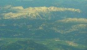 Aerial photo of Totes Gebirge | |
| Highest point | |
| Peak | Großer Priel |
| Elevation | 2,515 m (8,251 ft) |
| Coordinates | 47°43′1″N 14°3′48″E / 47.71694°N 14.06333°ECoordinates: 47°43′1″N 14°3′48″E / 47.71694°N 14.06333°E |
| Geography | |
.png) Totes Gebirge (in red) within the Alps. | |
| Country | Austria |
| States | Styria and Upper Austria |
| Parent range | Northern Limestone Alps |
The Totes Gebirge is a group of mountains in Austria, part of the Northern Limestone Alps, lying between the Salzkammergut and the Ennstaler Alpen. The name Totes Gebirge is derived from the German words tot meaning "dead", referring to the apparent lack of vegetation, and Gebirge meaning "mountain range". The area is a large karst plateau with steep sides, and several mountain peaks above 2000 m. The highest point is the summit of Großer Priel, at 2,515 metres (8,251 ft)
See also

This article is issued from Wikipedia - version of the 11/4/2016. The text is available under the Creative Commons Attribution/Share Alike but additional terms may apply for the media files.