Torringford Street Historic District
|
Torringford Street Historic District | |
 | |
  | |
| Location | Torringford St. from Main St. N to W. Hill Rd., Torrington, Connecticut |
|---|---|
| Coordinates | 41°50′45″N 73°4′27″W / 41.84583°N 73.07417°WCoordinates: 41°50′45″N 73°4′27″W / 41.84583°N 73.07417°W |
| Area | 650 acres (260 ha) |
| Built | 1732 |
| Architectural style | Colonial Revival, Colonial, Federal |
| NRHP Reference # | [1] |
| Added to NRHP | July 31, 1991 |
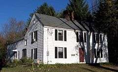
The Torringford Street Historic District is a historic district on the east side of the city of Torrington, Connecticut. The district includes properties along Torringford Street (Route 183), the main thoroughfare of the Torringford section of the city. The road is one of the oldest in Torrington, and this section is notable for containing a cross-section of well-preserved architecture from the 18th to the mid-20th centuries. It includes 119 historically significant buildings, as well as the site of the community's first meeting house. Notable early buildings include the c. 1757 Shubael Griswold Tavern, which was one of the first taverns in the community.[2]
The district was listed on the National Register of Historic Places in 1991.[1]
See also
References
- 1 2 National Park Service (2009-03-13). "National Register Information System". National Register of Historic Places. National Park Service.
- ↑ Gregory E. Andrews and John Herzan (June 27, 1991). "National Register of Historic Places Inventory-Nomination: Torringford Street Historic District" (PDF). National Park Service. and Accompanying 17 photos, from 1990 (captions on p. 25 of text document)
| Topics | |
|---|---|
| Lists by states |
|
| Lists by insular areas | |
| Lists by associated states | |
| Other areas | |
| |
Municipalities and communities of Litchfield County, Connecticut, United States | ||
|---|---|---|
| Consolidated city | 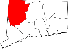 | |
| Towns | ||
| Non-consolidated city |
| |
| Boroughs | ||
| Other communities | ||
This article is issued from Wikipedia - version of the 11/29/2016. The text is available under the Creative Commons Attribution/Share Alike but additional terms may apply for the media files.