Torngat Mountains National Park
| Torngat Mountains National Park | |
|---|---|
|
IUCN category II (national park) | |
|
Nachvak Fjord | |
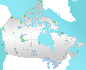 Torngat Mountains National Park Location | |
| Location | Labrador, Newfoundland and Labrador, Canada |
| Nearest city | Nain |
| Coordinates | 59°26′09″N 63°51′47″W / 59.43583°N 63.86306°WCoordinates: 59°26′09″N 63°51′47″W / 59.43583°N 63.86306°W |
| Area | 9,700 km2 (3,700 sq mi) |
| Established | July 10, 2008 |
| Governing body | Parks Canada |
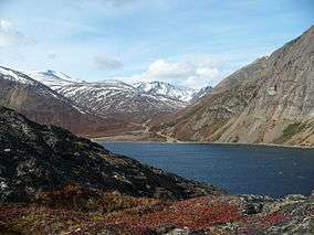
Torngat Mountains National Park is a Canadian national park, located on the Labrador Peninsula at the northern tip of Newfoundland and Labrador.
An area called Torngat Mountains National Park Reserve was set aside with enactment of the Labrador Inuit Land Claims Agreement on December 1, 2005, with the intention of creating a national park. When the Nunavik Inuit Land Claims Agreement came into effect on July 10, 2008, the park was officially established, and the National Park Reserve became Torngat Mountains National Park, the first in Labrador.[1] The park covers 9,700 square kilometres (3,700 sq mi), extending from Cape Chidley south to Saglek Fjord. It is the largest national park in Atlantic Canada and the southernmost national park in the Arctic Cordillera.
The park protects wildlife (caribou, polar bears, peregrine falcon, and golden eagle among others), while offering wilderness-oriented recreational activities (hiking, scrambling, kayaking). Set in the Torngat Mountains, the name comes from the Inuktitut word Torngait, meaning "place of spirits".
See also
References
- ↑ Torngat Mountains National Park, Park Management, The Context for Park Management, Parks Canada, 2014
External links
- Official Parks Canada website
- Parks Canada - Announcement of establishment of Torngat Mountains National Park Reserve
- Park page at Newfoundland and Labrador Government site
| National Parks |
|
|---|---|
| National Park Reserves | |
| Marine Conservation Areas | |
| National Marine Conservation Area Reserves | |
| National Landmarks | |
| National Urban Parks |
|
| |