Toranmal
| Toranmal | |
|---|---|
| town | |
|
Khadki Point, Toranmal | |
 Toranmal  Toranmal Location in Maharashtra, India | |
| Coordinates: 21°53′N 74°28′E / 21.88°N 74.46°ECoordinates: 21°53′N 74°28′E / 21.88°N 74.46°E | |
| Country |
|
| State | Maharashtra |
| District | Nandurbar |
| Area | |
| • Total | 41.43 km2 (16.00 sq mi) |
| Elevation | 1,150 m (3,770 ft) |
| Languages | |
| • Official | Marathi |
| Time zone | IST (UTC+5:30) |
| PIN | 425409 |
| Telephone code | 02565 |

Toranmal is a Hill Station in the municipal council of the Nandurbar district in the Indian state of Maharashtra.[1] One can reach through Shahada. It is a hill station located in the Satpura Range. Its Gorakhnath Temple is the site of a Yatra attended by thousands of devotees on Mahashivratri. On that occasion pilgrims walk barefoot for days from surrounding areas in the Nandurbar district but also from Maharashtra, Madhya Pradesh and Gujarat.[2]
Toranmal is located between latitude 21 degrees, 54 minutes N, and longitude 74 degrees, 27 minutes E and 74 degrees, 30 minutes E, at the height of 1,150 metres (3,770 ft) above mean sea level.[1][3]
Topography
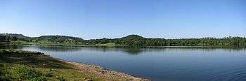
Toranmal is a small plateau with an approximate area of 41.43 sq. kilometers. The plateau has a soccer like shape from which a stream flows across the plateau from south to north. In southern part of the plateau, stream is bounded and forms the Yashavant Lake which spans about 1.59 km2 and has a maximum depth of 27 meters. Further towards the north on the same stream is the Lotus lake which derives its name from the fact that it is always covered with lotus flowers. Same stream jumps down the cliff in Sita Khai, into the gorge forming an entralling waterfall in rainy season.
Approach
Toranmal is about 55 kilometres (34 mi) from Shahada city[4] which is about 305 kilometres (190 mi) from Nashik and about 200 kilometres (120 mi) from Surat. Nearest railway station is Nandurbar which is about 76 kilometres (47 mi) and Dondaicha is about 75 kilometres (47 mi) km from Shahada Town. However, for approach from Mumbai 510 kilometres (320 mi),[5] train station to approach is Dhule (90 km) or Chalisgaon (145 km.). Nearest Airport is Surat.[4]
View Points
- Yashawant Lake[3]
- Aawashabari Point
- Sunset Point
- Coffee Garden
- Check Dam
- Gorakshanath Temple
- Nagarjun Point
- Sat Payari(Seven Steps)View Point
- Lotus Lake
- Forest Park & Medicinal Plant Garden
- Sita Khai[3]
References
- 1 2 "Toranmal - Toranmal Maharashtra, Toranmal Hill Station India". Maharashtratourism.net. Retrieved 2010-09-27.
- ↑ "Toranmal - Nandurbar, Maharashtra : Hill Stations". Whereincity.com. 2007-07-02. Retrieved 2010-09-27.
- 1 2 3 Home » Tourist Places Tourist Places. "Official Web Site Of District Nandurbar". Nandurbar.nic.in. Retrieved 2010-09-27.
- 1 2 Home » Toranmal Toranmal. "Official Web Site Of District Nandurbar". Nandurbar.nic.in. Retrieved 2010-09-27.
- ↑ "MAHARASHTRA TOURISM, The Official Website of Maharashtra Tourism Development Corporation, Govt. of India - ToranmalHillstation". Maharashtratourism.gov.in. Retrieved 2010-09-27.
- "Nandurbar District". Government of Maharashtra.