Topock, Arizona
| Topock, Arizona | |
|---|---|
| unincorporated community | |
|
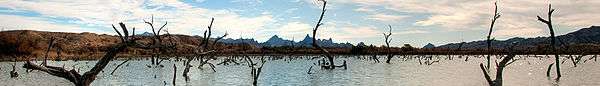
Looking down stream towards the Needles Peak Mountains in the Topock Gorge. | |
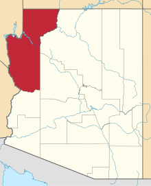
 Topock, Arizona Location in the United States | |
| Coordinates: 34°43′6″N 114°29′14″W / 34.71833°N 114.48722°WCoordinates: 34°43′6″N 114°29′14″W / 34.71833°N 114.48722°W | |
| State | Arizona |
| County | Mohave |
| Population | 1,790 |
| Time zone | MST |
| ZIP codes | 86436 |
| Area code(s) | 928 |

Topock (Mojave: Tuupak) is a small unincorporated community in Mohave County, Arizona. Topock has a ZIP Code of 86436; in 2000, the population of the 86436 ZCTA was 1,790.[1]
It lies between Bullhead City and Lake Havasu City and southeast of Needles, California, on the California–Arizona border.
Topock is known for being a boating town as well as being home to the Old Trails Arch Bridge which used to be the old Route 66 bridge featured in the film The Grapes of Wrath.[2] The crossings of the Colorado River at Topock, including the Old Trails Arch Bridge, are also featured prominently in the opening credits of the movie Easy Rider.[3]
Topock Marina located just off I-40 on Historic Route 66. Situated on the Colorado River between Needles and Lake Havasu City, the Marina is the traditional refueling point for boaters traveling between these two cities.
Topock is the site of one of Pacific Gas & Electric (PG&E)'s recompression stations on its super-rich natural gas pipeline from Texas to San Francisco completed in 1930.
History
Topock was originally called Mellen, a railroad station and steamboat landing, at the site where the Atlantic and Pacific Railroad built the Red Rock Bridge, a steel cantilever bridge across the Colorado River in May 1890 after three of its earlier less well built bridges had been washed away by the river upstream at a poorly chosen site at Eastbridge, southeast of Needles, California. The town was named for Captain "Jack" Mellon, a 40-year veteran Colorado River steamboat captain and an owner of the Colorado Steam Navigation Company, though it was misspelled as "Mellen." [4][5] From 1903 to 1909 Mellen had its own post office.[6]:113
Topock PG&E compressor station

PG&E began delivering natural gas to San Francisco and northern California in 1930 through the longest pipeline in the world, connecting the Texas gas fields to northern California with compressor stations that included compressor stations with cooling towers every 300 miles (480 km), at Topock, Arizona, on the state line, and near the town of Hinkley, California. Today there is a network of eight compressor stations linked by "40,000 miles of distribution pipelines and over 6,000 miles of transportation pipelines" serving "4.2 million customers from Bakersfield to the Oregon border."[7]
In the 1950s and 1960s, at both Topock and Hinkley compressor stations, hexavalent chromium in the form of an additive was used in rust-prevention in "the cooling towers that prepared the gas for transportation through PG&E’s pipeline to northern and central California."[7] These cooling waters were then disposed of "adjacent to the compressor stations."[7][8]
Topock Compressor Station is located in eastern San Bernardino County, approximately 12 miles southeast of Needles, California, along the Colorado River.[8] In 1996 following the Hinkley groundwater contamination lawsuits related to the dumping of hexavalent chromium, PG&E began "an investigation and cleanup process governed by the federal Resource Conservation and Recovery Act (RCRA) and the Comprehensive Environmental Response, Compensation, and Liability Act of 1980 (CERCLA). PG&E continues to provide reports on their soil investigation and remedial activities at the Topock compressor station site regarding potential future impacts to the Colorado River and to Arizona's groundwater.[8]
Topock Marsh

The Topock Marsh is one of the larger birding sites found in the Lower Colorado River Valley, between Hoover Dam and the Colorado River Delta.

On the eastern side of the site is Five Mile Landing, and at the southern end along the Colorado can be found Catfish Paradise.
See also
- Bullhead City, Arizona
- Colorado River
- Kingman, Arizona
- Lake Havasu City, Arizona
- Needles, California
- Yucca, Arizona
References
- ↑ http://factfinder.census.gov/servlet/SAFFPopulation?_event=Search&_zip=86436
- ↑ http://roadtripmemories.com/2008/12/11/the-grapes-of-wrath-filming-locations/
- ↑ Kaszynski, William (2003-05-01). Route 66: Images of America's Main Street. p. 13. ISBN 9780786415533.
- ↑ Frederic B. Wildfang, Lake Havasu City, Arcadia Publishing, 2005, pp.34-35
- ↑ US 66 Photo Gallery Needles and the Colorado River from gbcnet.com accessed 11/1/2114.
- ↑ John and Lillian Theobald, Arizona Territory Post Offices & Postmasters, The Arizona Historical Foundation, Phoenix, 1961.
- 1 2 3 "Compressor Stations Environmental Restoration Activities at Compressor Station Properties". Pacific Gas and Electricity. 2015. Retrieved 16 April 2016.
- 1 2 3 "Waste Programs Division: Cleanups: Topock Compressor Station Groundwater VRP Site". Arizona Department of Environmental Quality (AZDEQ). 2015. Retrieved 16 April 2016.
External links
- Construction of Red Rock Cantilever Bridge nearing completion in 1890. Below Needles. from hdl.huntington.org Huntington Digital Library, accessed June 30, 2015.
- Building of the Topock Bridge. The steamer is the "Gila." from hdl.huntington.org Huntington Digital Library, accessed June 30, 2015.
- Train crossing completed bridge at Red Rock Cantilever Bridge. from hdl.huntington.org Huntington Digital Library, accessed June 30, 2015.