Top of the Rockies
| Top of the Rockies | |
|---|---|
| Major junctions | |
| South end: |
|
| North end: |
|
| Highway system | |
|
Colorado State Highways
| |
Top of the Rockies is the name of a National Scenic Byway in Colorado, in the Western United States. Most of the byway is above 9,000 ft (2,700 m) and thus the name of the byway is Top of the Rockies. The byway goes over Tennessee Pass to the mining town of Leadville, Colorado.
Route description
The byway starts in Aspen, traveling on SH 82 east over Independence Pass and near the Twin Lakes to just north of the town of Granite. The route then continues north on US 24 through Leadville to Interstate 70 (I-70). A spur of the byway continues along the entire length of SH 91 from Leadville to Copper Mountain, through Fremont Pass.[1]
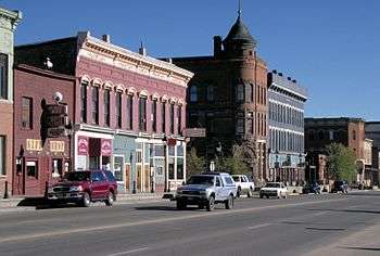
Historic downtown Leadville
Points of interest
- Tennessee Pass — A pass in the Rockies
- Leadville, Colorado — highest incorporated city in the United States
- Valley of the Ghosts — A grouping of three ghost towns
- Mount Elbert — Highest peak in Colorado
Major intersections
Main route
| County | Location | mi | km | Destinations | Notes |
|---|---|---|---|---|---|
| Pitkin | Aspen | 0.0 | 0.0 | ||
| Lake | | Byway continues on US 24 north | |||
| Leadville | |||||
| Eagle | Minturn | Western terminus of US 24 | |||
| 1.000 mi = 1.609 km; 1.000 km = 0.621 mi | |||||
Fremont Pass route
| County | Location | mi | km | Destinations | Notes |
|---|---|---|---|---|---|
| Lake | | 0.000 | 0.000 | ||
| Summit | | 22.605 | 36.379 | Interchange | |
| 1.000 mi = 1.609 km; 1.000 km = 0.621 mi | |||||
See also
-
 Colorado portal
 -
 U.S. Roads portal
 - List of national scenic byways in Colorado
References
- ↑ Staff. "Top of the Rockies – CDOT". Colorado Department of Transportation. Retrieved December 30, 2013.
External links
- Road Trip on the Top of the Rockies Scenic Byway
- Top of the Rockies on Official Colorado Byways site
- Top of the Rockies
This article is issued from Wikipedia - version of the 12/30/2013. The text is available under the Creative Commons Attribution/Share Alike but additional terms may apply for the media files.