Tonkin Street

.JPG)
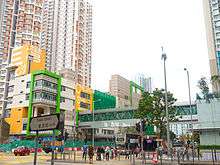


Tonkin Street (Chinese: 東京街) is a street between Sham Shui Po and Cheung Sha Wan of New Kowloon in Hong Kong. It runs northeast to southwest and crosses many major roads in the Cheung Sha Wan area. After extensive reclamation in West Kowloon during the 1990s, an extension Tonkin Street West (東京街西) was built.
Name
Its Chinese name Tung King (東京) means eastern capital, which is a very common name in historical China and neighbour countries. Although the name in Chinese character is currently only used by Tokyo, eastern capital of Japan, a hint from its English name suggests that the name is associated with the eastern capital of Vietnam, Tonkin, namely modern-day Hanoi. British named roads and streets in the area by the trading cities in the surrounding of Hong Kong.
Tonkin Street
Tonkin Street starts north from the junction with Kwong Lee Road near Lei Cheng Uk Estate and runs south across Po On Road, Shun Ning Road, Castle Peak Road, Un Chau Street, Fuk Wa Street, Cheung Sha Wan Road, Lai Chi Kok Road and ends at Tung Chau Street.
Part of the street maintains a nullah in the middle. Some notable landmarks can be found along the street. Lei Cheng Uk Estate is one of the early public housing estates in Hong Kong. Lei Cheng Uk Han Tomb Museum embedded a tomb dating back to Eastern Han Dynasty (AD 25 - 220). The former Cheung Sha Wan Factory Estate marked the prosperity of Hong Kong industry from 1950s to the early 1980s. The estate was suggested to be workshops for fashionists. Other abandoned buildings like Cheung Sha Wan Police Quarters and Cheung Sha Wan Abattoir are the colonial marks in Hong Kong. Amidst the city, an enclosed golf court can be found at the junction with Lai Chi Kok Road.
Unearth of World War II explosive
On 8 April 2006, the workers unearthed 588 pieces of explosive articles including cannon shells, bullets and grenades, in a drainage project in the street near Fuk Wing Street. The explosive was buried 1 to 3 metres beneath the surface. It belonged to former British Army around the period of World War II. Streets and MTR exits of surrounding area were closed to let the ammunition experts from Hong Kong Police Force to detonated these explosive. More pieces were unearthed at the same site on 27 April 2006.
Tonkin Street West
Tonkin Street West (東京街西) continues Tonkin Street from Tung Chau Street to Lin Cheung Road near the interchange station of West Rail Line Nam Cheong Station and MTR Nam Cheong Station, via Ying Wa Street and Sham Mong Road.
See also
| Wikimedia Commons has media related to Tonkin Street. |
Coordinates: 22°20′15″N 114°09′36″E / 22.33743°N 114.15987°E