Tongzhou District, Beijing
| Tongzhou 通州区 | |
|---|---|
| District | |
|
| |
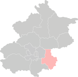 Location of Tongzhou District in Beijing | |
| Coordinates: 39°54′36″N 116°39′23″E / 39.91000°N 116.65639°ECoordinates: 39°54′36″N 116°39′23″E / 39.91000°N 116.65639°E | |
| Country | People's Republic of China |
| Municipality | Beijing |
| Township-level divisions |
4 subdistricts 10 towns 1 ethnic township |
| District seat | Zhongcang Subdistrict |
| Area | |
| • Total | 906 km2 (350 sq mi) |
| Elevation | 32 m (106 ft) |
| Population (2010) | |
| • Total | 1,184,000 |
| • Density | 1,300/km2 (3,400/sq mi) |
| Time zone | China Standard (UTC+8) |
| Postal code | 101149 |
| Area code(s) | 0010 |
| Website | http://www.bjtzh.gov.cn/ |

| Tongzhou | |||||||||
|
"Tongzhou", as written in Chinese | |||||||||
| Chinese | 通州 | ||||||||
|---|---|---|---|---|---|---|---|---|---|
| Postal | Tungchow | ||||||||
| |||||||||
| Tongxian (Tong County) | |||||||||
| Simplified Chinese | 通县 | ||||||||
| Traditional Chinese | 通縣 | ||||||||
| Postal | Tungchow | ||||||||
| |||||||||

Tongzhou District (simplified Chinese: 通州区; traditional Chinese: 通州區; pinyin: Tōngzhōu Qū; Wade–Giles: T'ung1chou1 Ch'ü1, alternate spellings Tungchow Tungchou (T'ung-chou), or Tong County during 1914-1997) is a district of Beijing. It is located in southeast Beijing and considered the eastern gateway to the nation's capital. Downtown Tongzhou itself lies around 20 km east of central Beijing, at the northern end of the Grand Canal (on the junction between the Tonghui Canal and the Northern Canal) and at the easternmost end of Chang'an Avenue. The entire district covers an area of 906 square kilometres (350 sq mi), or 6% of Beijing's total area. It had a population of 673,952 at the 2000 Census, and has seen significant growth and development since then, growing to a population of 1,184,000 at the 2010 Census. The district is subdivided into 4 subdistricts, 10 towns, and 1 ethnic township.
History
Tongzhou was founded in 195 BC during the Western Han Dynasty under the name of Lu (路) County, although there is evidence for human settlement in the Neolithic. At the start of the Eastern Han Dynasty the character Lu by which it was known was altered by the addition of a water radical to become Lu (潞). In 1151 under the Jin dynasty Lu County was renamed Tongzhou, roughly meaning 'the place for passing through', in recognition of its importance as the land and water approach to Beijing.
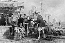
Qing & Republican era
In July 1937, subsequent to the galvanising Marco Polo Bridge Incident, Tongzhou became another site of determined Chinese resistance. In the Tongzhou Mutiny troops of the nominally Japanese-puppet East Hopei Army rebelled and came to the aid of hard-pressed Guomindang troops, and attacked the Japanese garrison. In the fall of Tongzhou to the Nationalists, many civilians were murdered and abused as well as captured Japanese military personnel.
People's Republic
The place name changed to Tong County (simplified Chinese: 通县; traditional Chinese: 通縣; pinyin: Tōng Xiàn) when the area was placed under the new municipal region of Beijing in 1914. It reverted again to Tongzhou when the area was upgraded in 1997 to a district.
On 11 July 2015, Tongzhou became the second administrative seat of Beijing as a "sub-administrative center" for the municipality.[1] This was done to reduce crowding within the city center of Beijing.[2]
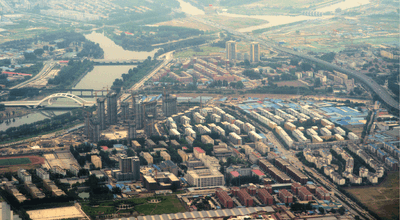
Geography and environment
.jpg)
Tongzhou District borders the Beijing districts of Shunyi, Chaoyang and Daxing, Wuqing District of Tianjin Municipality, and Langfang City (both the Sanhe City−Dachang County−Xianghe County exclave and Guangyang District) of Hebei province, and is 12 miles from Tiananmen Square and 10 miles from Beijing Capital International Airport.
Tongzhou is situated on the North China Plain with an average elevation of 20 metres (66 ft). Its climate belongs to the mild temperate zone, with distinct seasons including hot summers and freezing winters. Dust storms are common. It has an annual mean temperature of 11.3 °C (52.3 °F). and 620 mm (24 in) of rainfall. Several large rivers, amongst them the Wenyu, the Liangshui and Chaobai flow through the district.
Administrative divisions
Tongzhou District is divided into 4 subdistricts, 10 towns, and 1 ethnic township. Two of the towns of which carry the "area" (地区) label.[3][4]
| Name | Chinese (S) | Hanyu Pinyin | Population (2010)[5] | Area (km2) |
|---|---|---|---|---|
| Zhongcang Subdistrict | 中仓街道 | Zhōngcāng Jiēdào | 57,550 | 6.50 |
| Xinhua Subdistrict | 新华街道 | Xīnhuá Jiēdào | 8,891 | 3.25 |
| Beiyuan Subdistrict | 北苑街道 | Běiyuàn Jiēdào | 73,423 | 36.60 |
| Yuqiao Subdistrict | 玉桥街道 | Yùqiáo Jiēdào | 64,482 | 11.20 |
| Yongshun Area | 永顺地区 | Yǒngshùn dìqū | 195,194 | 39.46 |
| Liyuan Area | 梨园地区 | Líyuán dìqū | 140,520 | 24.87 |
| Songzhuang Town | 宋庄镇 | Sòngzhuāng Zhèn | 104,143 | 116.00 |
| Zhangjiawan Town | 张家湾镇 | Zhāngjiāwān Zhèn | 89,273 | 105.80 |
| Kuoxian Town | 漷县镇 | Kuòxiàn Zhèn | 61,413 | 113.68 |
| Majuqiao Town | 马驹桥镇 | Mǎjūqiáo Zhèn | 107,048 | 82.00 |
| Xiji Town | 西集镇 | Xījí Zhèn | 43,244 | 95.29 |
| Taihu Town | 台湖镇 | Táihú Zhèn | 99,039 | 82.50 |
| Yongledian Town | 永乐店镇 | Yǒnglèdiàn Zhèn | 40,241 | 105.00 |
| Lucheng Town | 潞城镇 | Lùchéng Zhèn | 72,611 | 144.00 |
| Yujiawu Hui Ethnic Township | 于家务回族乡 | Yújiāwù Huízú Xiāng | 27,184 | 65.70 |
Transportation
Downtown Tongzhou is connected to downtown Beijing by Jingtong Expressway and Batong Line, Beijing Subway. Beijing's Fifth and Sixth Ring Road are roughly equidistant from Tongzhou's CBD. Highways lead to Shenyang, Harbin and Tianjin/Tanggu. A seventh ring road, a sixth subway line, a Beijing-Shanghai high-speed railway and a Beijing-Tianjin shuttle are under construction.
Metro
Tongzhou is currently served by two metro lines operated by Beijing Subway:
Beijing Subway Line 6
 Batong Line - Tongzhou Beiyuan, Guoyuan, Jiukeshu, Liyuan, Linheli, Tuqiao
- Yizhuang Line - Tongjinanlu, Jinghailu, Ciqu South, Ciqu
Industry and tourism
There are seven industrial zones with a total area of 64 square kilometres (25 sq mi) in Tongzhou, focusing on modern manufacturing and high-tech industries. Downtown Tongzhou is earmarked for redevelopment into a comprehensive central business district with an emphasis on consumer retail. In agriculture, the district places emphasis on horticulture, fruit-farming, seed-growing and aquatics. The district government is currently promoting Tongzhou's position at the head of the Grand Canal to attract tourists to its Grand Canal Cultural Park.
The Songzhuang artists' village, where many Chinese contemporary artists live and work, is located in the Tongzhou District.[6] [7]
Education and health
Tongzhou has good education facilities including 113 kindergartens, 141 primary schools, 51 high schools and many adult education colleges. It also boasts the Beijing Materials Institute, Beijing University of Technology and the Beijing Institute of Music. Its hospitals include a specialist tuberculosis treatment centre and a hospital specializing in traditional Chinese medicine.
Private schools include:
References
- ↑ "北京加快"行政副中心"建设 将聚焦通州". ifeng.com. iFeng (Phoenix Television). Retrieved 15 July 2015.
- ↑ Johnson, Ian (2015-06-25). "China Aims to Move Beijing Government Out of City's Crowded Core". The New York Times. Retrieved 2016-11-03.
- ↑ These towns are officially classified as subdistricts, but as they coincide with the area of the same name, they are commonly named "areas" (地区)
- ↑ 2011年统计用区划代码和城乡划分代码:通州区 (in Chinese). National Bureau of Statistics of the People's Republic of China. Retrieved 2013-01-07.
- ↑ shi, Guo wu yuan ren kou pu cha ban gong; council, Guo jia tong ji ju ren kou he jiu ye tong ji si bian = Tabulation on the 2010 population census of the people's republic of China by township / compiled by Population census office under the state; population, Department of; statistics, employment statistics national bureau of (2012). Zhongguo 2010 nian ren kou pu cha fen xiang, zhen, jie dao zi liao (Di 1 ban. ed.). Beijing Shi: Zhongguo tong ji chu ban she. ISBN 978-7-5037-6660-2.
- ↑ "Branding Songzhuang". Studio 360:Made in China. 2007-11-16. External link in
|title=(help) - ↑ "SongZhuang Artists Community". Retrieved November 28, 2008.
External links
| Wikivoyage has a travel guide for Tongzhou. |
| Wikimedia Commons has media related to Tongzhou District. |
- Official website of Tongzhou District
- Official website of Tongzhou District (simplified Chinese)
| Administration |
| ||||||||||
|---|---|---|---|---|---|---|---|---|---|---|---|
| Education | |||||||||||
| Transportation |
| ||||||||||
| Visitor attractions |
| ||||||||||
| Municipal agencies |
| ||||||||||
| |||||||||||