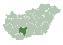
Tolna County
| Tolna County | |||
|---|---|---|---|
 | |||
| |||
 | |||
| Country | Hungary | ||
| Region | Southern Transdanubia | ||
| County seat | Szekszárd | ||
| Government | |||
| • President of the General Assembly | Tamás Fehérvári (Fidesz-KDNP) | ||
| Area | |||
| • Total | 3,703.16 km2 (1,429.80 sq mi) | ||
| Area rank | 15th in Hungary | ||
| Population (2011 census) | |||
| • Total | 230,361 | ||
| • Rank | 18th in Hungary | ||
| • Density | 62/km2 (160/sq mi) | ||
| Postal code |
702x – 7252, 7352 – 7361 | ||
| Area code(s) | (+36) 74, 75 | ||
| ISO 3166 code | HU-TO | ||
| Website |
www | ||


Tolna is an administrative county (comitatus or megye) in present Hungary and in the former Kingdom of Hungary. It lies in central Hungary, on the west bank of the river Danube. It shares borders with the Hungarian counties Somogy, Fejér, Bács-Kiskun, and Baranya. The capital of Tolna county is Szekszárd. Its area is 3703 km².
History
Tolna (in Latin: comitatus Tolnensis) was also the name of a historic administrative county (comitatus) of the Kingdom of Hungary. Its territory, which was about the same as that of present Tolna county, is now in central Hungary. The capital of the county was Szekszárd.
Demographics
In 2015, it had a population of 225,936 and the population density was 61/km².
| Year | County population[1] | Change |
|---|---|---|
| 1949 | 275,644 | n/a |
| 1960 | -1.29% | |
| 1970 | -4.90% | |
| 1980 | 2.90% | |
| 1990 | -4.73% | |
| 2001 | -1.57% | |
| 2011 | -7.74% |
Ethnicity
Besides the Hungarian majority, the main minorities are the Germans (approx. 10,000) and Roma (8,500).
Total population (2011 census): 230,361
Ethnic groups (2011 census):[2]
Identified themselves: 214 953 persons:
- Hungarians: 194 685 (90,57%)
- Germans: 10 195 (4,74%)
- Gypsies: 8 768 (4,08%)
- Others and indefinable: 1 305 (0,61%)
Approx. 32,000 persons in Tolna County did not declare their ethnic group at the 2011 census.
Religion
Religious adherence in the county according to 2011 census:[3]
- Catholic – 47.2% (Roman Catholic – 47.1%; Greek Catholic – 0.1%)
- Reformed – 8.0%;
- Evangelical – 3.0%;
- Other religions – 1.1%;
- Non-religious – 15.5%;
- Atheism – 1.0%;
- Undeclared – 24.1%.
Politics
The Tolna County Council, elected at the 2014 local government elections, is made up of 15 counselors, with the following party composition:[4]
| Party | Seats | Current County Assembly | ||||||||
|---|---|---|---|---|---|---|---|---|---|---|
| Fidesz-KDNP | 8 | |||||||||
| Movement for a Better Hungary (Jobbik) | 3 | |||||||||
| Hungarian Socialist Party (MSZP) | 2 | |||||||||
| Democratic Coalition (DK) | 1 | |||||||||
| People's Party (Néppárt) | 1 | |||||||||
Municipalities
City with county rights
- Szekszárd (county seat)
Towns
(ordered by population, according to the 2001 census)
- Dombóvár (21,066)
- Paks (20,954)
- Bonyhád (14,401)
- Tolna (12,195)
- Tamási (9,830)
- Dunaföldvár (9,212)
- Bátaszék (6,925)
- Simontornya (4,606)
- Nagymányok (2,468)
- Gyönk (2,051)
Villages
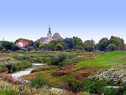
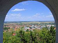
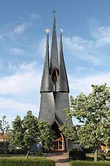
Gallery
_2.jpg)

References
- ↑ népesség.com, "Tolna megye népessége 1870-2015"
- ↑ 1.1.6. A népesség anyanyelv, nemzetiség és nemek szerint – Frissítve: 2013.04.17.; Hungarian Central Statistical Office (Hungarian)
- ↑ 2011. ÉVI NÉPSZÁMLÁLÁS, 3. Területi adatok, 3.17 Tolna megye, (Hungarian)
- ↑ A Tolna Megyei Önkormányzat Közgyűlésnek tagjai, (Hungarian)
External links
| Wikimedia Commons has media related to Tolna County. |
- Official site in Hungarian and German
- Tolnai Népújság (teol.hu) - The county portal
County seat: Szekszárd | ||
| Cities and towns | | |
| Villages |
| |
| Other topics |
| |
Coordinates: 46°30′N 18°35′E / 46.500°N 18.583°E