Tokyo Bay Aqua-Line
| Tokyo Bay Aqua-Line 東京湾アクアライン | |
|---|---|
|
Tokyo Bay Aqua-Line (bridge section) | |
| Coordinates | 35°27′47″N 139°52′31″E / 35.46306°N 139.87528°ECoordinates: 35°27′47″N 139°52′31″E / 35.46306°N 139.87528°E |
| Carries |
4 lanes of |
| Crosses | Tokyo Bay |
| Locale | |
| Other name(s) | Trans-Tokyo Bay Highway |
| Characteristics | |
| Design |
|
| Total length |
|
| Width | 22.9 metres (75 ft)[2] |
| Longest span | 240 metres (787 ft)[3] |
| Piers in water | 42[2] |
| Clearance below | 29 metres (95 ft)[2] |
| History | |
| Fabrication by | |
| Construction begin | 1989 |
| Construction cost | ¥1.4 trillion |
| Opened | 18 December 1997 |
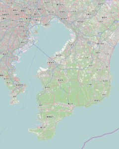 Tokyo Bay Aqua-Line Location in Tokyo Bay and Bōsō Peninsula | |
|
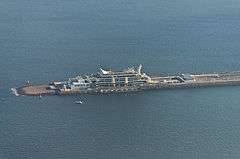
Umihotaru, where bridge transitions to tunnel | |
| Overview | |
|---|---|
| Status |
|
| Start | Umihotaru Island |
| End | Ukishima, Kawasaki, Kanagawa |
| Operation | |
| Constructed | Taisei[6] |
| Technical | |
| Number of lanes | 2 (unidirectional) in each of 2 tunnels |
| Highest elevation | sea level |
| Lowest elevation | −45 metres (−148 ft) |
| Width |
|
| Grade | 4%[7] |
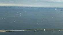
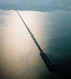
The Tokyo Bay Aqua-Line (東京湾アクアライン Tōkyō-wan Akua-rain[8]), also known as the Trans-Tokyo Bay Highway, is a bridge–tunnel combination across Tokyo Bay in Japan. It connects the city of Kawasaki in Kanagawa Prefecture with the city of Kisarazu in Chiba Prefecture, and forms part of National Route 409. With an overall length of 14 km, it includes a 4.4 km bridge and 9.6 km tunnel underneath the bay—the fourth-longest underwater tunnel in the world.[9]
Overview
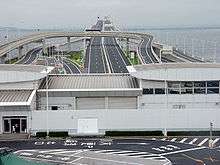
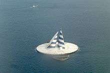
At the bridge–tunnel crossover point, there is an artificial island called Umihotaru (海ほたる Umi-hotaru, literally meaning "sea firefly") with a rest area consisting of restaurants, shops and amusement facilities. Air is supplied to the tunnel by a distinctive tower in the middle of the tunnel, called the Kaze no Tō (風の塔, "the tower of wind"), which uses the bay's almost-constant winds as a power source.
The road opened on December 18, 1997 after 23 years of planning and 9 years of construction at a cost of 1.44 trillion yen (11.2 billion USD at the time of opening).
The Tokyo Bay Aqua-Line reduced the drive between Chiba and Kanagawa, two important industrial regions, from 90 to 15 minutes,[10] and also contributed to cutting the travel time to the sea leisure area in the southern part of the Bōsō Peninsula from Tokyo and Kanagawa. Before the tunnel opened, one had to drive around about 100 km along the shores of Tokyo Bay and pass through downtown Tokyo.
One goal expressed during the planning of the Aqua-Line was to reduce the traffic through downtown Tokyo, but as the highway toll is quite high, the reduction in Tokyo traffic has not been as great as expected.
Many highway bus services now use the Tokyo Bay Aqua-Line, including lines from Tokyo Station, Yokohama Station and Haneda Airport to Kisarazu, Kimitsu, Kamogawa, Katsuura and Tateyama.
Tolls
The cash toll for a single trip on the Aqua-Line is ¥3000 for ordinary-size cars (¥2400 for kei cars); however, using the ETC (electronic toll collection) system, the fare is ¥2320 (¥1860 for kei cars). The ETC toll is reduced to ¥1000 on Saturdays, Sundays and Holidays. In general, tolls for usage of the Aqua-Line in either direction are collected at the mainline toll plaza on the Kisarazu end.
| Type of car | Toll | ETC Aqua-Line Special discount | ETC Pilot Test discount (from July2009) |
|---|---|---|---|
| Normal cars | 3,000JPY | 2,320JPY | 800JPY |
| Midsize cars | 3,600JPY | 2,780JPY | 960JPY |
| Large cars | 4,950JPY | 3,830JPY | 1,320JPY |
| Specific large cars | 8,250JPY | 6,380JPY | 2,200JPY |
| Kei-cars and motorcycles | 2,400JPY | 1,860JPY | 640JPY |
See also
References
- ↑ "Developments of transportation and industries, do bring a more comfortable life to every body.". Tokyo wan Aqua-line. 1998. Archived from the original on 3 December 1998. Retrieved 6 March 2015.
- 1 2 3 4 Shioi, Y.; Nakamura, S. (1994). "8: Design Concept of the Trans-Tokyo Bay Bridge". In Pritchard, B.P. Continuous and Integral Bridges. London: E & FN Spon. pp. 75–84. ISBN 0-419-19030-9. Retrieved 8 March 2015.
- ↑ Nagai, Masatsugu; Okui, Yoshiaki; Kawai, Yutaka; Yamamoto, Masaaki; Saito, Kimio (2014). "23: Bridge Engineering in Japan". In Chen, Wai-Fah; Duan, Lian. Handbook of International Bridge Engineering. Boca Raton: CRC Press. p. 1048. ISBN 978-1-4398-1030-9. Retrieved 6 March 2015.
- ↑ "Steel Bridges: Structures in Japan". Yokogawa Bridge Corporation. Retrieved 6 March 2015.
- ↑ "Girder bridges". JFE Engineering Corporation. Retrieved 6 March 2015.
- ↑ "Taisei Corporation's Journey over 140 Years" (PDF). Taisei Corporation. 2014. Retrieved 8 March 2015.
- ↑ Funasaki, Tsuneyoshi; Yamada, Norio; Izumi, Yasutaka; Miki, Keizou (1998). "Construction of Trans-Tokyo Bay Highway". IABSE Reports. 78: 43–48. doi:10.5169/seals-59019.
- ↑ Katakana-shingo-jiten, Gakken 2003, ISBN 4-05-301351-8
- ↑ Hotta, Kenji (2002). "4: Tokyo Bay Reformation". In Chen, Jiyu; Eisma, Doeke; Hotta, Kenji; Walker, H. Jesse. Engineered Coasts. Dordrecht: Kluwer Academic. pp. 94–95. ISBN 1-4020-0521-0. Retrieved 6 March 2015.
- ↑ http://www.tollroadsnews.com/node/2126
External links
| Wikimedia Commons has media related to Tokyo Wan Aqua-Line. |
- Japan Highways site (in Japanese)
- NEXCO East's info regarding U-turns at Umi-hotaru (in Japanese)
- Trans-Tokyo Bay Highway at Structurae. Retrieved on 6 March 2015.
- Tokyo Bay Aqualine at Structurae. Retrieved on 6 March 2015.
- Tokyo Bay Aqualine Bridge at Structurae. Retrieved on 6 March 2015.
- Tokyo Bay Aqualine Tunnel at Structurae. Retrieved on 6 March 2015.
- Alfred, Randy (18 December 2008). "Dec. 18, 1997: 360 Seconds Under Tokyo". WIRED. Retrieved 6 March 2015.
- "The World's Largest-Scale Marine Civil Engineering Project: The Trans-Tokyo Bay Highway" (PDF). KAJIMA News & Notes. Autumn 1997. pp. 2–5. Retrieved 6 March 2015.
- Uchida, K; Shioi, Y; Hirukawa, T; Tatsuoka, F (8–12 August 1993). Wu, JTH; Barrett, R.K., eds. The Trans-Tokyo Bay Highway project - a huge project currently under construction. Transportation Facilities Through Difficult Terrain. Aspen-Snowmass, Colorado. pp. 57–87. ISBN 90-5410-343-4.
- Tatsuoka, F. (1998). "Geotechnical Engineering Aspects of Trans-Tokyo Bay Highway Project" (PDF). Saitama University. Retrieved 8 March 2015.
- "Trans-Tokyo Bay Highway" (PDF). Trans-Tokyo Bay Highway Corporation. c. 1990. Retrieved 8 March 2015.