Tlapanaloya
| Tlapanaloya | ||
|---|---|---|
| Town | ||
|
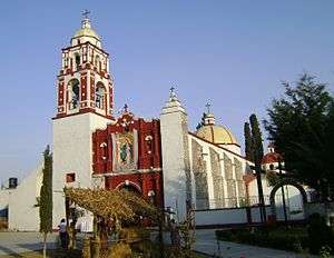
La Asunción Parish in Tlapanaloya | ||
| ||
| Nickname(s): Tlapa | ||
 Tlapanaloya | ||
| Coordinates: 19°56′9″N 99°6′7″W / 19.93583°N 99.10194°WCoordinates: 19°56′9″N 99°6′7″W / 19.93583°N 99.10194°W | ||
| Country |
| |
| State | State of Mexico | |
| Municipality | Tequixquiac | |
| Founded | 1168 | |
| Municipal Status | 1820 | |
| Area | ||
| • Total | 10.83 km2 (4.18 sq mi) | |
| Elevation (of seat) | 2,100 m (6,900 ft) | |
| Population (2010) | ||
| • Town | 6,466 | |
| Time zone | CST (UTC-6) | |
| Postal code (of seat) | 55653 | |
| Website | http://www.tequixquiac.gob.mx/ | |

Tlapanaloya is a town inside municipality of Tequixquiac in Mexico State in Mexico. The town is bordered on the north La Heredad Ranch ranching The Homestead, south to the Tajo de Tequixquiac, east village Hueypoxtla and west by the town of Santiago Tequixquiac. The name Tlapanaloya is a nahuatl toponymy, means Place where is broken stones, te- is stone, tlapana is to brake, loyan is place.[1] [2]
Geography

The town of Tlapanaloya, is a urban place populated in the municipality of Tequixquiac. The town is divided in four barrios (neighborhood.) and two colonias ejidales (Agricultural colony).[3]
In Tlapanaloya cross a river Salado de Hueypoxtla, the water most important by irrigation; over hills there are many arroyos and jagueyes.
The orography is formed by hills and planes; the biggest hill is Monte Alto, the Tlapanaloya territory is a dry planes with lime stones.
History
.jpg)
Tetlapanaloyan was an eleven places of Hueypoxtla province that made a tax payment for the Aztec empire.[4] This site was an Aztec altepetl (village) inhabited by otomi and nahua people.
Spanish period
In 1542, Tlapanaloya was given in encomienda to Spanish Juan Díaz de Lo Real, he built haciendas over Indian's agricultural lands and pay taxes to Hueypoxtla for Mexico City bishop.[5]
Century XXI
On March 20, 2011, crop circles appear in crops of oats in the village of Tlapanaloya in the La Vega escada denominda 200 meters from the road connecting the towns of Santiago Tequixquiac and Apaxco, the artistic circles, or extra-stellar messages for some people in Mexico first evidence that transcended international in composition and distribution as alleged alien messages.[6][7]
Government and administrative divisions
Tlapanaloya is a town inside Tequixquiac municipality, the government known as Delegación, this town has got regidores (councils) governing with municipal president.
Neighborhoods
| Neighborhood |
|---|
| Tlapanaloya Downtown |
| La Plazuela |
| La Rinconada |
| Monte Alto |
| La Arenilla |
Agricultural colonies
| Agricultural colony |
|---|
| Colonia Francisco I. Madero |
| Colonia Pajaritos |
Culture
Historical monuments
.jpg)
- La Asunción parish is a most important monument in Tlapanaloya town, is located at main square. It's a baroque church subject to Cuautitlan Diosese.
- Salado River bridge is a colonial construction by camino real way to Santiago Tequixquiac.
- La Esperanza hacienda is a Spanish building connecting with other haciendas and old towns.
References
- ↑ "Handbook of Middle American Indians, Volume 12: Guide to Ethnohistorical Sources" (in Spanish). Archived from the original on 2014. Retrieved 2008-11-27.
- ↑ Rodríguez Peláez, María Elena, Monografía Municipal de Tequixquiac, Instituto Mexiquense de Cultura, Toluca de Lerdo, 1999, p.p. 14.
- ↑ Bando municipal de Tequixquiac
- ↑ "Monografía municipal de Tequixquiac". Retrieved 1999. Check date values in:
|access-date=(help) - ↑ "Monografía municipal de Hueypoxtla". Retrieved 1999. Check date values in:
|access-date=(help) - ↑ Crop cicles in Tequixquiac, Estado de México, El Universal
- ↑ Tlapanaloya, Crop cicles.