Tlalnepantla de Baz
| Tlalnepantla de Baz | |
|---|---|
| City & Municipality | |
 | |
| Nickname(s): Tlalne or Tlane | |
| Motto: Culture, Work and Progress | |
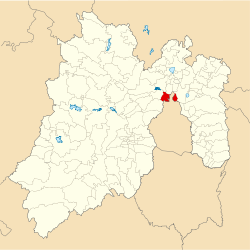 Location of Tlalnepantla in the State of Mexico | |
| Coordinates: 19°32′12″N 99°11′41″W / 19.53667°N 99.19472°WCoordinates: 19°32′12″N 99°11′41″W / 19.53667°N 99.19472°W | |
| Country |
|
| State |
|
| Region | Tlalnepantla |
| Metro area | Greater Mexico City |
| Municipal Status | September 13, 1948 |
| Municipal Seat | Tlalnepantla |
| Government | |
| • Type | Ayuntamiento |
| • Municipal President | Guillermo Alfredo Martínez González |
| Area | |
| • Total | 83.48 km2 (32.23 sq mi) |
| • Land | 77.17 km2 (29 sq mi) |
| • Water | 1.10 km2 (3.28 sq mi) |
| Elevation | 2,250 m (7,380 ft) |
| Population (2010 Census) | |
| • Total | 664,225 |
| Time zone | CST (UTC-6) |
| • Summer (DST) | CDT (UTC-5) |
| Postal code (of seat) | 54000 |
| Area code(s) | 55 |
| Demonym | Tlalnepantlense |
| Website | Official website (Spanish) |
Tlalnepantla de Baz (better known as Tlalnepantla, and incorrectly called "Tlanepantla") is a city and a municipality of the state of Mexico, north of Mexico City (Ciudad de Mexico). Tlalnepantla comes from the Náhuatl words tlalli (land) and nepantla (middle) to mean the middle land. The city was known in prior times as Tlalnepantla de Galeana and Tlalnepantla de Comonfort, to honor Hermenegildo Galeana and Ignacio Comonfort, respectively. The current addition of Baz comes from the last name of Gustavo Baz Prada, an important politician and soldier of Emiliano Zapata's army during the Mexican Revolution. After the Revolution, Baz Prada became Governor of the State of Mexico and President of the National Autonomous University of Mexico (UNAM). It is located in the northeastern part of the state of Mexico, in the Valley of Mexico north of Mexico City proper.[1] Together with Atizapan, it comprises the dense Region XII (Mexico State) of Mexico State.
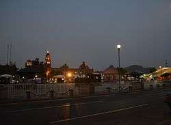
The city
History
Around the 11th century, a people called the Amaquemecan (after whom the municipality of Amecameca is named), migrated to this area following their leader Xolotl to look for a better climate and more food to sustain themselves. This same Xolotl founded the Tenayuca Oztopolco chiefdom and made the first census ever in the Americas. The Acolhuas, Tepanecas and Otomis were already established in this land so alliances were made. Despite this, the region eventually was conquered and made a tributary of the Aztec empire. After the Spanish Conquest, the area was evangelized by the Franciscans. The founding of modern Tlalnepantla was the result of a dispute between the towns of Tenayuca and Teocalhueyacan as to which should be the site of Franciscan monastery and religious center for the area. The result was to place the monastery at the midpoint between these two towns, and hence the name (middle land). This monastery, named Corpus Christi was built in 1550. After independence, Tlalnepantla was originally part of Mexico City, but in 1825, it was recognized as a district of the State of Mexico. During the Presidency of Porfirio Díaz Mori, Tlalnepantla began industrial development, and in the 1950s underwent a demographic explosion after being declared a city in 1948.[1] The population as of the 2010 INEGI census was 653,410 people, representing 98.37% of municipal population.[2]
Infrastructure

Tlalnepantla is a big modern city with an important mall (Mundo E) and hotels: Crowne Plaza Lancaster, Camino Real, Fiesta Inn, NH hotel, Holiday Inn, and Four Points by Sheraton. Tlalnepantla offers different options for entertainment and food: Punta Recoleta Restaurante (Argentine food), Boca del Rio (Mexican food restaurant), Real de Catorce (Show and Mexican food restaurant), La Antigua (Mexican food restaurant).
The most important avenues and boulevards in Tlalnepantla City are:
- Gustavo Baz Ave.
- Mario Colin Ave.
- Adolfo Lopez Mateos Blvd.
- Presidente Juárez Ave.
As well as the Periférico and the Mexico-Querétaro Freeway with 15 lanes in Tlalnepantla. (This is a section of Mexican Federal Highway 57, the Pan-American Highway.)
Tlanepantla is well served by the local pesero, intercity bus network and the suburban train.
Education
Schools located in the city include:
- UNAM, Facultad de Estudios Superiores Iztacala (FES Iztacala)
- National Autonomous University of Mexico
- Instituto Tecnológico de Tlalnepantla (ITTLA)
- Tlalnepantlas Institute of Technology
- Centro Universitario Emilio Cardenas (CUDEC)
- Escuela Bancaria y Comercial (EBC Tlalnepantla)
- Universidad Latinoamericana (ULA)
- Sistema Educativo Indoamericano (INDO)
- Centro Eleia
- Universidad Interamericana para el Desarrollo (UNID)
- Universidad de Cuautitlan Izcalli (UCI)
- Ateneo de Tlalnepantla
- Universidad ETAC (Escuela Técnica en Administración y Comercio)
Private schools:
Economy
There are more than 2,700 industries located here, making Tlalnepantla one of the most industrialized areas in the country, along with Naucalpan and Monterrey, ranking first in the state of Mexico. The most common industries include: food processing, bottling, tobacco products, textiles, paper products, non-metallic mineral products and metals, chemicals and petroleum products, machinery and wood products. Its industrial zone is one of the largest in the country. The area also includes more than 15,000 retail businesses, including the Mundo E Mall and several large tianguis.
Notable sites

The church and monastery of Corpus Christi was built by both Mexicas and Otomis of pink and gray stone. The side gate, called the Porciúncula, shows clearly the influence of both these peoples. In 1963, the church gain cathedral status. The aqueduct that extends from Tlalnepantla to Villa de Guadalupe as well as the Caja del Agua are works that date from the colonial period. The Hacienda of Santa Mónica and the Hacienda de Emmedio are well-preserved. The Centro Cultural Sor Juana Inés de la Cruz has a collection of 130 fotografías del Tlalnepantla from the end of the 19th century to 1960 as well as other historical objects.[1]
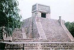
Two notable pyramids lie in the municipality's limits: Tenayuca and Santa Cecilia Acatitlan. The pyramid at Tenayuca is a smaller version of the Templo Mayor the Aztecs built in Tenochtitlan. It has dual staircases on the west side, each leading to two temples, at the top of the pyramid. One was dedicated to Tlaloc and the other to Huizilopochtli. Serpent sculptures surround the pyramid on three sides and are possibly of pre Aztec origin.[3] A small museum on the grounds holds artifacts diagrams and models of the site and the history that surrounds it. Another, smaller pyramid is at Santa Cecilia Acatitlan, just north of Tenayuca. This one was rebuilt as the original was destroyed and some of it blocks were used to build the Santa Cecelia Parish church that is next to it. This pyramid has one staircase one temple atop. On the plaza is the Herpes Museum, which houses a small collection of pre Hispanic sculpture.[3]
Brother Cities
Notable people
- Gustavo Baz Prada, politician, two times governor of the State of Mexico and head of the National Autonomous University of Mexico.
- Eugenia León, Mexican singer.
- Pablo Barrera, professional soccer player.
References
- 1 2 3 "Enciclopedia de los Municipios de Mexico Estado de Mexico Tlalnepantla". Archived from the original on 2007-09-27. Retrieved 2008-03-26.
- ↑ 2010 census tables: INEGI
- 1 2 Noble, John (2000). Lonely Planet Mexico City. Oakland, California: Lonely Planet Publications. p. 131. ISBN 1-86450-087-5.
- ↑ "Interactive City Directory". Sister Cities International.
| Wikimedia Commons has media related to Tlalnepantla de Baz. |