Tjeldsund
| Tjeldsund kommune Dielddanuorri | |||
|---|---|---|---|
| Municipality | |||
 | |||
| |||
 Tjeldsund within Nordland | |||
| Coordinates: 68°29′4″N 16°17′33″E / 68.48444°N 16.29250°ECoordinates: 68°29′4″N 16°17′33″E / 68.48444°N 16.29250°E | |||
| Country | Norway | ||
| County | Nordland | ||
| District | Ofoten | ||
| Administrative centre | Hol i Tjeldsund | ||
| Government | |||
| • Mayor (2003) | Bjørnar Pettersen (H) | ||
| Area | |||
| • Total | 318.17 km2 (122.85 sq mi) | ||
| • Land | 309.34 km2 (119.44 sq mi) | ||
| • Water | 8.83 km2 (3.41 sq mi) | ||
| Area rank | 270 in Norway | ||
| Population (2012) | |||
| • Total | 1,284 | ||
| • Rank | 373 in Norway | ||
| • Density | 4.2/km2 (11/sq mi) | ||
| • Change (10 years) | -13.1 % | ||
| Demonym(s) | Tjeldsunding[1] | ||
| Time zone | CET (UTC+1) | ||
| • Summer (DST) | CEST (UTC+2) | ||
| ISO 3166 code | NO-1852 | ||
| Official language form | Bokmål | ||
| Website |
www | ||
|
| |||


Tjeldsund (Northern Sami: Dielddanuorri) is a municipality in Nordland county, Norway. It is part of the traditional district of Ofoten. The administrative centre of the municipality is the village of Hol i Tjeldsund. Other important villages include Fjelldal, Myklebostad, and Ramsund. Norges Brannskole (Norway's education and training center for firemen) is situated in Fjelldal in the northeastern part of the municipality. Marinejegerkommandoen is based south of Ramsund.
General information

The municipality of Tjeldsund was established on 1 January 1909 when it was separated from the municipality of Lødingen. Tjeldsund encompassed the eastern part of Lødingen prior to the division. Initially, Tjeldsund had a population of 1,404.
On 1 January 1964, the western part of the island of Tjeldøya (population: 297) was transferred to Tjeldsund. On the same date the unpopulated Ramnes area of Evenes was also transferred to Tjeldsund.[2]
Name
The municipality is named after the Tjeldsundet strait between the islands of Tjeldøya and Hinnøya. The first element is the (uncompounded) Old Norse name of Tjeldøya (Tjöld or Tjalda) and the last element is sund which means "strait" or "sound". The name of the island is probably derived from the word tjald which means "tent" or the similar word tjaldr which means "oystercatcher (Haematopus ostralegus)".[3]
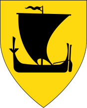
Coat-of-arms
The coat-of-arms is from modern times; they were granted in 1990. The arms show a blue-colored Anthony's cross on a silver background. The Anthony's cross is a canting of the letter T for Tjeldsund.
Churches
The Church of Norway has one parish (sokn) within the municipality of Tjeldsund. It is part of the Ofoten deanery in the Diocese of Sør-Hålogaland.
| Parish (Sokn) | Church Name | Location of the Church | Year Built |
|---|---|---|---|
| Tjeldsund | Tjeldsund Church | Hol i Tjeldsund | 1863 |
| Fjelldal Chapel | Fjelldal | 1960 | |
| Ramsund Chapel | Ramsund | 1964 |
Geography

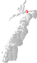
Tjeldsund is located in Nordland county on the border with Troms county. Tjeldsund is mostly located on the island of Tjeldøya which is surrounded by the Ofotfjorden on the south, the Tjeldsundet strait to the west and north, and the Ramsundet strait to the east. The island is connected to the mainland by the Ramsund Bridge. The rest of the municipality is a small area on the mainland to the east of Tjeldøya and a small area on the island of Hinnøya to the north of Tjeldøya. The municipalities of Evenes (in Nordland) and Skånland (in Troms) lies to the east of Tjeldsund, Harstad and Kvæfjord (in Troms) lie to the north, Lødingen to the west, and Ballangen to the south.

Climate
| Climate data for Hol i Tjeldsund | |||||||||||||
|---|---|---|---|---|---|---|---|---|---|---|---|---|---|
| Month | Jan | Feb | Mar | Apr | May | Jun | Jul | Aug | Sep | Oct | Nov | Dec | Year |
| Daily mean °C (°F) | −3.8 (25.2) |
−3.5 (25.7) |
−1.8 (28.8) |
1.5 (34.7) |
6.3 (43.3) |
9.9 (49.8) |
12.3 (54.1) |
11.8 (53.2) |
7.9 (46.2) |
3.9 (39) |
−0.2 (31.6) |
−2.7 (27.1) |
3.5 (38.3) |
| Average precipitation mm (inches) | 101 (3.98) |
91 (3.58) |
74 (2.91) |
61 (2.4) |
49 (1.93) |
54 (2.13) |
76 (2.99) |
81 (3.19) |
100 (3.94) |
141 (5.55) |
102 (4.02) |
115 (4.53) |
1,045 (41.14) |
| Source: Norwegian Meteorological Institute[4] | |||||||||||||
Government
All municipalities in Norway, including Tjeldsund, are responsible for primary education (through 10th grade), outpatient health services, senior citizen services, unemployment and other social services, zoning, economic development, and municipal roads. The municipality is governed by a municipal council of elected representatives, which in turn elect a mayor.
Municipal council
The municipal council (Kommunestyre) of Tjeldsund is made up of 17 representatives that are elected to every four years. Currently, the party breakdown is as follows:[5]
| Party Name | Name in Norwegian | Number of representatives | |
|---|---|---|---|
| Labour Party | Arbeiderpartiet | 5 | |
| Progress Party | Fremskrittspartiet | 2 | |
| Conservative Party | Høyre | 5 | |
| Centre Party | Senterpartiet | 2 | |
| Local Lists | Lokale lister | 3 | |
| Total number of members: | 17 | ||
References
- ↑ "Navn på steder og personer: Innbyggjarnamn" (in Norwegian). Språkrådet. Retrieved 2015-12-01.
- ↑ Jukvam, Dag (1999). "Historisk oversikt over endringer i kommune- og fylkesinndelingen" (PDF) (in Norwegian). Statistisk sentralbyrå.
- ↑ Store norske leksikon. "Tjeldsund" (in Norwegian). Retrieved 2012-06-11.
- ↑ "eKlima Web Portal". Norwegian Meteorological Institute.
- ↑ "Table: 04813: Members of the local councils, by party/electoral list at the Municipal Council election (M)" (in Norwegian). Statistics Norway. 2015.
External links
| Wikimedia Commons has media related to Tjeldsund. |
 Nordland travel guide from Wikivoyage
- Municipal fact sheet from Statistics Norway