Tiruvarur district
| Thiruvarur district திருவாரூர் மாவட்டம் | |
|---|---|
| District | |
|
| |
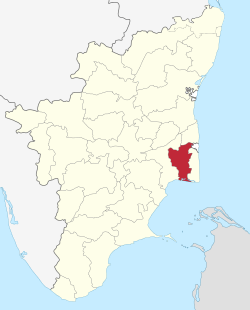 Location in Tamil Nadu, India | |
| Coordinates: 10°46′17.76″N 79°38′12.48″E / 10.7716000°N 79.6368000°ECoordinates: 10°46′17.76″N 79°38′12.48″E / 10.7716000°N 79.6368000°E | |
| Country |
|
| State | Tamil Nadu |
| Municipal Corporations | Thiruvarur |
| Headquarters | Thiruvarur |
| Talukas | Kudavasal, Mannargudi, Nannilam, Needamangalam, Thiruthuraipoondi, Thiruvarur, Valangaiman. |
| Government | |
| • Collector | M.Mathivanan, IAS |
| Population (2011) | |
| • Total | 1,264,277 |
| Languages | |
| • Official | Tamil |
| Time zone | IST (UTC+5:30) |
| PIN | 610xxx |
| Telephone code | 04366 |
| Vehicle registration | TN-50(6 Taluks),TN-68(Valangaiman Taluk) |
| Website |
tiruvarur |
Thiruvarur district (Composite Tanjore Dist) is one of the 32 districts in the Tamil Nadu state of India. The district occupies an area of 2161 km². It lies between Nagapattinam district on the east and Thanjavur District on the west, and is bounded by the Palk Strait on the south. The district headquarters is at Thiruvarur town. As of 2011, the district had a population of 1,264,277 with a sex-ratio of 1,017 females for every 1,000 males.
Demographics
According to 2011 census, Thiruvarur district had a population of 1,264,277 with a sex-ratio of 1,017 females for every 1,000 males, much above the national average of 929.[1] A total of 121,973 were under the age of six, constituting 62,280 males and 59,693 females. Scheduled Castes and Scheduled Tribes accounted for 34.08% and .24% of the population respectively. The average literacy of the district was 74.86%, compared to the national average of 72.99%.[1] The district had a total of 327,219 households. There were a total of 540,168 workers, comprising 60,508 cultivators, 200,126 main agricultural labourers, 7,264 in house hold industries, 144,527 other workers, 127,743 marginal workers, 9,375 marginal cultivators, 95,062 marginal agricultural labourers, 3,176 marginal workers in household industries and 20,130 other marginal workers.[2]
History
The Thiruvarur district, along with the Nagapattinam district was part of the Thanjavur District before 1991. After that, the present Taluks of Thiruvarur district and Nagapattinam district were separated from the Thanjavur District, and formed the Nagapattinam district. The present Thiruvarur district was formed in 1997 by trifurcating the then Thanjavur District.[3] Major towns are Thiruvarur, Thiruthuraipoondi, Nachikulam, Muthupettai, Mannargudi.
Administration
Thiruvarur district is made up of seven taluks:
References
- 1 2 "Census Info 2011 Final population totals". Office of The Registrar General and Census Commissioner, Ministry of Home Affairs, Government of India. 2013. Retrieved 26 January 2014.
- ↑ "Census Info 2011 Final population totals - Thiruvarur district". Office of The Registrar General and Census Commissioner, Ministry of Home Affairs, Government of India. 2013. Retrieved 26 January 2014.
- ↑ Mohan, Gopu (5 April 2011). "Boyhood friend waits for CM to come home". The Financial Express. p. 3.
External links
| Wikimedia Commons has media related to Tiruvarur (district). |
| State symbols |
|
|---|---|
| Governance |
|
| Topics | |
| Districts |
|
| Major cities | |
| District Headquarters |  | |
|---|---|---|
| Country | ||
| State | ||
| Region | ||
| Divisions | ||
| Taluks | ||
| Revenue blocks | ||
| Municipalities | ||
| Rivers | ||
| History | ||
| Places of interest |
| |
| Universities | ||
| ||