Tin Shui Wai
| Tin Shui Wai New Town 天水圍新市鎮 | |
|---|---|
|
Tin Shui Wai Sports Ground | |
| SAR |
|
| District | Yuen Long District |
| Established | 1993 |
| Area | |
| • Total | 4.3 km2 (1.7 sq mi) |
| Population (2014) | |
| • Total | 292,000 |
| • Density | 67,906/km2 (175,880/sq mi) |
| Website | Yuen Long District Council |
| Mean solar time UTC+08 | |
| Tin Shui Wai New Town | |||||||||||
| Traditional Chinese | 天水圍新市鎮 | ||||||||||
|---|---|---|---|---|---|---|---|---|---|---|---|
| Simplified Chinese | 天水围新市镇 | ||||||||||
| Literal meaning | Sky Water Walled Village New Town | ||||||||||
| |||||||||||
Tin Shui Wai New Town is located in the northwestern New Territories of Hong Kong. Originally a gei wai fish pond area, it was developed in the 1980s as the second new town in Yuen Long District and the eighth in Hong Kong. It is situated 25 kilometres due northwest of Central, Victoria, Hong Kong on land reclaimed from low-lying areas south of Deep Bay, next to historic Ping Shan. As of 2014, the new town had a population of 292,000, while the total projected population for when the town is fully built-out is about 306,000.[1]
History

The land on which Tin Shui Wai was built did not exist at the beginning of the 1900s, while the adjacent Ping Shan was by the sea. The water north of Ping Shan gradually turned to marshes and villagers converted it into pools and rice paddies. The pools became gei wai fish ponds where most of the residents were fishermen before the new town was developed. With the decline in aquaculture, most of the fish ponds were abandoned. The Hong Kong Government developed the area into a new town through land reclamation.
The new town, conceived in 1987 to house 140,000 people, was constructed on 2.4 square kilometres of reclaimed fishponds and wetland representing one quarter of the flat land in the New Territories.[2] The process of land reclamation for the new town was completed in 1990.[3] Formation of the 2.4 km2 was estimated to cost HK$820 million in a contract signed with a Chinese joint-venture company. 20 million cubic metres of material would be required for the landfill. Maximum possible land formation was 4.88 km2.[4]
A new modular style of construction for the public housing estates allowed rapid development and, in a first for a new town, on 26 March 1993 Tin Shui Wai was officially opened by Governor Chris Patten. By that time, some 30,000 people were already living there.[3]
The Government was accused by the developers of stalling the release of land for political reasons. Tin Shui Wai Development, a company 51% owned by China Resources and 49% by Cheung Kong Holdings, sued the Government for damages caused by delays in handing over 388,000 m² of land for development originally promised for 1985. The land was eventually handed over in May 1989.[2]
The first occupants moved into the new town in 1991.[4] The Housing Authority launched 6,459 Home Ownership Scheme flats in the area at steep discounts to an adjacent private estate, and attracted some 90,000 applications.[5]
The Development Zone of 220 hectares, located in the southern part of the new town, has been developed to house about 200,000 people. An LRT line and new roads linking the new town to the trunk road network provide good connections to the Yuen Long and Tuen Mun districts and to the urban areas beyond.
Further expansion of the new town into the remaining areas to the north, known as the Reserve Zone, with an area of 210 hectares, commenced in July 1998. The infrastructure was completed in stages from 2000 to 2004 to cope with population intake of the housing developments. West Rail and the extension of the LRT service to the Reserve Zone were also commissioned in late 2003. To the northeastern portion of the new town, a constructed wetland has been completed which serves as a buffer between the developments in the Reserve Zone and the Mai Po Nature Reserve. The constructed wetland has been further developed into the Hong Kong Wetland Park, opening to public in May 2006. The total planned population of Tin Shui Wai new town is about 306,000 while the current population is about 292,000.[6]
Environment

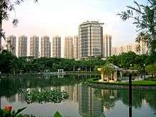
Parts of Tin Shui Wai have a picturesque and tranquil environment. The Hong Kong Wetland Park, demonstrating the diversity of the Hong Kong's wetland ecosystem, is located in north Tin Shui Wai.
Tin Shui Wai consists of both public and private housing estates. Tin Wah Road separates the south and the north development zones of Tin Shui Wai. The south development zone first started in the early 1990s, and has since become a unique community. Since Tin Shui Wai was planned and developed from scratch, locals enjoy wider walkways and larger open areas when compared to other urban developments in Hong Kong.
Following the completion of the north development zone, the government planned to build 85,000 units and apartments annually in Hong Kong after 1997. As such, the north development zone has residential apartment buildings that are generally taller and denser than those in the south zone. The population of Tin Shui Wai rose rapidly over the last part of the century, but has since stabilised. The government has been criticised for maintaining insufficient level of services and facilities to meet the rapid population growth in Tin Shui Wai.
Social issues
In recent years, the town acquired a rather dubious reputation in Hong Kong for being an area where numerous serious family and social issues, including domestic violence, mental illness, and suicide occurs. The collective suicide of three girls through coal burning took place, attracting extensive reports from the local media. According to some social workers, Tin Shui Wai is prone to family tragedies because of its remote location, limited employment opportunities, and high density of public housing estates.[7] Some also argue that the large number of new immigrants from Mainland China in the area, struggling to adjust to the different cultural and social dynamics of Hong Kong, also contributes to the problem.
A number of incidents and personal tragedies have occurred in the town. In 2003, a mainland woman, who had sought help from both social services and the police, and her twin daughters were stabbed to death by her husband who then fatally wounded himself.[8] In April 2004, a man killed himself after stabbing his 31-year-old mainland wife and two teenage daughters to death in their flat in Tin Shui Wai.[9] The accumulation of events caused the Director of Social Welfare, Mrs. Carrie Lam, to label Tin Shui Wai "City of Misery" (悲情城市) in July 2006. Lam's comment was criticised because it did nothing to solve the social problem within the town[10]
In October 2007, Mak Fu-tai, a 36-year-old woman suffering from mental illness bound the hands and feet of her 12-year-old daughter and nine-year-old son, and threw them out of a window in their 24th floor flat at Yiu Fung House, and then jumped to her death. Mak's husband, also with a history of mental illness, was hospitalised with terminal cancer. The deaths spurred a review of the inadequate social services provision.[11] This spurred some 20 non-governmental organisations to plead with the Legislative Council's welfare panel for more resources to deal with the problems there.[7]
On November 25, 2007, numerous residents rallied outside government headquarters to push for more aid and reform for the area. Many demanded the government to create new hospitals, jobs, and increase police enforcement in the town.[12]
Sights

The new town is centred on the Tin Shui Wai Park, which offers many gardens and activities.
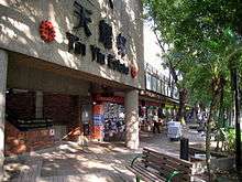
The Tin Sau Bazaar is a local marketplace in the northern part of the town managed by the Tung Wah Group of Hospitals.
Parts of Tin Shui have a picturesque and tranquil environment. The Hong Kong Wetland Park, demonstrating the diversity of Hong Kong's wetland ecosystem, is located in Tin Shui Wai. The 705 and 706 light rail stop at Wetland Park Stop.
Public facilities
Tin Shui Wai has two public swimming pools and two public libraries, Ping Shan Tin Shui Wai Public Library and Tin Shui Wai North Public Library.
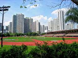
The largest sports ground is the Tin Shui Wai Sports Ground, a stadium with a capacity of 2,500 spectators. It also has a 400-metre running track. There are other football/rugby pitches at Tin Sau Road Park and Tin Yip Road Park in the northern part of the town.
The Tin Shui Wai Hospital is under construction.
There are four indoor sports centre in Tin Shui Wai. They are Tin Shui Wai Sports Centre, Tin Shui Sports Centre, Tin Fai Sports Centre and Ping Shan Tin Shui Wai Sports Centre. Also, there is a outdoor sports area in Tin Sau Road for volleyball, basketball and football court.
Also, Tin Sau Bazaar has opened in Tin Sau Road since 2013 Feb.
Housing

The main residences of Tin Shui Wai are the public housing estates and the 58 residential blocks of Kingswood Villas.
Public estates
- Grandeur Terrace (俊宏軒)
- Tin Chak Estate (天澤邨)
- Tin Ching Estate (天晴邨)
- Tin Heng Estate (天恆邨)
- Tin Shui (I) Estate (天瑞(一)邨)
- Tin Shui (II) Estate (天瑞(二)邨)
- Tin Tsz Estate (天慈邨)
- Tin Wah Estate (天華邨)
- Tin Yan Estate (天恩邨)
- Tin Yat Estate (天逸邨)
- Tin Yiu (I) Estate (天耀(一)邨)
- Tin Yiu (II) Estate (天耀(二)邨)
- Tin Yuet Estate (天悅邨)
Home Ownership Scheme estates
- Tin Chung Court (天頌苑)
- Tin Fu Court (天富苑)
- Tin Oi Court (天愛苑)
- Tin Lai Court (天麗苑)
- Tin Shing Court (天盛苑)
- Tin Yau Court (天祐苑)
Private housing estates
- Central Park Towers (柏慧豪園)
- Kingswood Villas (嘉湖山莊) – one of the largest private housing estates in Hong Kong
- Chestwood Court (翠湖居)
- Kenswood Court (景湖居)
- Maywood Court (美湖居)
- Lynwood Court (麗湖居)
- Sherwood Court (賞湖居)
- Locwood Court (樂湖居)
- Vianni Cove (慧景軒)
Education

- Primary schools
- Buddhist TCFS Yeung Yat Lam Memorial School - special-needs school for intellectual disability
- Caritas Lok Kan School - special-needs school for intellectual disability
- Chinese YMCA Primary School
- Chiu Yang Por Yen Primary School
- Chiu Yang Primary School of Hong Kong
- Christian Alliance S. Y. Yeh Memorial Primary School
- Cumberland Presbyterian Church Yao Dao Primary School
- Gigamind English Primary School
- Ho Ming Primary School Sponsored by Sik Sik Yuen
- Secondary schools
- Chinese YMCA Secondary School
- HKFYG Lee Shau Kee College
- Kung Yik She Secondary School
- Shun Tak Fraternal Association Yung Yau College
- Tin Shui Wai Government Secondary School
- Tin Shui Wai Methodist College
- YLPMSAA Tang Siu Tang Secondary School
Transport
Commuter railway

The town is served by Tin Shui Wai Station on the West Rail Line. The station borders the south of the town, near Ping Shan, and is adjacent to Tin Yiu Estate, Tin Shing Court and Tin Yau Court. It is elevated over the junction of Ping Ha Road and Tin Fuk Road. Several bus stops serve the station. Three footbridges are constructed along Tin Fuk Road and Ping Ha Road to connect the station to the town. The West Rail Line directly connects Tin Shui Wai to the neighbouring new towns of Tuen Mun and Yuen Long, as well as Tsuen Wan and Kowloon via the 5.5 kilometre Tai Lam Tunnel.
The entrances/exits of the station are:
- A: Public transport interchange, Hang Mei Tsuen
- B: Tin Shing Court, Tin Shui Wai Police Station
- C: Tin Yiu Light Rail Stop, Tin Yiu Estate
- D: Tin Yau Court, Tin Tsz Estate
- E1: Tin Shui Wai Light Rail Stop (Platform 1)
- E2: Tin Shui Wai Light Rail Stop (Platform 2)
- E3: Tin Shui Wai Light Rail Stop (Platform 3), Pagoda, Ping Shan Heritage Trail, Sheung Cheung Wai
Light railway
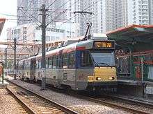
The district is also served by the Light Rail, with Tin Shui Wai Station serving as the main interchange point for the local branch of this network, which runs in a circle around the new town, called Tin Shui Wai Circular. The light rail network, in conjunction with the West Rail Line, connects the townships of Tuen Mun and Yuen Long. The light rail is divided into fare zones 1, 2, 3, 4, 5, and 5A. All of Tin Shui Wai's 16 light rail stops fall within zones 4 and 5A.
The Tin Shui Wai Stop of the Light Rail network belongs to Zone 4 for single-ride ticket. It is located underneath the West Rail station at ground level. Platforms 1, 2 and 3 can be reached by escalators at West Rail exits E1, E2 and E3, respectively.
Routes
| Route | Destination | Tin Shui Wai Station platform |
|---|---|---|
| 705 | Tin Shui Wai Circular (Anti-clockwise) | 1 |
| 706 | Tin Shui Wai Circular (Clockwise) | 3 |
| 751 | Yau Oi | 3 |
| 751 | Tin Yat | 2 |
| 761P | Yuen Long | n/a |
| 761P | Tin Yat | n/a |
Bus and road
A well-developed bus network is also an important transport element in Tin Shui Wai, with buses running to most major destinations in Hong Kong.
Main roads connecting the township to surrounding areas are Ping Ha Road, Tin Ha Road, Long Tin Road, Yuen Long Highway and Tin Wah Road (to Lau Fau Shan).
See also
Notes and references
- ↑ "Tin Shui Wai New Town". Civil Engineering and Development Department. 7 July 2014. Retrieved 5 August 2015.
- 1 2 Ng Kang-ching, "Developers sue over delay, The Standard, May 22, 1990
- 1 2 Serjeant, John (26 March 1993). "Official opening is a New Town first". South China Morning Post.
- 1 2 $820m new town deal will give homes to 140,000, Maureen Fan, South China Morning Post, October 27, 1987
- ↑ Ng Kang-ching, Big rush for new release of HOS flats, South China Morning Post, December 18, 1991
- ↑ CEDD - About Us
- 1 2 Carol Chung, "`Town of sadness' pleads for help", The Standard, October 31, 2007
- ↑ Carol Chung, "Mother, baby saved from suicide attempt", The Standard, November 10, 2007
- ↑ Marco Lui and Daniel Pang, "Father, child in murder-suicide", The Standard, July 09, 2007
- ↑ 天水圍vs「悲情城市, Wen Wei Po, July 18, 2006 (Chinese)
- ↑ Scarlett Chiang, "Tragic deaths spur action on mental health", The Standard, October 16, 2007
- ↑ "Residents in Hong Kong's 'City of Sadness' march for better social services". International Herald Tribune. 2007-11-25. Retrieved 2007-11-25.
External links
| Wikimedia Commons has media related to Tin Shui Wai. |
- Tin Shui Wai New Town
- A study of Tin Shui Wai New Town, Department of Social Work and Social Administration, University of Hong Kong. January 2009
- Wetland Park
Coordinates: 22°27′39″N 114°00′04″E / 22.4608°N 114.0012°E