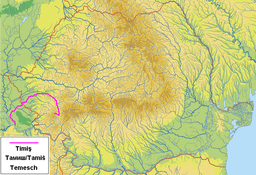
Timiș River
| Timiș Tamiš (Тамиш) | |
| River | |
 The Timiș (Tamiš) river near Pančevo | |
| Countries | Romania, Serbia |
|---|---|
| Counties/Province | Caraș-Severin, Timiș, Vojvodina |
| Tributaries | |
| - left | Bârzava/Brzava |
| - right | Bistra |
| Towns | Caransebeș, Lugoj, Pančevo |
| Source | Confluence of headwaters Brebu, Grădiștea and Semenic in Lake Trei Ape |
| - location | Semenic Mountains, Romania |
| Mouth | Danube |
| - location | near Pančevo, Serbia |
| - coordinates | RO 44°50′53″N 20°38′08″E / 44.84806°N 20.63556°ECoordinates: RO 44°50′53″N 20°38′08″E / 44.84806°N 20.63556°E |
| Length | 359 km (223 mi) |
| Basin | 10,280 km2 (3,969 sq mi) |
| Discharge | for * |
| - average | 47 m3/s (1,660 cu ft/s) |
| Progression | Danube→ Black Sea |
 | |
The Timiș or Tamiš (Romanian: Timiș; Serbian: Тамиш or Tamiš; German: Temesch; Hungarian: Temes) is a 359 km (223 mi)[1] long river originating from the Semenic Mountains (1,410 m (4,630 ft)), southern Carpathian Mountains, Caraș-Severin County, Romania. It flows through the Banat region and flows into the Danube near Pančevo, in northern Serbia.
Name
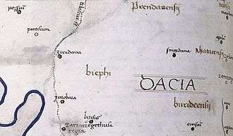
In antiquity, the river was known as Tibiscus (in latin) and Tibisis (Θίβισις in ancient Greek); in addition, Edward Gibbon referred to it as the Teyss.
The Romans, who traversed the plains of Hungary, suppose that they passed several navigable rivers, either in canoes or portable boats; but there is reason to suspect that the winding stream of the Teyss, or Tibiscus, might present itself in different places under different names. [2]
Characteristics
The drainage area covers 10,280 km2 (3,970 sq mi).[1] With the Danube, it belongs to the Black Sea drainage basin. The river flows through Romania for 241 km (150 mi), and 118 km (73 mi) through Serbia.
The river starts at the confluence of headwaters Brebu, Grădiștea and Semenic in Lake Trei Ape.
After entering Banat, the river becomes slow and meandering.
In its lower course, the river is regulated, and for the last 53 km (33 mi) it is navigable. The most important port is the heavily industrialized Pančevo.
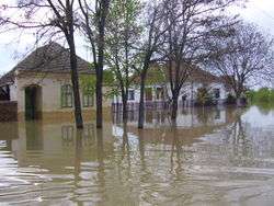
Flooding
After Banat, floods occur in rainy years. Especially devastating were the floods of 2005, when the villages Boka and Jaša Tomić were badly damaged. On April 20, 2005, a level of 844 centimeters (332 in) was recorded, the highest ever since the measurements began.
In the spring of 2007 works on the elevation of the embankments on the both sides of the river began, 11.5 kilometers (7.1 mi) on the right bank and 13.2 kilometers (8.2 mi) on the left. The embankments will be 30–70 cm (12–28 in) higher than they are now and being higher than 8.5 m (28 ft) should prevent any future floodings.[3]
In some parts of the low, marshy areas created by the floods, several fish-filled lakes have been created, most notably at Banatski Despotovac, Uzdin, Sakule and Slatina.
Tributaries
The following rivers are tributaries to the river Timiș:
Left: Brebu, Slatina, Goleț, Bucoșnița, Cernețu, Petroșnița, Valea Mare, Vălișoara, Măcicaș/Rugiu, Mâtnic, Vâna Mare, Spaia, Știuca, Timișana, Șurgani, Pogăniș, Timișul Mort, Găvojdia, Lanca Birda, Bârzava/Brzava
Right: Grădiște, Semenic, Teregova, Criva, Râul Rece, Râul Lung, Armeniș, Sadovița, Ilova, Groapa Copacului, Bolvașnița, Zlagna, Sebeș, Valea Mare, Bistra, Calova, Maciovița, Vălișorul, Tincova, Cernola, Nădrag, Slatina, Măguri, Tapia, Iarcoș, Timișaț
Settlements
Romania
Major cities in its Romanian course are Caransebeș and Lugoj, smaller places include (from source to mouth):
- Teregova, Armeniș, Slatina-Timiș, Bucoșnița, Buchin, Caransebeș, Constantin Daicoviciu, Sacu, Gavojdia, Lugoj, Coșteiu, Moșnița Nouă, Șag, Parța, Peciu Nou
Timișoara has its name derived from the river Timiș meaning the fortress of Timiș. However the town of Timiș City, even though its name may indicate it, is not a settlement on the river, but on another Romanian-Serbian river, Bega.
Serbia
From source to mouth: Jaša Tomić, Šurjan, Boka, Sečanj, Neuzina, Banatski Despotovac, Botoš, Tomaševac, Orlovat, Uzdin, Idvor, Farkaždin, Sakule, Čenta, Baranda, Opovo, Sefkerin, Glogonj, Jabuka, Pančevo
Pančevački Rit
The river's old mouth into the Danube was some 40 km (25 mi) to the north-west, between villages of Čenta and Surduk, thus it was shorter. Canal Karaš (Cyrillic: Караш) remained marking old river bed, and the area bounded by the old and new river beds and the Danube, is called Pančevački Rit (Marches of Pančevo, Cyrillic: Панчевачки Рит). The 400 km2 (150 sq mi) large wetland was constantly flooded, but since World War II it has been drained part by part and almost half of it is turned into a very fertile patch of land, suitable especially for cultivating grains and vegetables. It is managed by Serbian largest agricultural company, "PKB Beograd", which almost exclusively provides food for 2 million people in wider Belgrade area, thus Pančevački Rit is commonly nicknamed Granary of Belgrade. Stockbreeding is also very intensive, and so are fishery and hunting.
Many meandering canals and bogs remained in the marsh: slow streams of Vizelj, Dunavac, Sibnica, Butuš, Rogoznica, Buk, Belanoš and Sebeš, and large bogs of Reva, Veliko Blato (2 km2 (0.77 sq mi)), Sebeš and Široka bara. In the south, area ends with a river island (ada) Kožara (0.44 km2 (0.17 sq mi)).
After being almost uninhabited before 1945, today its population density is above average for Serbia as a whole, since some of the fastest growing suburbs of Belgrade (Borča, Padinska Skela and Krnjača) are built there. The whole area of Pančevački Rit belongs administratively to Belgrade's municipality of Palilula.
References
General references
- Mala Prosvetina Enciklopedija, Third edition (1985); Prosveta; ISBN 86-07-00001-2
- Jovan Đ. Marković (1990): Enciklopedijski geografski leksikon Jugoslavije; Svjetlost-Sarajevo; ISBN 86-01-02651-6
- Administrația Națională Apelor Române – Cadastrul Apelor – București
- Institutul de Meteorologie și Hidrologie – Rîurile României – București 1971
- Trasee turistice – județul Timiș
Maps
- Harta județului Timiș
- Harta Munții Poiana Rusca
- Harta Munții Țarcu/Muntele Mic
- Harta Județului Caraș-Severin
| Countries |  | |
|---|---|---|
| Cities | ||
| Tributaries | ||
| See also | ||