Tile Hill Wood
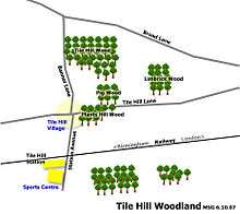
Tile Hill Wood is a wood between Hawthorn Lane and Banner Lane in the Tile Hill area of Coventry, England. It has been designated as a Site of Special Scientific Interest[1][2] and a Local Nature Reserve.[3][4] It is stewarded by the Coventry and District Natural History and Scientific Society. It is a mixed deciduous and coniferous woodland covering 69.92 acres (28.30 ha), with examples of Norway Spruce, European Larch and Hazel coppice, together with Sycamore, Oak, Spruce, Birch, Chestnut, Ash and Pine.[5]
There are specially-built paths suitable for people with disabilities (660 m). These have metal tap rails for people with visual impairment.
From 1930, Coventry Corporation established the wood as a Nature Reserve and it had a regular forester assigned to it.[6] Rides were kept clear and the removal of waste was carried out by horse and cart rather than by tractor or lorry. During the Second World War, large areas of scrub and conifers were cleared to reduce the risk of fire from air-raids.[5] During the cyclonic gale of March 1947, five acres (2 ha) of mature spruce were uprooted. These were replaced with young trees over several years, and helped to alter the ecological balance of the reserve.[5]
The wood received SSSI status in 1952. The status was renewed in 1986 under the Wildlife and Countryside Act of 1981.[7]
References
- ↑ "Tilehill Wood citation" (PDF). Sites of Special Scientific Interest. Natural England. Retrieved 26 July 2013.
- ↑ "Map of Tilehill Wood". Sites of Special Scientific Interest. Natural England. Retrieved 26 July 2013.
- ↑ "Tile Hill Wood". Local Nature Reserves. Natural England. Retrieved 26 July 2013.
- ↑ "Map of Tile Hill Wood". Local Nature Reserves. Natural England. Retrieved 26 July 2013.
- 1 2 3 "Tile Hill Woodlands". Coventry Walks. July 2003. Retrieved 14 February 2008.
- ↑ British Ecological Society (1937). The Journal of Animal Ecology. Blackwell Science. p. 414.
- ↑ "Tile Hill Wood Nature Reserve - a brief history". Coventry & District Natural History & Scientific Society. Retrieved 14 February 2008.
Coordinates: 52°24′22″N 1°35′20″W / 52.406°N 1.589°W