Tidcombe

Coordinates: 51°19′23″N 1°35′06″W / 51.323°N 01.585°W
Tidcombe is a small village in Wiltshire, England, on the eastern edge of the county, near Hampshire. It is about 9 miles (14 km) southeast of Marlborough and 7 miles (11 km) southwest of Hungerford, Berkshire. With few inhabitants, it forms part of the civil parish of Tidcombe and Fosbury, which has a parish meeting.[1]
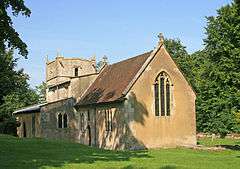
There is evidence of a church in the mid 13th century.[2] The Anglican Church of St Michael has a 17th-century tower and is Grade II* listed.[3] Tidcombe manor house, from the mid to late 18th century, is also Grade II* listed.[4]
On both sides of the parish boundary with Fosbury lies the Iron Age hill fort of Fosbury Camp.
References
- ↑ "Tidcombe & Fosbury". Wiltshire Community History. Wiltshire Council. Retrieved 29 May 2015.
- ↑ "Victoria County History - Wiltshire - Vol 16 pp215-222 - Tidcombe". British History Online. University of London. Retrieved 29 May 2015.
- ↑ Historic England. "Church of St Michael, Tidcombe (1299891)". National Heritage List for England. Retrieved 29 May 2015.
- ↑ Historic England. "Tidcombe Manor (1365508)". National Heritage List for England. Retrieved 29 May 2015.
External links
![]() Media related to Tidcombe at Wikimedia Commons
Media related to Tidcombe at Wikimedia Commons
This article is issued from Wikipedia - version of the 7/7/2015. The text is available under the Creative Commons Attribution/Share Alike but additional terms may apply for the media files.