Thotupola Kanda
| Thotupola Kanda | |
|---|---|
|
Thotupola Kanda as seen from Pattipola railway station | |
| Highest point | |
| Elevation | 2,357 m (7,733 ft) |
| Coordinates | 06°49′59″N 80°49′11″E / 6.83306°N 80.81972°ECoordinates: 06°49′59″N 80°49′11″E / 6.83306°N 80.81972°E |
| Geography | |
 Thotupola Kanda | |
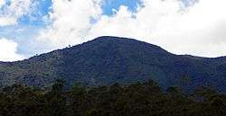
Thotupola Kanda, also sometimes referred as the Thotupola Peak or Thotupola Mountain, is the third highest mountain is Sri Lanka situated in Nuwara Eliya district 2,357 m (7,733 ft) above mean sea level. Mountain is placed within the Horton Plains National Park. About two kilometers long trail is there to the top of the mountain that starts few metres away from the Pattipola entrance to the Horton Plains National Park. Most part of the mountain surface is covered with shrubs adapted to the cool and windy climate of Horton Plains National Park. Strobilanthes,Osbeckia and Rhodomyrtus species grown as shrubs are common among them.
Legend
Thotupola Kanda has the meaning of ‘Landing Site’ in Sinhala language which related to a legend of Rama and Ravana. According to the legend, King of India, Rama and his beautiful wife Sita lived in exile in the jungle. Once Ravana kidnapped Rama’s wife Sita and escaped to Sri Lanka. On the way to Sri Lanka plane first landed in Thotupola Kanda which has the meaning of landing site. [1] [2]
See also
References
- ↑ "Thotupola Kanda Nature Trail – Horton Plains National Park". Sri Lanka Trail Guides 06. Lakdasun - Images of Sri Lanka.
- ↑ "Totupota (Thotupola) Kanda Travelogue (2359m) 3rd Highest Mountain in Sri Lanka". SRI LANKAN TRAVELLERS Travelogue Archive.
External links
| Wikimedia Commons has media related to Thotupola Kanda. |