Thorpe Park No 1 Gravel Pit
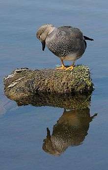
Thorpe Park No 1 Gravel Pit is a Site of Special Scientific Interest (SSSI) in Surrey, England. The designated SSSI status is as it is a habitat of gadwalls (Anas strepera, a quite large species in the main dabbling duck genus) as a wintering habitat and for the other wildfowl that winter there in small but regular numbers that include goldeneyes (Bucephala clangula) and smews (Mergus albellus).[1]
History
The gravel pits at Thorpe Park were developed by Ready Mixed Concrete Ltd in the 1930s for the extraction of both sand and gravel for use in construction. They were intentionally flooded in the 1970s when the site was re-purposed for recreational use.[2][3]
The site received its SSSI listing in 1999.[4] The British Trust for Ornithology noted a Wetlands Advisory Service report of 2003 that suggested recreational activities at the site might have contributed to a decline in recorded gadwall numbers.[5] The site is used for waterskiing but the activity is prohibited between 1 October - 31 March, which is the period when the gadwalls use it for feeding. At other times of the year, the number of participants is restricted.[6]
Citation
The designated SSSI status is as it is a habitat of Anas strepera as a wintering habitat and for the other wildfowl that winter there in small but regular numbers that include Bucephala clangula and the Mergus albellus.[1]
References
- 1 2 "Thorpe No. 1 Gravel Pit: Citation" (PDF). Natural England. Retrieved 2015-04-20.
- ↑ Nagle, Garrett (1999). Britain's Changing Environment. Nelson Thornes. p. 58. ISBN 978-0-17490-023-8.
- ↑ Arbogast, Belinda F.; Knepper, Daniel H.; Langer, William H. (2000). The Human Factor in Mining Reclamation. U.S. Geological Survey Circular. 1191. U.S. Geological Survey. p. 16. ISBN 978-0-60793-275-1.
- ↑ "Implications for Planning and Nature Conversation" (PDF). South West London Waterbodies Study. 2007: 14. Retrieved 2015-04-20.
- ↑ "BTO Research Report No. 361: South West London Waterbodies SPA Wildfowl Population Analysis" (PDF). British Trust for Ornithology: 9, 19. Retrieved 2015-04-20.
- ↑ "Appropriate Assessment Report" (PDF). Runnymede Council. March 2014: 7–8. Retrieved 2015-04-20.
Further reading
- Brigg, Brian (2007). "The use of waterbodies in South-West London by Gadwall and Shoveler; implications for nature conservation" (PDF). (University of Oxford PhD thesis)
External links
- "Surrey County Council Local Nature Reserves". Surrey County Council.
Coordinates: 51°24′06″N 0°31′07″W / 51.4017°N 0.5186°W