Thorpe, Surrey
| Thorpe | |
 The centre of the village occupies the extreme left of this aerial photograph showing the Thorpe Interchange of the two motorways passing through the edge of the village. |
|
 Conservation area scene: the church and preserved square |
|
 Thorpe |
|
| Population | 5,465 (2011 Census. Ward)[1] |
|---|---|
| OS grid reference | TQ019685 |
| District | Runnymede |
| Shire county | Surrey |
| Region | South East |
| Country | England |
| Sovereign state | United Kingdom |
| Post town | Egham |
| Postcode district | TW20 |
| Dialling code | 01932 |
| Police | Surrey |
| Fire | Surrey |
| Ambulance | South East Coast |
| EU Parliament | South East England |
| UK Parliament | Runnymede and Weybridge |
Coordinates: 51°24′25″N 0°32′07″W / 51.4069°N 0.5354°W
Thorpe is a village in Surrey, England, between Egham and Chertsey. It lies just inside the circle of the M25, near the M3, and its ward covers 856 hectares (2,120 acres). The River Bourne or Chertsey Bourne flows through the south of village. To the south-east of the village is Thorpe Park, one of England's largest theme parks, which is also a watersports centre. Its second-tier local authority, Runnymede, is a largely suburban area and Thorpe has never had a civil parish.
Geography
Land use
Thorpe is buffered by fields, lakes and woods to all sides (apart from its linear neighbourhood of Thorpe Green) leading to Virginia Water railway station. A very short frontage is provided in terms of borders, to the River Thames to the east, in favour of frontage of outskirts of the larger towns of Chertsey and Egham which border Thorpe to the south and north. Its former rural community partly remains following the construction of nearby motorways and gravel pit extraction. In particular buildings pre-dating 1850 form much of the core of the village centre which is a conservation area. Given the railway line and M25 in the far west of Thorpe, and the M3 to the south, much land use is designated road or buffer, and a considerable amount is taken up by one of the largest theme parks in England, Thorpe Park. This is also a watersports centre and one of its five main lakes can be accessed from boat landing stages from the village centre directly.
Elevations and soil
Elevations are modest but not flat, ranging between 14 and 20m Ordnance Datum as much of the area lies on thin alluvium overlying gravel beds laid over millennia by the River Thames which adjoins the traditional parish to the east.
This range of elevations is greater than central Chertsey but smaller than Egham (in particular to its two upper neighbourhoods or localities of Stroude and Egham Hill). A public road in the south of Thorpe has a wooded backdrop being at the foot of St Ann's Hill marking a north-western boundary of Chertsey.[2]
Localities
Thorpe Green
Thorpe Green is a relatively sparsely populated, almost rural neighbourhood that has a substantial recreation area and public house to one side of its sole developed road and private housing to the other.
Thorpe Lea
Thorpe Lea can be considered the southern suburb of Egham, with which it is contiguous along a long border with a number of interconnecting streets. Its housing stock was largely built shortly after the coming of railway in the early Victorian period at nearby Egham railway station.[2]
History
Archeological finds in the surrounds point to Bronze and Iron Age as well as Roman settlements. Chertsey Abbey records note a place of worship at Thorpe from the 7th century (seemingly on the same site); the chancel of the parish church was constructed as a chapel of retreat for the private use of Chertsey's Abbot and stands on Roman and pre-Roman foundations. The nave of the present church dates from the 10th century; millennium celebrations at St. Mary's took place in 1990. Accordingly, Thorpe lay in the Godley hundred, so-named for the national religious prominence of this abbey, and percentage of dues payable to it. Sizeable portions of the land of Godley hundred belonged to the medieval Roman Catholic church before the dissolution of the monasteries.
Thorpe appears in Domesday Book of 1086 as Torp. It was held by Chertsey Abbey. Its domesday assets were: 7 hides. It had 9 ploughlandss, 33 acres (13 ha) of meadow, herbage (typically woodland) worth 24 hogs. It rendered £12 per year.[3][4] Until the Inclosure Act 'privatised' them here,[5] approximately half of the parish lay in common fields.[6]
From the church a path known as the 'Monk's walk' ran as far as Chertsey abbey[6] until the mid-20th century.
- Manor
Having just parted from actual control of the abbey by a voluntary lease of 30 years in 1509, after approximately five centuries, Chertsey abbey lost the manor for good in 1537 when the abbot surrendered all of his lands to Henry VIII. From 1610, the family of Sir Francis Leigh (later Lord Chichester) owned the very large manor and the neighbouring later manor in the parish, Hall Place, with the exception of a period of 99 years when it saw a complex series of transactions which saw it profit instead Sir Francis Bacon, William Minterne and George Evelyn. Sir John Leigh's two heirs were his female cousins, Ann and Mary (who had the surname Leigh-Bennett). Her male issue went on to inherit the manor. Incidentally in her time as lady of the manor also the two estates were held by them jointly until the passing of an Act of Parliament, 7 Geo. III, chapter 7, by which the legal partition was effected.[6]
Landmarks
The village has 28 listed buildings (excluding any local listing) constructed using the materials and styles of the area.[7]
- St Mary's Church
St Mary's Church at Grade II*[8] is part of the conservation area along with a number of other listed buildings locally and nationally dating from the 17th century onwards. Renalds Herne, an 18th-century, brick-built house, stands almost opposite the parish church facing a picturesque close with a thatched cottage and adjacent to another 18th-century brick-built house with a brick-filled window, suggesting because of the long-standing window tax of the latter part of that century and early into the next.
- Thorpe House
This is the second of three buildings in the Grade II* category and is the only listed building on the north side of the main east-west road leading past the church. It is an ornate building chiefly of the 18th century (partly earlier and later). Thorpe House has walls made of stock brickwork with red brick dressings, an entablature front. Inside are moulded door architraves, many ornate features such as dado rails, marble and cast iron interiors.[9]
- The Cottage
This is the last of the three buildings in the Grade II* category and is 16th-century with 18th-century additions. Mostly of brick, it has a double timber post and is white-painted with black beams.[10]
Economy
Official statistics of the 2011 Census reveal that the most significant sectors of employment were Transport & Storage, and Education with 12% and 11% of the workforce respectively. Reflecting national statistics of suburban areas, 0.4% of the population worked in agriculture, forestry, fishing, mining or quarrying.[1] Across the less precise range of wide occupation categories, each had a considerable percentage of Thorpe employees; professional occupations was foremost among these, slightly higher than the next highest category, associate professional and technical occupations, followed by director or senior official level occupations.[1]
The village's most important landowner is Thorpe Park theme park, which is also a significant employer of the local population. Junctions of motorways providing fast links to London Heathrow airport are accessible in the outskirts of the two adjoining towns. The American School in Switzerland, (TASIS England) and golf resorts such as Wentworth provide other sources of employment; landscaping being significant in neighbouring Virginia Water and the closest part of Berkshire beyond this, which is Sunningdale.
Thorpe Industrial Estate/Business Park adjoining the village centre by Thorpe Park Lakes is home to Maranello Concessionaires, Ferrari's UK distributor.
Notable inhabitants
Notable former inhabitants of Thorpe include Frank Muir, David Williams and Admiral Hardy (1769–1839), captain of HMS Victory during the Battle of Trafalgar.
In 1909, H.E. Malden's edition of the Victoria County History described Thorpe as "picturesque and consists of a group of houses at the cross-roads, with others scattered along a winding road to the east." This volume noted the following homes and owners:
- Thorpe Place: Mr. Henry Currie Leigh-Bennett. (M.P. for Chertsey district 1897–1903) Site of the old manor house.
- Thorpe Lea : Lady Milford (née Lady Anne Jane Howard)
- Thorpe House: Mr. W. C. Scott (for building details see above)
- The Grange: Mr. E. H. Holden[6]
Gallery
 St Mary's Church. Earliest parts 7th-century with brick-built crenellated tower from the early 16th century, restoration in 1893
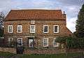 Renalds Herne, an 18th-century, brick-built house constructed of local materials to traditional local design
 St Mary's brick-built, early 16th-century tower (with later crenellation), diagonal buttresses and square-headed three pane window above wooden door
References
- 1 2 3 2011 Census data
- 1 2 Grid square map Ordnance survey website
- ↑ Surrey Domesday Book
- ↑ Domesday Map Retrieved 1 October 2013
- ↑ Inclosure Act. Statute 47 Geo. III, cap. 63
- 1 2 3 4 H.E. Malden (editor) (1911). "Parishes: Thorpe". A History of the County of Surrey: Volume 3. Institute of Historical Research. Retrieved 1 October 2013.
- ↑ OS Map with Listed Buildings and Parks marked
- ↑ St Mary's Church – Grade II* – Historic England. "Details from listed building database (1189962)". National Heritage List for England.
- ↑ Thorpe House – Grade II* – Historic England. "Details from listed building database (1190067)". National Heritage List for England.
- ↑ The Cottage – Grade II* -Historic England. "Details from listed building database (1378051)". National Heritage List for England.
External links
![]() Media related to Thorpe, Surrey at Wikimedia Commons
Media related to Thorpe, Surrey at Wikimedia Commons
| Towns, villages and neighbourhoods |
|  | ||||||||||||||
|---|---|---|---|---|---|---|---|---|---|---|---|---|---|---|---|---|
| Notable parks | ||||||||||||||||
| Churches | ||||||||||||||||
| Education | ||||||||||||||||
| Transport |
| |||||||||||||||
| Buildings and structures | ||||||||||||||||
| Sports |
| |||||||||||||||
Places listed are articles notable as settlements, arranged by post town | ||||||||||||||||