Thornton, Ontario
| Thornton, Ontario | |
|---|---|
| Hamlet | |
 | |
| Coordinates: 44°16′15″N 79°43′20″W / 44.27083°N 79.72222°W | |
| First Settled | 1820's |
| Established | 1854 |
| Elevation | 290 m (950 ft) |
| Population (2011 Census) | |
| • Total | 1,001 |
| Area code(s) | 705 |
The hamlet of Thornton is located in Essa, Ontario, Canada. It has a population of 1,001 as of the 2011 Census. It is about 74 kilometres (46 mi) north of Toronto.[1]
Geography
Thornton is located on generally flat and fertile soils about 9 kilometres (5.6 mi) north of Cookstown, Ontario, and 5 kilometres (3.1 mi) south of Barrie, Ontario. The Trans Canada Trail runs through Thornton and the intersection of Country Road 21 and County Road 27 marks the core of the hamlet of Thornton.
History
The town of Thornton developed during the 1820's, and in 1833 was established as Henrysville (or Henry's Corners) after early settler John Henry, who was the first teacher and then the schoolmaster, and later became the postmaster when an office opened in 1854. The name Henrysville caused confusion in the mail system at the time, so the community became Thornton in 1854 after Henry Thornton, who owned a grist mil, saw mill and planning mill.
Places in Thornton
Thornton is similar to most rural towns. Some places in Thornton are:
- A fire station. The fire station in Thornton is run by volunteers and is a municipal service that provides help in emergency situations, education about preventing fires from occurring, and fire permits. The fire station building is shared with Essa Public Library.[2]
- Essa Public Library. The Essa Public Library was founded in December 1996. It also has a meeting room for community events and activities and provides internet access to its clients.[3]
- Thornton Lions Club Office
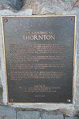 Thornton Historical Plaque
 - Thornton Crossing Plaza
- Thornton Arena. The Arena is home to the Thornton Tigers, a minor hockey league team.[4]
- Thornton Corner Store
- Vidya’s Veggie Gourmet Restaurant.[5] The historic brick building, also known as the Queen’s Hotel, was constructed in 1852.[6] The former steak-house reopened as a vegetarian restaurant in 2014. The historical building is also home to the Vidya Centre For Yoga And Wellness.[7]
- The Original Thornton Ice Cream Parlour & Café
- Architectural Health & Fitness
Recent developments
Thornton has had two subdivisions built within the hamlet in the last 10 years. The Thornton Crossing Plaza has also been built with a variety of businesses including the Thornton Post Office and a few private businesses.
References
Coordinates: 44°16′15″N 79°43′20″W / 44.27083°N 79.72222°W