Thompson Peak (Idaho)
| Thompson Peak | |
|---|---|
 Thompson Peak from near Stanley | |
| Highest point | |
| Elevation | 10,751 ft (3,277 m) NAVD 88[1] |
| Prominence | 2,431 ft (741 m) [2] |
| Coordinates | 44°08′30″N 115°00′36″W / 44.14153325°N 115.009968511°WCoordinates: 44°08′30″N 115°00′36″W / 44.14153325°N 115.009968511°W [1] |
| Geography | |
 Thompson Peak | |
| Parent range | Sawtooth Range |
| Topo map | USGS Stanley Lake |
| Climbing | |
| Easiest route | Scramble, class 3 |
Thompson Peak, at 10,751 feet (3,277 m) above sea level is the highest peak in the Sawtooth Range of Idaho. The summit of Thompson Peak is located within Custer County, although some of the lower portion of the mountain is in Boise County. Thompson Peak is also located within the Sawtooth Wilderness portion of the Sawtooth National Recreation Area, a unit of Sawtooth National Forest. The town of Stanley, Idaho is about 6 miles (9.7 km) northeast of Thompson Peak.[3]
Redfish Lake, Little Redfish Lake, and the visitor services at these locations are only a few miles from Thompson Peak. Directly to the north is neighboring Williams Peak, while Mickey's Spire is 0.24 miles (0.39 km) to the south-southwest.
There are a total of four routes to the top of Thompson Peak: South Couloir - class 3, Southwest Couloir - 5.2, Northeast Face - 5.8, West Crack - 5.2. The easiest way to access Thompson Peak is from the Redfish Lake trailhead and to take the Fishhook Creek Trail to the Alpine Way Trail. From there, follow the Alpine Way Trail to the base of Williams Peak before going off trail up to an unnamed lake to the northeast of Thompson Peak. Then, head up to the saddle between Thompson and Williams Peaks before making the class 3 scramble on the west-southwest side of the peak that begins on the Thompson-Mickey's Spire saddle.
 View from the summit
.jpg) Thompson Peak from Alpine Way Trail
Thompson Peak from Alpine Way Trail Thompson Peak from near Stanley Ranger Station
 Thompson Peak as seen from Alpine Way Trail
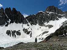 Thompson Peak from cirque below
References
- 1 2 "Goat". NGS data sheet. U.S. National Geodetic Survey. Retrieved 2010-02-15.
- ↑ "Thompson Peak, Idaho". Peakbagger.com. Retrieved 2010-02-15.
- ↑ Sawtooth National Forest. “Sawtooth National Forest” [map].1:126,720, 1”=2 miles. Twin Falls, Idaho: Sawtooth National Forest, United States Forest Service, 1998.
External links
- "Thompson Peak". Geographic Names Information System. United States Geological Survey. Retrieved 2010-02-15.
- Thompson Peak
- SummitPost.org - Thompson Peak
- Sawtooth National Forest - Official Site
- Thompson Peak Trip Report