Tiruvalla
| Tiruvalla തിരുവല്ല | |
|---|---|
| Municipal City | |
|
St. John's Cathedral, Tiruvalla | |
 Tiruvalla  Tiruvalla Location in India | |
| Coordinates: 9°23′06″N 76°34′30″E / 9.385°N 76.575°ECoordinates: 9°23′06″N 76°34′30″E / 9.385°N 76.575°E | |
| Country |
|
| State | Kerala |
| District | Pathanamthitta |
| Population (2011)[1] | |
| • Total | 52,883 |
| Languages | |
| • Official | Malayalam, English |
| Time zone | IST (UTC+5:30) |
| PIN | 689101 |
| Telephone code | 91-469 |
| Vehicle registration | KL-27 |
| Literacy | 98.5% |
| Nearest Airport | Cochin International Airport Limited |
| Website |
www |
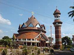
Tiruvalla (alternately spelled Thiruvalla, Malayalam: തിരുവല്ല or തിരുവല്ലാ, Hindi: तिरुवल्ला, Sanskrit: श्रीवल्लभपुरम्) is a city and also the headquarters of the Taluk of same name located in Pathanamthitta district in the State of Kerala in South India. The city is spread over an area of 27.94 km2; it is the biggest commercial centre in the district of Pathanamthitta. It lies on the banks of the rivers Manimala and Pamba, and is a land-locked region surrounded by irrigating streams and rivers.
Tiruvalla is regarded as the "cultural capital of Central Travancore", and also called "Land of non resident Indians".[2]
Demographics
The city spans a geographic area of 27.94 km² with a population of 56,828 as of 2001.[3] Males constitute 48% of the population and females 52%. In Tiruvalla, 10% of the population is under 6 years of age. Tiruvalla has a large Non-Resident Indian Community.
Location
Tiruvalla is on the western border of Pathanamthitta district. The municipal town limits are Thirumoolapuram, Kattod, Kaviyoor, Kuttoor, Kuttapuzha, Mepral and Chathenkary. Formerly, some areas of present Changanacherry were parts of Tiruvalla taluk. Now the boundaries of the taluk are Varattar Bridge in the south, Parumala in the south west, Lappalam in the north, Pullad in the east and Neerattupuram in the west, situated in Alappuzha district. Pullad is the last point of Tiruvalla in the east, and it is in the Koipuram panchayat. Kollam, Thiruvananthapuram and Kochi are the nearest major cities.
Tiruvalla is located at the meeting point of M C Road (Main Central Road/SH-01), the NH-220 and TK Road (Thiruvalla-Kumbazha Road) (Tiruvalla-Pathanamthitta-Kumbazha Road/SH-07/State Highway 7 (Kerala)); it links the eastern parts of the district with the western rice bowl of 'Kuttanad'. The Tiruvalla-Kayamkulam road is the most used link between the National Highway and the M C Road. Tiruvalla also connects to NH-47 through the Thakazhi-Ambalappuzha Link.
Transport
Road
Kerala State Road Transport Corporation has a depot at Tiruvalla (station code: TVLA) which is one among the 29 major depots in the state. KSRTC operates long distance and interstate bus services from the Tiruvalla depot. KSRTC operates daily Interstate Airbus service to Bangalore from Tiruvalla. KSRTC has built a new Bus Terminal with an integrated multi-functional shopping complex in Tiruvalla as part of its modernisation. Private buses operate from the Municipal Private Bus stand to various nearby places.
Rail

Tiruvalla railway station (station code: TRVL) is the sole railway station in Pathanamthitta district. The station is in the "Class A" category under the Trivandrum railway division. Tiruvalla railway station lies in Tiruvalla city, between the Chengannur railway station and Kottayam railway station in the Ernakulam - Kottayam - Kayankulam railway line. Tiruvalla is one of the oldest computerised stations of Kerala. It is a major railway station, and rail connects Tiruvalla with most of the major cities of India, like Bikaner, Bhopal, Bangalore, New Delhi, Chennai, Kolkata (Howrah), Guwahati, Rajkot, Ahmedabad, Hyderabad, and Mumbai.
Airport
The nearest airports are Cochin International Airport (105 km) and Trivandrum airport (126 km). The proposed rural Aranmula International Airport would be the closest airport upon completion, at 18 km away. Air India has a reservation office at Tiruvalla, the only one in the whole district.
Etymology
Traditionally, the name is taken to derive from the words Thiru Valla Vaay, the city being named after the river Manimala which was known as Vallayar. Tiruvalla was the mouth of the river Manimala and hence was known as Valla Vai(vai in old Malayalam means mouth [of a river]).[4] Another theory is that Thiruvallabha Puram (Land of Vallabhan, from Sree Vallabha, name of the presiding deity of the Tiruvalla Temple, the husband of Lakshmi Devi) became Tiruvalla.[4]
The Sanskrit name for Tiruvalla in texts such as "श्रीवल्लभ क्षेत्र माहात्म्यम्" (ശ്രീവല്ലഭ ക്ഷേത്ര മാഹാത്മ്യം, śrīvallabha kṣētra māhātmyaṁ,a 10th-century work) is "श्रीवल्लभपुरम्" (ശ്രീവല്ലഭപുരം)(śrīvallabhapuraṁ).[4]
Geography and climate
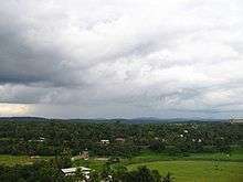
Tiruvalla city area lies at an altitude of 21 m above sea level, on the basin of the rivers Pamba and Manimala. Tiruvalla is dotted with several natural canal streams (called "thodu" in Malayalam) like Chanthathodu, Manippuzha, Mullelithodu, and several others. The city area has riverine alluvial soil, and eastern parts have a laterite loam kind of soil classified under "Southern Midlands" agro-ecological zone, while the western suburbs like Niranam have a more sandy type of soil that resembles beaches. (Kuttanad agro-ecological zone)[5] The reason for this is believed to be the older status of Niranam as a port, before reclamation of Kuttanad from the sea occurred. The Upper Kuttanad region in Tiruvalla has the "Karappadam" type of soil, which is clay loam in texture, has high organic matter, and is situated in areas about 1–2 m above sea level.[5]
The climate of Tiruvalla is tropical. There is significant rainfall in most months of the year. The short dry season has little effect on the overall climate. The Köppen-Geiger climate classification is Am. The temperature here averages 27.3 °C. In a year, the average rainfall is 2975 mm.[6]
| Climate data for Tiruvalla | |||||||||||||
|---|---|---|---|---|---|---|---|---|---|---|---|---|---|
| Month | Jan | Feb | Mar | Apr | May | Jun | Jul | Aug | Sep | Oct | Nov | Dec | Year |
| Average high °C (°F) | 31.3 (88.3) |
31.7 (89.1) |
32.7 (90.9) |
32.7 (90.9) |
32 (90) |
29.8 (85.6) |
29.8 (85.6) |
29.8 (85.6) |
30 (86) |
30 (86) |
30 (86) |
30.7 (87.3) |
30.88 (87.61) |
| Average low °C (°F) | 22.5 (72.5) |
23.4 (74.1) |
24.7 (76.5) |
25.4 (77.7) |
25 (77) |
23.9 (75) |
23.9 (75) |
23.8 (74.8) |
24 (75) |
23.8 (74.8) |
23.5 (74.3) |
22.6 (72.7) |
23.88 (74.95) |
| Average precipitation mm (inches) | 22 (0.87) |
35 (1.38) |
60 (2.36) |
155 (6.1) |
320 (12.6) |
596 (23.46) |
542 (21.34) |
372 (14.65) |
284 (11.18) |
326 (12.83) |
210 (8.27) |
54 (2.13) |
2,976 (117.17) |
| Source: http://en.climate-data.org/location/59916 | |||||||||||||
At an average temperature of 29.0 °C, April is the hottest month of the year. July has the lowest average temperature of the year. It is 26.4 °C. Between the driest and wettest months, the difference in precipitation is 574 mm. Precipitation is the lowest in January, with an average of 22 mm. With an average of 596 mm, the most precipitation falls in June.[6]
Due to proximity to the equator, Tiruvalla has very little variation in average temperature. During the year, the average temperatures vary by 2.6 °C.[6]
Tiruvalla has two monsoon seasons, the "Advancing monsoon season" during June through September, which is fed by the Southwest monsoon and the "retreating monsoon season", during October to December by the Northwest monsoon. Tiruvalla lies on the windward side of the western ghats, and thus receives maximum rainfall during the "advancing monsoon" season.
History
There is evidence to suggest that the area had been inhabited since 500 BCE, although an organized settlement only began around 800 CE. The present day areas of Niranam and Kadapra on the western part of Tiruvalla were submerged under the sea before then.[4] It is one of the 64 ancient Brahmin settlements (brahmana graamams, ബ്രാഹ്മണഗ്രാമം).
Stone axes from the Neolithic Age have been reported from Tiruvalla.[7] Ptolemy mentions the Baris river, the present "Pamba" river near the city.[8]
Education
The Tiruvalla has been an active centre of education since the age of "Tiruvalla sala" from 11th century onwards. The first higher secondary school in Tiruvalla is the Mar Gregorious Memorial school, opened in 1902. Also, the oldest residential school for girls in Kerala, the Balikamadom is also more than a century old in Tiruvalla. The first English education school in Travancore was at Tiruvalla C.M.S school.

- Mar Athanasios College for Advanced Studies (MACFAST), Tiruvalla
- Mar Thoma Academy (near TMM Hospital), Tiruvalla
- Mar Thoma College, Kuttapuzha, Tiruvalla
- SN College, Othera
- Nazareth College of Pharmacy, Othera, Tiruvalla
- Parumala mar Gregorious College Valanjavalttom, Tiruvalla
- Pamba DB College, Parumala, Tiruvalla
- Prince Marthandavarma College, Peringara, Tiruvalla
- Pushpagiri Pharmacy College, Tiruvalla
- Mulamoottil International Business School (MIBS), Tiruvalla
- SS Academy of Management and Science (SSMS), Thiruvalla
- T.M.M. College of Nursing, Tiruvalla
- Titus-2 Teachers Training College, SCS Campus, Tiruvalla
- St Mary's college for women's, Thiruvalla
- Sankaramangalam Training College, Thiruvalla
- Law College, Thiruvalla central university
- MG university off campus, Kaviyoor, Thiruvalla
An engineering college, which is government-controlled and self-financing, managed by Cochin University, is at Kallooppara: the College of Engineering Kallooppara.
There are two private-sector medical colleges in Tiruvalla: the Pushpagiri medical college and the Believers Church medical college. These are the only medical colleges in the district. There is also a dental college, the Pushpagiri Dental College, in Tiruvalla.
Politics
The current Chairperson of the Municipality is K V Varghese and the Vice Chairman is Aleyamma Varghese for 2015-2020
Tiruvalla's assembly constituency is the part of the newly formed Pathanamthitta (Lok Sabha constituency).[9] Current MLA is Adv. Mathew T Thomas. Current MP Pathanamthitta (Lok Sabha constituency) is Anto Antony
Religion

Tiruvalla is one of the old centres of Brahmanism in Kerala, as well as of Syrian Christians, and has a heritage of secularity and diversity.
Christians hold a slim plurality inside the modern municipal limits, being the largest group but not a majority: Christians 48.03%, Hindus 46.92%, and Muslims 4.80% of the population.[10]
The pilgrimage center of Sabarimala is only about 100 km from Tiruvalla and Parumala Church, Paliakara Church a major Christian pilgrimage centre is located in the heart of the city. The spiritual conventions at Kalloopara, Maramon, Kumbanad and Ayroor-Cherukolpuzha are all located east of Tiruvalla.
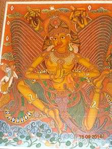
The city's Sree Vallabha Temple (ശ്രീവല്ലഭമഹാക്ഷേത്രം) is one of the famous Vishnu temples of India. It is one of the 108 "Vaishnava Divya Desams".
Another old and significant temple in Tiruvalla is the Mahadeva-Hanuman temple at Kaviyoor, which also has the "Thrikkakkudi" cave temple nearby.
The Sree Chakkulathukavu Devi temple is located west of Thiruvalla Taluk. The Mar Thoma Church, the Believers Church, the St. Thomas Evangelical Church, the Indian Pentecostal Church of God (IPC) and the Sharon Fellowship Church have their headquarters in and around Tiruvalla. The headquarters of the Niranam diocese of Malankara Orthodox Church, Marthoma Church and Malankara Catholic Tiruvalla Diocese, the Church of South India (CSI) are also in Tiruvalla. The Niranam, Parumala, Paliakkara, and Kallooppara churches are also common pilgrimage destinations.
Sports
The popular sports in Tiruvalla are football and cricket. The football history of Tiruvalla can be traced back to the legendary footballer from Tiruvalla, Thomas Varghese, called "Tiruvalla Pappan". He represented India in the London Olympics of 1948, and is described as one of the best defenders of 40's - 50's from India.[11] Today, Tiruvalla hosts many district and state level football and cricket tournaments. There is a stadium in Tiruvalla maintained by the Tiruvalla Municipal Council. This is the venue for most of the tournaments. It is also called "Prithi stadium".[12]
Indoor Cricket
The Kerala Cricket Association has set up a world-class indoor cricket stadium complex in Tiruvalla. The 8000 square foot facility is adjacent to the Tiruvalla municipal stadium. The facility also houses a library, multi-gym, board room, KCA district office, and a conference hall. Specially made natural grass wicket is the distinctive feature of the practising nets in the courtyard.[13]
Health care
Tiruvalla has appreciable health care facilities. There are several small and large hospitals situated in and around the city. The hospitals belong to the Allopathy or Ayurvedic schools of medicine. The following are some of the major hospitals in Tiruvalla :
- Aswathibhavan Chikitsa Nilayam
- Believers Church Medical College Hospital
- GK Hospital
- Government Taluk Hospital
- Mary Queens Allergy Speciality Hospital
- Pushpagiri Medical College Hospital
- Sudarshanam Netra Chikitsalayam, Thymala, Manjadi
- Thiruvalla Medical Mission Hospital
- Vasan Eye Care Super Speciality Eye Hospital
- Sree Dhanwanthari Madom Ayurvedic clinic
- Chaitanya Eye Hospital, Manjadi,Thiruvalla
- Mar Gregorios Hospital, Pàrumala,Thiruvalla
Notable people from the taluk
- Abraham Kovoor, hypnotherapist and rationalist
- Abu Abraham, cartoonist
- Madathilparampil Mammen Thomas, former Governor of Nagaland, Chairperson of the World Council of Churchers (WCC)
- Babu Thiruvalla, movie director and producer
- Baselios Marthoma Didymos I, former Catholicos of India and All the East (Malankara Orthodox Church)
- Blessy (Blessy Iype Thomas), movie director
- C. K. Ra, famous artist
- C.P. Mathen (1890–1960), banker and founder of the Quilon Bank, Member of Parliament from Mavelikkara to the first Lok Sabha (1952), Indian Ambassador to the Sudan (1957)
- Chippy, movie actress
- John Abraham, movie director
- K. G. George, movie director
- Kakkanadan, novelist and writer
- Kaveri, movie actress
- Kaviyoor Ponnamma, movie actress
- M. G. Soman, movie actor
- Aju Varghese, movie actor
- Mathew T. Thomas, Minister of Water Resources 2016-present , MLA 2006–present, and 1987-1991, Janata Dal, former transport minister of Kerala (2006–2009)
- Meera Jasmine (Jasmine Mary Joseph), movie actress
- Nayan Thara (Diana Kurian), movie actress
- Mathunny Mathews
- Most Rev Dr. Philipose Mar Chrysostom, Mar Thoma Valiya Metropolitan
- Ammantharayil George Sharon Fellowship Church
Places in Tiruvalla
See also
References
- ↑ http://www.censusindia.gov.in/pca/SearchDetails.aspx?Id=676380
- ↑ "Efforts on to give facelift to Thiruvalla". The Hindu. 2015-12-17. ISSN 0971-751X. Retrieved 2016-03-20.
- ↑ "Census of India 2001: Data from the 2001 Census, including cities, villages and towns (Provisional)". Census Commission of India. Archived from the original on 2004-06-16. Retrieved 2008-11-01.
- 1 2 3 4 Shree Vallabha Mahakshethra Charitham, P. Unnikrishnan Nair
- 1 2 "KISSAN - Kerala". www.kissankerala.net. Retrieved 2016-03-20.
- 1 2 3 "Climate: Thiruvalla - Climate graph, Temperature graph, Climate table - Climate-Data.org". en.climate-data.org. Retrieved 2016-03-20.
- ↑ "Indus Civilisation and Tamil Language - Part 03", page 34
- ↑ Menon, A. Sreedhara (2007-01-01). A Survey Of Kerala History. DC Books. ISBN 9788126415786.
- ↑ "ORDER NO. 9 - TABLE A & B – ASSEMBLY AND PARLIAMENTARY CONSTITUENCIES AND THEIR EXTENT" (PDF). Kerala. DELIMITATION COMMISSION OF INDIA. Retrieved 2005-05-31.
- ↑ Census of India - Thiruvalla City population Religion data
- ↑ "This Tiruvalla Defender Stood Like a Wall in London Olympics". The New Indian Express. Retrieved 2016-03-20.
- ↑ "Untitled Document". cricketarchive.com. Retrieved 2016-03-20.
- ↑ "World-class indoor cricket facility for Thiruvalla". The Hindu. 2015-09-09. ISSN 0971-751X. Retrieved 2016-03-20.
External links
| Wikimedia Commons has media related to Thiruvalla. |
 |
Edathua | Changanassery | Mallapally | |
| Mannar, | |
Pullad | ||
| ||||
| | ||||
| Mavelikkara | Chengannur | Kozhencherry |