West End (Richmond, Virginia)
| The West End | |
|---|---|
| Neighborhood | |
 The West End Location within the state of Virginia | |
| Coordinates: 37°37′16″N 77°33′30″W / 37.62111°N 77.55833°WCoordinates: 37°37′16″N 77°33′30″W / 37.62111°N 77.55833°W | |
| Country | United States |
| State | Virginia |
| Independent city | Richmond |
| Time zone | Eastern (EST) (UTC-5) |
| • Summer (DST) | EDT (UTC-4) |
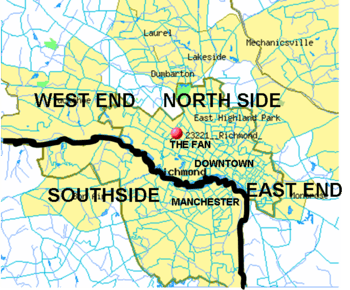
The West End is a part of Richmond, Virginia. Comparable to Upstate New York, the West End is a relative term. It may include only the western part of the city of Richmond or extend as far as western Henrico County. As there is no one municipal organization that represents this specific region, the boundaries are loosely defined as being north of the James River, west of I-195, and south of Broad Street. Historically, the Richmond neighborhoods of the Fan and the Museum District were a part of the West End. A primary conduit through the West End is Interstate 64.
Geographic description
This section is arranged by exits off Interstate 64. In previous decades, the term "The West End" generally referred to the western area of the city itself. However, in recent years, the urbanized area has expanded residentially and commercially into Henrico County, and new developments in the western portion of the city and county in combination are now also considered to be part of "The West End."
A common tool of differentiation used locally is to refer to the westernmost part (generally beginning at the Richmond-Henrico Line going west to Short Pump) as "The Far West End," and to refer to the section closer to and within the city limits as "The Near West End" or "Westhampton."
In addition to Richmond, Virginia addresses, the West End includes the census-designated places of part of Glen Allen, and all of Short Pump, Tuckahoe, and Wyndham.
Staples Mill Road, Willow Lawn, and Westhampton
- Exit 185 - US-33/Staples Mill Rd
- Anthem/Wellpoint
Broad and Glenside
- 183C - U.S. 250 West - Broad St./Glenside Dr. North
- 183B - U.S. 250 East - Broad St
- 183A - Glenside Dr. South
- Genworth and Philip Morris USA
- Chinatown at Horsepen Road
Parham Road
- 181B - Parham Rd. North
- 181A - Parham Rd. South
Gaskins Road and Innsbrook
- Exit 180B - Gaskins Rd. North
- Exit 180A - Gaskins Rd. South
- Former Circuit City corporate headquarters
Short Pump
- Exit 178B - U.S. 250 East - Richmond
- Exit 178A - U.S. 250 West - Short Pump
- MeadWestvaco
I-295 and Nuckols Road
Parks and recreation
- Cheswick Park
- Deep Run Park
- Echo Lake
- Short Pump
- Springfield
Education
Elementary schools
Dumbarton Elementary Schools
- Richmond Public Schools
- Henrico County Public Schools
- Crestview Elementary School
- Echo Lake Elementary School
- Gayton Elementary School
- Jackson Davis Elementary School
- Johnson Elementary School
- Longan Elementary School
- Maybeury Elementary School
- Nuckols Farm Elementary School
- Pemberton Elementary School
- Pinchbeck Elementary School
- Rivers Edge Elementary School
- Ridge Elementary School
- Ruby F. Carver Elementary School
- Shady Grove Elementary School
- Short Pump Elementary School
- Skipwith Elementary School
- Springfield Park Elementary School
- Tuckahoe Elementary School
- Twin Hickory Elementary School
- Colonial Trail Elementary School
Middle schools
High schools
Private and parochial schools
- Benedictine High School
- Collegiate School
- Rudlin Torah Academy (Richmond, Virginia)
- Shaarei Torah of Richmond
- St. Catherine's School (girls)
- St. Christopher's School (boys)
- Saint Gertrude High School
- The Steward School
- The Benjamin and Lillian Rochkind Yeshiva of Virginia
- The Faison School for Autism
- Dominion School for Autism
Colleges and universities
- University of Richmond
- Strayer University West End Campus
Culture
Museums
- Virginia Museum of Fine Arts
- Virginia Historical Society
- Virginia House, a historic house museum operated by the Virginia Historical Society
- Wilton House Museum
Theater and entertainment
- Agecroft Hall
- The Cultural Arts Center at Glen Allen
- Innsbrook After Hours, an annual summer series concert
Commerce
The principal non-interstate east-west commercial corridors are located along Broad Street (U.S. Highway 250) and Patterson Avenue (State Route 6) each of which extends from the Richmond City Limits westerly through Henrico County into Goochland County. There are many restaurants, businesses and shopping centers, mostly located along or near the three major thoroughfares (Broad Street road and Patterson Avenue runs east-west, Parham runs north-south ). Several major clusters include:
- Willow Lawn Shopping Center just west of city limits at Broad Street and Staples Mill Road. One of the first large shopping centers when first opened in the late 1950s, Willow Lawn has been substantially reconfigured and rebuilt to a semi-shopping mall configuration, and includes major stores, small shops, and a food court.
- "The Village" shopping center at Three Chopt and Patterson (near the University of Richmond). It is currently home to CVS/pharmacy, Martin's, Moe's Southwest Grill, Starbucks, and Subway among other venues.
- Westhampton historic commercial district extending from the Patterson and Libbie intersection to the Libbie and Grove shopping district, where one can find cafés and upscale clothing boutiques.
- Regency Square Mall and Westbury Shopping Center -- This area includes many locally-owned and chain restaurants, including Westbury Pharmacy, former workplace of Elliott Yamin. This area is adjacent to Douglas S. Freeman High School.
- Short Pump Town Center An "open air shopping mall" (classified as a "lifestyle center") opened in 2003 on Broad Street, approximately 1 mile (1.6 km) west of I-64 Exit 178A/B. Anchor stores are Nordstrom, Dillard's, Macy's and Dick's Sporting Goods.
Industry
- Innsbrook Business Park, a 600-acre (2.4 km2) business park that opened in 1982 and houses several Fortune 500 companies.
- West Creek Business Park, originally developed for a Motorola plant that never materialized. . West Creek is now home to the CarMax Home Office and Capital One. It is also a popular place for weekend bikers.
Other
- The Country Club of Virginia. Churches, schools, and houses surround this development at the corner of Three Chopt and River Road. Long ago, this area was the town of Rio Vista, Virginia.
- Grove Avenue Baptist Church, at the highest point in the Richmond-Metropolitan area
- The Rotary Club of West Richmond. A service organization which meets in Richmond's West End.