The Round House, Stanton Drew
| Round House | |
|---|---|
| Native name Toll House | |
 | |
| Location | Stanton Drew, Somerset, England |
| Coordinates | 51°22′13″N 2°34′52″W / 51.37028°N 2.58111°WCoordinates: 51°22′13″N 2°34′52″W / 51.37028°N 2.58111°W |
| Built | 18th century |
Listed Building – Grade II | |
| Designated | 4 December 1986[1] |
| Reference no. | 1136251 |
 Location of Round House in Somerset | |
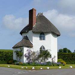
The Round House (also known as The Toll House) at Stanton Drew in the English county of Somerset was built in the 18th century. It has been designated as a Grade II listed building.[1]
The two-storey thatched building is hexagonal in plan.[1] It is on the road between Chew Magna and Pensford and close to the bridge over the River Chew.
It was built around 1793 by the West Harptree Turnpike Trust and served as a toll house when turnpikes were in use.[2][3] A pouch hung on a hook over the door was used by coach drivers to pay the toll.[4]
In the 1850s it was home to the Burridge family who acted as the toll collectors until the Turnpike Trust was abolished in 1876.[3] From 1896 to the 1940s was lived in by Frederick Rich.[5] It was still occupied in 2012.[6]
References
| Wikimedia Commons has media related to Stanton Drew Round House. |
- 1 2 3 Historic England. "The Round House (1136251)". National Heritage List for England. Retrieved 4 April 2015.
- ↑ Mason, Edmund J. & Mason, Doreen (1982). Avon Villages. Robert Hale Ltd. ISBN 0-7091-9585-0.
- 1 2 Durham, Ian (1991). Chew Magna and the Chew Valley. Bristol: Redcliffe Press. pp. 114–115. ISBN 187297161X.
- ↑ "The house by the side of the road". The past that whispers. Retrieved 11 December 2013.
- ↑ "Stanton Drew". Bitton Families. Retrieved 11 December 2013.
- ↑ "Ten strange UK houses". Britain Explorer. Retrieved 11 December 2013.