The Dalles Dam
| The Dalles Dam | |
|---|---|
 From the Washington side | |
| Official name | The Dalles Lock and Dam |
| Location | Klickitat County, Washington / Wasco County, Oregon, USA |
| Coordinates | 45°36′44″N 121°08′04″W / 45.61222°N 121.13444°WCoordinates: 45°36′44″N 121°08′04″W / 45.61222°N 121.13444°W |
| Construction began | 1952 |
| Opening date | 1957 |
| Operator(s) |
U.S. Army Corps of Engineers (Operator) Bonneville Power Administration (Marketer) |
| Dam and spillways | |
| Type of dam | Concrete gravity, run-of-the-river |
| Height | 200 feet (61 m) |
| Length | 8,835 feet (2,693 m) |
| Width (base) | 239 feet (73 m) (Spillway) |
| Spillway type | Service, gate-controlled |
| Spillway capacity | 2,290,000 cu ft/s (65,000 m3/s) |
| Reservoir | |
| Creates | Lake Celilo |
| Total capacity | 330,000 acre·ft (0.41 km3) |
| Power station | |
| Turbines | 22 |
| Installed capacity |
1,878.3 MW Max.: 2,160 MW |
| Annual generation | 6,180 GWh[1] |
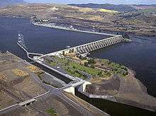
The Dalles Dam is a concrete-gravity run-of-the-river dam spanning the Columbia River, two miles (3 km) east of the city of The Dalles, Oregon, United States.[2] It joins Wasco County, Oregon with Klickitat County, Washington, 192 miles (309 km) upriver from the mouth of the Columbia near Astoria, Oregon. The closest towns on the Washington side are Dallesport and Wishram.
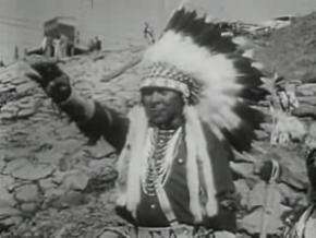
The Army Corps of Engineers began work on the dam in 1952 and completed it five years later. Slackwater created by the dam submerged Celilo Falls, the economic and cultural hub of Native Americans in the region and the oldest continuously inhabited settlement in North America.[3] On March 10, 1957, hundreds of observers looked on as the rising waters rapidly silenced the falls, submerged fishing platforms, and consumed the village of Celilo.
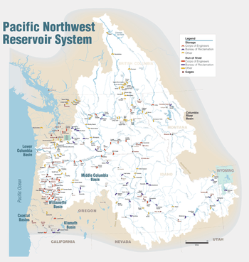
The reservoir behind the dam is named Lake Celilo and runs 24 miles (39 km) up the river channel, to the foot of John Day Dam. The dam is operated by the U.S. Army Corps of Engineers (USACE), and the power is marketed by the Bonneville Power Administration (BPA). It is part of an extensive system of dams on the Columbia and Snake Rivers.
The Dalles Dam Visitor Center, in Seufert Park on the Oregon shore, was built in 1981. A tour train was closed in autumn 2001, partly due to post-September 11 security oncerns, and partly due to deteriorating track conditions and a small derailment. The Columbia Hills State Park is nearby.
Specifications
- Altitude: 79 feet (24 m) above sea level
- Height: 200 feet (61 m)[4] (Lake Celilo normal pool elevation 158 feet (48 m))[5]
- Length: 8,835 feet (2,693 m)[4]
- Navigation lock:
- Powerhouse:
- Spillway:
Gallery
 Vice-President Richard Nixon speaking at The Dalles Dam dedication in 1959.
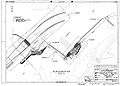 The Dalles Dam site plan.
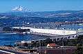 Looking west, fish ladder in the foreground, power generation center. Mount Hood rises in the background.
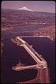 The Dalles Dam in
June 1973.
See also
- List of dams in the Columbia River watershed
- List of largest hydroelectric power stations in the United States
References
- ↑ http://carma.org/plant/detail/45210
- ↑ "The Columbia River System Inside Story" (PDF). BPA.gov. pp. 14–15. Retrieved 17 July 2010.
- ↑ Dietrich, William (1995). Northwest Passage: The Great Columbia River. Seattle, WA: University of Washington Press. p. 52.
- 1 2 "The Dalles Lock and Dam". National Performance of Dams Program. Retrieved 1 March 2016.
- 1 2 3 4 5 6 7 8 9 10 "The Dalles Lock and Dam Fact Sheet" (PDF). United States Army Corps of Engineers. 2013. Retrieved 1 March 2016.
External links
| Wikimedia Commons has media related to The Dalles Dam. |
- The Dalles Lock & Dam - The U.S. Army Corps of Engineers
- "The Dalles Dam to Submerge Famous Indian Fishing Spot." Popular Mechanics, April 1956, pp. 138–140.
| lat_d = 45.612343 | long_d = -121.134514 | coordinates_display = inline,title | coordinates_type = type:landmark | type:landmark_region:US-OR|display=t
| Crossings of the Columbia River | ||||
|---|---|---|---|---|
| ||||