The Banks
| The Banks | |
|---|---|
|
| |
| General information | |
| Status | Under construction |
| Type | Office, Commercial, Residential |
| Location | Cincinnati, Ohio, United States |
| Construction started | April 2, 2008 |
| Estimated completion | 2018 |
| Design and construction | |
| Developer | Carter,[1] The Dawson Company[2] |
The Banks is the name given to the current mixed-use project being developed on the land between Paul Brown Stadium and Great American Ball Park along the Ohio River in Cincinnati, Ohio.[3]
History
| The Banks on Opening Day 2012 | |
|---|---|
|
Courtesy of Mark Bowen |
The construction for a new riverfront area between the two stadiums is the result of a public participation planning process begun in October 1996. Hamilton County and the City of Cincinnati engaged Urban Design Associates to prepare a plan to give direction in two public policy areas:
- To site the two new stadiums for the Cincinnati Reds and the Cincinnati Bengals
- To develop an overall urban design framework for the development of the central riverfront which would capitalize on the major public investment in the stadiums and structured parking.
A Riverfront Steering Committee made up of City and County elected officials and staff was formed as a joint policy board for the Central Riverfront Plan. Focus groups, interviews, and public meetings were held throughout the planning process.
A Concept Plan was published in April 1997 which identified three possible scenarios for the siting of the stadiums and the development of the riverfront. The preparation of a final Master Plan was delayed due to a November 1998 public referendum on the siting of the Reds Stadium. Once the decision on the Reds Stadium was made by the voters in favor of a riverfront site, Hamilton County and the City of Cincinnati appointed sixteen prominent citizens to the Riverfront Advisors Commission who were charged to "recommend mixed usage for the Riverfront that guarantees public investment will create sustainable development on the site most valued by our community". The result of that effort was The Banks, a September 1999 report from the Advisors which contained recommendations on land use, parking, finance, phasing, and developer selection for the Central Riverfront. The final Master Plan includes The Banks recommendations from the advisors.[4]
Carter and The Dawson Co. were selected by the city of Cincinnati and Hamilton County as master developers for the 18-acre mixed-use project. Carter has also served as program manager for the construction of the city and county-funded parking garage and infrastructure components of The Banks project, including accommodation of parking for the Cincinnati Reds stadium. Bob Castellini, CEO of the Cincinnati Reds, was a chair of Joint Banks Steering Committee.
On November 1, 2007, Cincinnati City Council and Hamilton County approved of the project. Groundbreaking took place on April 2, 2008. The first phase, which opened in the summer of 2011, included Current at The Banks, a building containing 300 apartment units atop 96,000 square feet of street-level retail space. Currently, the apartments are fully leased and the retail space is approximately 92 percent occupied. Many of the retail tenants include bars, restaurants and musical venues such as Yard House, Tin Roof, Mahogany’s, Toby Keith’s I Love This Bar & Grill and Ruth’s Chris Steakhouse.[5]
The second phase of The Banks is slated to break ground in the summer of 2013. Phase II will include an additional 300 apartment units, more than 60,000 square feet of street level retail and more than 400 parking spaces along Vine Street in between Second Street and Freedom Way. It will be located near Paul Brown Stadium, home of the Cincinnati Bengals.
Plans also call for the development of 180 Walnut @ The Banks, a 233,496-square-foot, Class A office building.
According to a recent study of Phase I by The University of Cincinnati Economic Center, it is estimated that The Banks will have an ongoing economic impact of $91.6 million, as well as generating $556 million in construction-based impact. Upon completion, The Banks will be the region’s largest mixed-use development and will house more than 3,000 residents. The city of Cincinnati, the county and a joint venture between Carter and The Dawson Company formed The Banks Public Private Partnership to secure funding and develop the project. Through a successful public-private partnership, The Banks is one of the nation’s preeminent urban "Live, Work, Play" destinations.
Awards
– 2012 NAIOP Impact Award for The Banks (Cincinnati chapter)
– 2013 National Planning Excellence Award for Implementation from American Planning Association (APA)
Smale Riverfront Park
Cincinnati Riverfront Park is planned to span over 40 acres (160,000 m2) of land along the Ohio River between Broadway and Central Avenue in Cincinnati, Ohio.
Design
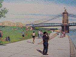
The park will connect Bicentennial Commons and Sawyer Point to form an almost 3-mile (5 km) corridor of public park along the river.
The park will include:
- Playgrounds
- Boat docks
- A Great Lawn
- Green spaces for festivals and community events
- A carousel
- Gardens
- Bike trails
- Walkways
- Tree groves
- A river's edge promenade with over-sized "porch" swings
- Water features (jets, cascades, pools and waterfalls)
- Grand stairs
Also considered for the park is a historical marker indicating the position of home plate of the former Cinergy Field (Riverfront Stadium). The area to be occupied by the Banks and the Riverfront Park is the former site of this storied facility, razed in 2002 after the completion of Great American Ballpark to the east.
As of 2013, Phase I is completed, including the Schmidlapp Stage and Event Lawn, the Walnut Street Steps and interactive fountain, the Main Street interactive fountain, the Black Brigade Monument, tree groves, a labyrinth, Cincinnati Bike and Visitor's Center, and the Moerlein Lager House. This is only a small portion of the other 45 acres of park space.[6]
Funding
- Congress has appropriated $3 million for design and planning. The federal government will contribute up to $50 million in additional funding.
- $3.5 million has been given by Cincinnati and Ohio for planning and design.
- Cincinnati has applied for $8 million federal funds and $2 million in state funds for the first phases of park construction.
- The initial $1 million has been provided by private funds.
- Total cost for the park will be $66 million.
- Annual costs for operation will be $1.2 million offset by parks, restaurants, retail, events, concessions, modest tax and private support.
- $20 million gift from John Smale in memory of his wife Phyllis
Transportation
The master plan for The Banks project includes a light rail transportation system. The Banks is the southern terminus of the first phase of the proposed Cincinnati Streetcar system, which if the second phase is completed, will link Uptown, Over-the-Rhine and Downtown to the riverfront and the new development occurring there.[7] The streetcar plan has recently been strongly supported by council, mayor Mark Mallory, and many organizations and businesses in the area.
Completed projects
 The Banks on Opening Day
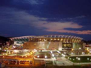

 Redesign of Fort Washington Way
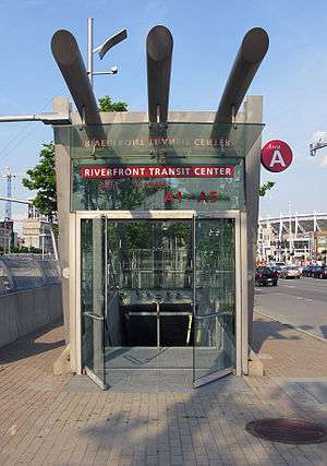
Construction gallery
 July 19, 2008
 September 20, 2008
 April 11, 2009
 June 6, 2009
 September 18, 2010
 November 6, 2011
 November 5, 2012
Notes
- ↑ http://www.carterusa.com
- ↑ http://www.thedawsoncompany.com
- ↑ The Enquirer – A change for the better at The Banks
- ↑ City of Cincinnati -Riverfront Development Master Plan
- ↑ The Enquirer – At long last – Banks OK'd
- ↑ http://www.cincinnatiparks.com/index.php/smale-riverfront-park
- ↑ Cincinnati Streetcar – Connect the Dots
External links
- The Cincinnati Central Riverfront Master Plan
- Banks Theme Page @ Cincinnati Enquirer
- Cincinnati Riverfront Park
- Smale Riverfront Park
- Parking at the Banks
Coordinates: 39°5′48″N 84°30′42″W / 39.09667°N 84.51167°W