Thargomindah
| Thargomindah Queensland | |||||||
|---|---|---|---|---|---|---|---|
 Outback roadhouse of Thargomindah | |||||||
 Thargomindah | |||||||
| Coordinates | 28°00′0″S 143°49′0″E / 28.00000°S 143.81667°ECoordinates: 28°00′0″S 143°49′0″E / 28.00000°S 143.81667°E | ||||||
| Population | 203 (2006 census)[1] | ||||||
| Postcode(s) | 4482 | ||||||
| Location |
| ||||||
| LGA(s) | Shire of Bulloo | ||||||
| State electorate(s) | Warrego | ||||||
| Federal Division(s) | Maranoa | ||||||
| |||||||
Thargomindah /ˈθɑːrɡoʊmɪndə/ is a town in South West Queensland, Australia on the Adventure Way, approximately 1,100 kilometres (680 mi) west of the state capital, Brisbane, 200 kilometres (120 mi) west of the town of Cunnamulla. Thargomindah is the administrative centre for the Shire of Bulloo and lies on the Bulloo River. At the 2006 census, Thargomindah had a population of 203.[1]
Facilities
An information centre is located in the historic mud brick building of the former hospital. The collection and arrangement of antique household items is a local attraction. The present hospital, located on Dowling Street, is run by dual Directors of Nursing, Alan Thompson and Chris Dodd. Sports grounds, caravan park and the powerhouse demonstration are available. The nearby river offers trees and water biotopes in the vicinity. Thargomindah has a public library open to the general public.
Heritage listings
Thargomindah has a number of heritage-listed sites, including:
- Bulloo River, Bulloo Downs: Dr Ludwig Becker's Grave[2]
- Nappa Merrie Station: Burke and Wills Dig Tree[3]
- Wilson Street, Noccundra: Noccundra Hotel[4]
Water
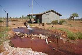
Thargomindah has a pressurised hot spring from a bore into the Great Artesian Basin and has produced hydroelectric power from the basin in the past. After 2 years of drilling, a good supply of water was found in 1893. The temperature was 86 °C (187 °F). In 1924, it was recorded that the bore had a daily output of 2,500 cubic metres (88,000 cu ft) and today of 1,300 cubic metres (46,000 cu ft) at 84 °C (183 °F). There is a plentiful water supply for the population and the arid area available for irrigation in front and backyards and public warm showers are provided.
History

The town was first settled in the 1860s at a crossing of the Bulloo River.[5] A post office was established in 1870 and a telegraph line connected the town to Cunnamulla in 1881. The 1890s saw the town prosper as the service and administrative centre of a pastoral district.[5]
Thargomindah was one of the first towns in Australia to produce hydroelectric power from 1898 until 1951, which then was taken over by diesel generators until 1988. The town was later connected to the national power grid via Cunnamulla. The old bore was a source of energy when electric street lights were lit and coupled to a turbine driven by the bore's natural water pressure. The generator was taken from a unit powered by a steam engine and purchased by the Bulloo Divisional Board becoming the first municipality owned power plant. The power station is still operating with a daily opening to the public.
Transport
Thargomindah Airport is located near the township. A railway extension to the town was planned for many years, however it never eventuated. The railway did reach Cunnamulla in 1898 and Quilpie in 1917.[5]
Climate
Thargomindah has a hot semi-arid climate.
| Climate data for Thargomindah | |||||||||||||
|---|---|---|---|---|---|---|---|---|---|---|---|---|---|
| Month | Jan | Feb | Mar | Apr | May | Jun | Jul | Aug | Sep | Oct | Nov | Dec | Year |
| Record high °C (°F) | 48.8 (119.8) |
46.0 (114.8) |
43.8 (110.8) |
38.9 (102) |
32.2 (90) |
30.4 (86.7) |
28.5 (83.3) |
36.3 (97.3) |
39.2 (102.6) |
41.2 (106.2) |
45.4 (113.7) |
45.0 (113) |
48.8 (119.8) |
| Average high °C (°F) | 38.5 (101.3) |
36.0 (96.8) |
33.5 (92.3) |
29.5 (85.1) |
23.8 (74.8) |
20.0 (68) |
20.1 (68.2) |
22.9 (73.2) |
27.8 (82) |
31.1 (88) |
33.8 (92.8) |
36.4 (97.5) |
29.5 (85.1) |
| Average low °C (°F) | 25.5 (77.9) |
24.0 (75.2) |
21.2 (70.2) |
16.6 (61.9) |
10.6 (51.1) |
7.5 (45.5) |
6.7 (44.1) |
8.3 (46.9) |
12.8 (55) |
16.6 (61.9) |
20.6 (69.1) |
23.0 (73.4) |
16.1 (61) |
| Record low °C (°F) | 17.2 (63) |
12.3 (54.1) |
9.4 (48.9) |
6.5 (43.7) |
1.0 (33.8) |
−0.8 (30.6) |
−0.9 (30.4) |
0.1 (32.2) |
4.7 (40.5) |
6.2 (43.2) |
9.7 (49.5) |
13.7 (56.7) |
−0.9 (30.4) |
| Average precipitation mm (inches) | 39.1 (1.539) |
47.9 (1.886) |
45.5 (1.791) |
17.5 (0.689) |
14.4 (0.567) |
16.7 (0.657) |
13.6 (0.535) |
8.0 (0.315) |
9.8 (0.386) |
14.1 (0.555) |
40.7 (1.602) |
30.3 (1.193) |
300.4 (11.827) |
| Average precipitation days | 3.6 | 4.5 | 4.4 | 1.4 | 2.8 | 3.9 | 3.5 | 2.0 | 2.6 | 3.4 | 5.5 | 4.4 | 42.0 |
| Source: [6] | |||||||||||||
References
- 1 2 Australian Bureau of Statistics (25 October 2007). "Thargomindah (L) (Urban Centre/Locality)". 2006 Census QuickStats. Retrieved 25 July 2009.
- ↑ "Dr Ludwig Becker's Grave (entry 601359)". Queensland Heritage Register. Queensland Heritage Council. Retrieved 7 July 2013.
- ↑ "Burke and Wills Dig Tree (entry 601073)". Queensland Heritage Register. Queensland Heritage Council. Retrieved 7 July 2013.
- ↑ "Noccundra Hotel (entry 600361)". Queensland Heritage Register. Queensland Heritage Council. Retrieved 7 July 2013.
- 1 2 3 Environmental Protection Agency (Queensland) (2002). Heritage Trails of the Queensland Outback. State of Queensland. pp. 114–115. ISBN 0-7345-1040-3.
- ↑ "Climate statistics for Thargomindah". Bureau of Meteorology. Retrieved 13 April 2013.
External links
| Wikimedia Commons has media related to Thargomindah, Queensland. |
-
 Thargomindah travel guide from Wikivoyage
 - Bulloo Shire
- Thargomindah on Action Graphics
- Thargomindah on WalkAbout
- Hydro Power Plant