Thames Gateway
Coordinates: 51°29′13″N 0°19′05″E / 51.487°N 0.318°E The Thames Gateway is an area of land stretching 70 kilometres (43 mi) east from inner east London on both sides of the River Thames and the Thames Estuary. The area, which includes much brownfield land was designated during the early years of the Blair ministry a national priority for urban regeneration, taking advantage of the development opportunities realised by the completion of the High Speed 1 (officially known as the Channel Tunnel Rail Link). First named by the UK government, which is unusual in the United Kingdom, uptake of and appreciation of the term varies, with many people preferring the traditional term, the Thames Estuary.[1]
It stretches from Westferry in Tower Hamlets to the Isle of Sheppey/Southend-on-Sea and extends across three ceremonial counties. Development that is supplemental to councils' own development plans is delivered through Local Authorities (Councils), special purpose development corporations and local enterprise partnerships, all of which are eligible for grants from government departments funded by HM Treasury. Additional government funds were supplied to the Regional Development Agencies who supported some projects in the Gateway.
Scope
The Thames Gateway has a population of over 3 million[2] and comprises generally Thameside belts of 16 local government districts:
| County | Districts | 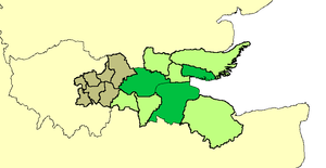 London boroughs (brown), non-metropolitan districts (green) and unitary authorities (dark green). |
|---|---|---|
| London | From the North East and South East London sub region, the London boroughs of Barking and Dagenham, Bexley, Havering, Lewisham, Greenwich, Newham and Tower Hamlets. These have non-planning powers similar to unitary authorities, however are influenced in planning by the Mayor of London and London Assembly. | |
| Essex | Planning authorities (influenced only by Essex County Council) (that is, non-metropolitan districts): Basildon, Castle Point and Rochford; and the (planning and) unitary authorities of Thurrock and Southend-on-Sea | |
| Kent | Planning authorities (influenced only by Kent County Council) (that is, non-metropolitan districts): Dartford, Gravesham and western parts of Swale; and the (planning and) unitary authority of Medway |
Profile
The immediate settlements next to the types of land indicated, not taking the authorities as a whole, contains about half of the population of those authorities: 1.6 million people and contained in the 2000 survey some of the most deprived wards in the country, characterised by lack of access to public transport, services, employment and affordable quality housing, in particular having many overspill estates from earlier slum clearance and London's urban planning – examples being from Thamesmead to Southend on Sea.[3]
Its boundary was drawn to capture the riverside strip that formerly hosted many land-occupying industries, serving London and the South East, whose decline has left a patchy legacy of dereliction and contaminated land. Striking precursor examples of development are those pioneered at Canary Wharf and on the Greenwich Peninsula, which the governments since 2000 have aimed to reflect across this area (having widespread comparable land use to those tracts of land).[3]
Its brownfield land, farmland and wild salt marshland has been seen by successive governments and planners as having potential to act as a catalyst for the regeneration and growth and for the social advancement of the area, helping to alleviate some of the growth pressures on London and the South East. Amid steep house price inflation and an economic boom in 2004 the government also expressed the firm belief that new private sector housing here and elsewhere would reduce that inflation.[4]
Parts of the area are of settled character and/or already densely populated with little scope for housing developments: Southend-on-Sea, for example, is the eighth most densely populated district in the country outside London and mass expansion is not desired owing to the river at the south, the need for leisure space and animal habitat (mostly in the buffer zones separating communities) and an economic desire and legal demand to preserve the existing character of housing estates.
Administration
The Department for Communities and Local Government is responsible for co-ordinating the project.
The Thames Gateway project aims to improve the economy of the region through the development of marshland, farmland and brownfield land, through major transport infrastructure provision and the renaissance of existing urban conurbations.
Comparisons may be drawn with developments east of Paris along the Marne valley, which applied to a significantly smaller volume of land.
Formerly the development was in part delivered by the three regional development agencies: the London Development Agency (LDA – part of the Greater London Authority), the East of England Development Agency (EEDA) and the South East England Development Agency (SEEDA), as well as the national regeneration agency, English Partnerships.
Former redevelopment zones
Formerly, the development was split into zones each with a different agency responsible for delivery. The zones were:
| Region | Zones | Former delivery agencies |
|---|---|---|
| London |
|
London Thames Gateway Development Corporation |
|
Greenwich Partnership and Bexley Partnership | |
| South East |
|
Kent Thameside Delivery Board, Medway Renaissance Partnership, Swale Forward |
| East | Thurrock Thames Gateway Development Corporation, Basildon Renaissance Partnership and Renaissance Southend |
Developments
Before 2003 most conspicuous development was situated west of Beckton. There have been substantial housing schemes at Chafford Hundred, Chatham and Greenhithe and there is a large shopping centre at Bluewater.
| Region | Project | Description | Status |
|---|---|---|---|
| London, East, South East | High Speed 1 | High speed rail line linking Stratford and Ebbsfleet stations in the Gateway area to central London and continental Europe. | Fully operational. |
| London | Thames Gateway Bridge | Road bridge between Beckton and Thamesmead near to the existing Woolwich Ferry. Designed to provide segregated bus, tram or DLR carriage. | Cancelled[5] |
| London | Stratford City | 73 hectares (0.73 square km) (180 acre) mixed use site of 200 shops, three large department stores, cafés, schools, hotels, parks and health centres. 11,000 residents and 30,000 workers. Part of the site was used for the London 2012 Olympics and will be converted by July 2013. | Completed. |
| London | East London Transit | The East London Transit is an intermodal transport scheme to connect housing developments to rail and tube. | Phase I opened Feb 2010. |
| London | White Hart Triangle | Mainly derelict land close to Plumstead railway station being developed with the aim of creating 2000 new jobs, with funding from the London Development Agency and European Union. | Currently Under Construction |
| East | London Gateway | The development is a world class port, and a logistics and business park. The port will be developed at Shell Haven, a 607 hectare (6 km2) (1,500 acre) site in Thurrock.[3] The two schemes are expected to create up to 16,500 new jobs.[6] | Port due to open 2011, business park 2008 |
| East | Southend-on-Sea | The council is using money provided through the scheme to redevelop the town centre and seafront and create a "transport corridor" along the A13. | |
| East | Basildon District | £2 billion major developments planned. These include the regeneration of Basildon, Wickford, Pitsea and Laindon town centres; a new sporting village, a health and education research centre, investment in the Basildon Enterprise Corridor business area, a wetland nature reserves in the Thames Marshes and investment in housing estates such as Craylands, Five Links and Felmores. | |
| South East | Ebbsfleet Valley | Ebbsfleet Valley is planned in the area around Ebbsfleet International station. It consists of over 790,000 square metre (8.5 million sq ft) of mixed-use development, including housing, retail, residential, hotel and leisure sites. According to a May 2007 press release from Land Securities, an "iconic landmark for Kent" will be planned here. A 50-metre high sculpture is planned to landmark Ebbsfleet and Ebbsfleet Valley, estimated to cost £2 million. | |
| South East | Swanscombe Peninsula | Previously the location of the Swanscombe Cement Works, this 130 hectare (1.3 square km) (320 acre) site, partly in both Dartford and Gravesham, is planned to have 2,700 homes and 500,000 sq ft (50,000 m2) of office space. | |
| South East | The Bridge | Lying close to the Queen Elizabeth II Bridge on and around the site of the former Joyce Green Hospital, this 107 hectare (1 km²) (264 acre) development will have 1.5 million square feet (140,000 m²) of business space and 1500 residences. | |
| South East | Dartford Northern Gateway | In early 2006 SEEDA (The South East England Development Agency) purchased a 2.6 hectare site on the edge of Dartford which had been used by Unwins, an off-license chain, which went into administration in 2005. They also purchased the neighbouring Matrix Business Centre to protect its future. They intend to develop the site with a mixture of retail and other businesses and housing. It is also the home to The Orchestra of the Thames Gateway, an organisation that has given more than 230 performances in the Gateway area up until the end of 2009. | |
| South East | Stone Castle | It is located to the north of Bluewater Shopping Centre and will be a mix of residences, a new publicly accessible linear park in St Clement's Valley and a high quality business park set back from St Clement's Way. Phase 1 is known as Waterstone Park, where about 200 of an eventual 650 residences have been built. | |
| South East | Northfleet Embankment | An industrial site of 74 hectares (0.74 km²) with 1.9 km of river frontage. Key sites have been acquired by SEEDA to prepare for the re-development of the area, which could potentially begin once the Northfleet Cement Works moves to the Medway Valley in 2008. | |
| South East | Chatham Town Centre & Waterfront | Projected to deliver 1500 new homes, plus a variety of other projects, including the Dickens World tourist attraction (opened May 2007); the Great Lines City Park; refurbishment and expansion of the Pentagon shopping centre with 1,4000 square metres of new stores and leisure facilities; a new 'cultural quarter' centred on Medway REACH, a new 2000 seat auditorium. Funding is being sought for a cable car system across the River Medway. | |
| South East | Gillingham Waterfront | 1000 new residences and 200 new jobs are projected to be created on this 32 hectare site by 2010. | |
| South East | Rochester Riverside | Key sites have been acquired by Medway Council and other areas are being acquired SEEDA to prepare for the re-development of the area, with 30 hectares being cleared and decontaminated. Proposed plans include 1700 new residences, with building work projected to start in 2008. 2.5 kilometres of new river wall are being constructed, with the site also being raised by 2 metres. | |
| South East | Strood Riverside | About 500 new homes, improved waterfront access and improved flood defences, with completion projected by 2012. | |
| South East | Temple Waterfront | A 21 hectare site with a possible 600 new homes and part of the waterfront designated for nature conservation. According to Medway Renaissance, the potential for a new railway station is being investigated. |
Environmental implications
The Thames Gateway project proposes removing parts of and building on the North Kent Marshes, which are recognised as an Environmentally Sensitive Area by the Department for Environment, Food and Rural Affairs and are largely covered by Sites of Special Scientific Interest. There are also fears of increased erosion. Opponents of development have argued that promoting the ecological significance of the area by increasing public accessibility to threatened marshes and wetlands, with improved transport corridors, will cause further erosion.
Proposals for a large international airport on Cliffe Marshes were dropped from the government's white paper on air transport in 2003 after they were rejected by local residents, the local council, as well as conservation charities such as the RSPB. The plan, which would have required the raising the ground level by 15 m.[7] was also rejected by the Confederation of British Industry as too expensive.[8]
On the question of airport capacity, the Government has established the independent Airports Commission, led by Sir Howard Davies. The Commission is examining the nature, scale and timing of any requirement for additional capacity to maintain the UK's global hub status. The Aviation Policy Framework of March 2013 was an important piece in the jigsaw, setting out the principles which the Commission will take into account in working up its recommendations as it reports later in 2013 and in 2015.[9] The options include outside possibility of a floating airport off the Isle of Sheppey.[10]
The north of Kent has historically been a marshland area and is under great pressure by developers. In addition to the great variety of wildlife found on and along the Thames, these marshes offer invaluable natural flood protection for London area, ever under threat of flooding. A public inquiry found in favour of a rail freight depot proposed by ProLogis at Howbury in Slade Green.[11] The proposal is to develop some of the Metropolitan Green Belt in the Crayford Marshes beside the present train depot. Roxhill has been seeking to modify the planned 149 acre "sustainable distribution park with modern multi modal connections" since at least 2015.[12]
The London Development Agency perceives some strategic merit in the proposals, although local councillors are not convinced that the depot would truly encourage train movements as an alternative to road haulage. This scepticism arises partly because the railways in the area are heavily used by scheduled passenger trains, to the extent that Crossrail trains seem unlikely to progress to Dartford unless new tracks were laid to boost local rail capacity. ProLogis’ appeal was upheld by a 2007 Public Inquiry on the basis that the proposal supports the Energy policy of the United Kingdom and generates new jobs. Counter-arguments included that eventual warehouse occupiers would not use the site in the manner suggested, and that continuous noise levels would exceed WHO Community Noise Guidelines at some homes in Moat Lane. It was also found that night-time noise levels risked generating complaints from residents at Moat Lane and Oak Road.[11]
Dave Wardle, of the Environment Agency, believes that "London and the Thames Estuary currently have one of the best tidal defence systems in the world". The Environment Agency assesses these systems will provide a high standard of protection well beyond 2030. However they also advise that future development in the Thames Gateway must go hand in hand with flood risk management, and take account of future plans for flood protection. The Agency insists it is important that effective flood risk management of the whole Estuary is not prejudiced by early decisions and development on the Gateway.[13]
The Government has addressed some of these environmental concerns by designating the Thames Gateway as the UK's "eco-region", first announced in the 2007 Thames Gateway Delivery Plan.[14] The objective of the "eco-region" is to protect and enhance the sustainability of the Thames Gateway, in terms of environmental quality, carbon reduction, and support for "green" economic development. This vision was elaborated in the 2008 Thames Gateway "eco-region prospectus",[15] and implementation efforts are being led by the Homes and Communities Agency with support across government and local stakeholders.
References
- ↑ Geoff Vigar (2002). The Politics of Mobility: Transport Planning, the Environment and Public Policy. Taylor & Francis. ISBN 0415259169.
- ↑ http://www.ons.gov.uk/ons/rel/census/2011-census/key-statistics-for-local-authorities-in-england-and-wales/rft-table-qs203ew.xls
- 1 2 3 "General Description". London Gateway. Archived from the original on 19 March 2008. Retrieved 2 March 2013.
- ↑ "Kate Barker's Review of Housing supply: Final Report published". HM Treasury. 17 March 2004. Retrieved 2 March 2013.
- ↑ "Mayor outlines ten-year plan for massive transport expansion". Mayor of London. Retrieved 10 November 2008.
- ↑ "The Business Centre". London Gateway. Archived from the original on 19 March 2008. Retrieved 2 March 2013.
- ↑ Aviation document 026038 of 2003. Department for Transport
- ↑ Andrew Clark (16 December 2002). "Thumbs down to Kent airport". The Guardian. Retrieved 2 March 2013.
- ↑ Aviation Policy Framework: Command Paper 8584 presented to Parliament (by the Department for Transport) March 2013. Retrieved 30 August 2013
- ↑ "New airport threat for north Kent". BBC News. 16 June 2004. Retrieved 2 March 2013.
- 1 2 Phillipson, Andrew. "Report to the Secretary of State for Communities and Local Government" (PDF). The Planning Inspectorate. Retrieved 8 September 2016.
- ↑ "Howbury Park, Bexley - Planning Application in Progress". Roxhill. Roxhill. Retrieved 8 September 2016.
- ↑ "More than Mudflats and Microflats – the Thames Gateway landscape". Audacity.org. Retrieved 2 March 2013.
- ↑ "The Thames Gateway Delivery Plan". Communities and Local Government. 29 November 2007. Archived from the original on 22 February 2010. Retrieved 2 March 2013.
- ↑ "The Thames Gateway Eco-Region: A Prospectus" (PDF). Communities and Local Government. November 2008. Retrieved 2 March 2013.
External links
- Clark, Andrew (16 December 2002). Thumbs down to Kent airport. The Guardian (UK national title)
- Thames Gateway London Partnership
- Wildlife Gateway – Providing a resource for information on development with wildlife in mind
- Thames Gateway South Essex Partnership
- Thames Gateway Kent Partnership
- Greengrid – Connecting green spaces in South Essex
- Thames Gateway Forum
- Medway Renaissance
- Invest Thames Gateway website