Thai–Lao Friendship Bridge
| Thai–Lao Friendship Bridge | |
|---|---|
.jpg) | |
| Carries | Motor vehicles, Trains |
| Crosses | Mekong River, Thai-Lao border |
| Locale |
Nong Khai, Nong Khai province Vientiane, Vientiane Province |
| Official name | Thai–Lao Friendship Bridge |
| Characteristics | |
| Total length | 1.17 km (3,800 ft) |
| Width | 3.5 and 1.5 m (11 ft 6 in and 4 ft 11 in) |
| History | |
| Opened | April 4, 1994 |
The First Thai–Lao Friendship Bridge (Thai: สะพานมิตรภาพ ไทย-ลาว แห่งที่ 1, pronounced [sàpʰaːn míttràpʰâːp tʰaj laːw hɛ̀ŋ tʰîː nɯ̀ŋ]; Lao: ຂົວມິດຕະພາບ ລາວ-ໄທ ແຫ່ງທຳອິດ, [kʰǔə mittapʰâːp láːw tʰaj hɛŋ tʰám ǐt]) is a bridge over the Mekong, connecting Nong Khai province and the city of Nong Khai in Thailand with Vientiane Prefecture in Laos; the city of Vientiane is approximately 20 km (12 mi) from the bridge. With a length of 1,170 meters (0.73 mi), the bridge has two 3.5 m (11 ft 6 in)-wide road lanes, two 1.5 m (4 ft 11 in)-wide footpaths and a single 1,000 mm (3 ft 3 3⁄8 in) gauge railway line in the middle, straddling the narrow central reservation.
- The rail gauge is 1,000 mm (3 ft 3 3⁄8 in)
- The loading gauge might be 3,000 mm (9 ft 10 in)
- The structure gauge (roughly equal to a road lane) might be about 4,000 mm (13 ft 1 in)
History
Opened on April 8, 1994, it was the first bridge across the lower Mekong, and the second on the full course of the Mekong.
The cost was about £19 million, funded by the Australian government as development aid for Laos.[1]
The bridge was designed and built by Australian companies as a demonstration of their ability to complete major infrastructural projects in Southeast Asia. The concept design of a balanced cantilever bridge was proposed by Bruce Ramsay of VSL with the final design carried out by Maunsell consulting engineers.
The official name of the bridge was changed by the addition of "First" after the Second Thai–Lao Friendship Bridge further south at Savannakhet opened in January 2007.
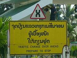
Road traffic
Traffic on the bridge drives on the left, as in Thailand, while traffic in Laos drives on the right. The changeover at the Lao end, just before the border post, is controlled by traffic lights.
A shuttle bus service operates across the bridge, between the Lao and Thai border posts.
Bicycles and tricycles etc can travel on either the road or the footpath.
Pedestrians can walk on the footpath.
The bridge is part of the AH12 Asian Highway Network.
Railway
A metre-gauge rail track from Nong Khai station runs along the centre of the bridge. Road traffic is stopped when a train is crossing.
On March 20, 2004, an agreement between the Thai and Lao governments was signed to extend the railway to Thanaleng Railway Station in Laos, about 3.5 km (2.2 mi) from the bridge. This will be the first railway link to Laos (but not the first railway, as a short portage line once existed). The Thai government agreed to finance the line through a combination of grant and loan.[2] Construction formally began on January 19, 2007.[3] Test trains began running on July 4, 2008.[2] Formal inauguration occurred on March 5, 2009.[4]
On February 22, 2006, approval of funding for the rail line from Thanaleng Railway Station to Vientiane, about 9 km, was announced by the French Development Agency.[5]
In November 2010 plans to extend the service from Thanaleng to Vientiane were abandoned.[6]
A posited high-speed rail link from China to Thailand through Laos would make the extension redundant. Although the crossing to Thanaleng has no public buses to connect with the trains that cross, only very expensive taxis, so it is effectively redundant already. It would also necessitate the construction of a new bridge near to the current First Friendship Bridge. In 2011, Prime Minister Yingluck Shinawatra's revised plan prioritises domestic rail expansion over the ambitious regional connectivity plan spearheaded by China.[7]
China is looking to build a high-speed line from Kunming all the way down to Singapore, passing through Laos, Thailand and Malaysia, a project that would increase China's GDP and those of the involved nations by US$375 billion, according to China Railway Corp.[8]
Since February 2010 the Eastern and Oriental Express crosses the Mekong via the bridge into Laos.[9]
See also
- List of crossings of the Mekong River
- Second Thai–Lao Friendship Bridge
- Third Thai–Lao Friendship Bridge
- Fourth Thai–Lao Friendship Bridge
- Transport in Laos
- Transport in Thailand
References
- ↑ http://www.ausaid.gov.au/publications/focus/feb09/focus_feb09_08.pdf
- 1 2 "Testing takes train into Laos". Railway Gazette International. 2008-07-07.
- ↑ "Laos link launched". Railway Gazette International. 2007-03-01.
- ↑ "Thai-Lao train service launched". Bangkok Post. 2009-05-03.
- ↑ Saeung, Sopaporn (February 23, 2006). "France okays Thai-Laos railway link", The Nation.
- ↑ "Laos scraps full rail link to Nong Khai", Bangkok Post, November 6, 2010Template:Retrieved link
- ↑ Jutarat Skulpichetrat (August 23, 2011). "Thailand revises high-speed rail plan, Laos link shelved". Reuters. Archived from the original on 2012-07-18. Retrieved July 18, 2012.
- ↑
- ↑ http://www.luxurytravelmagazine.com/news-articles/eastern-oriental-express-makes-its-first-journey-over-friendship-bridge-14412.php
External links
| Wikimedia Commons has media related to Thai–Lao Friendship Bridge. |
Coordinates: 17°52′42″N 102°42′56″E / 17.87833°N 102.71556°E