Tessy-sur-Vire
| Tessy-sur-Vire | |
|---|---|
|
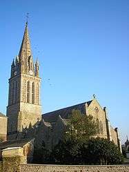
L'église Saint-Pierre | |
 Tessy-sur-Vire | |
|
Location within Normandy region  Tessy-sur-Vire | |
| Coordinates: 48°58′30″N 1°03′34″W / 48.975°N 1.0594°WCoordinates: 48°58′30″N 1°03′34″W / 48.975°N 1.0594°W | |
| Country | France |
| Region | Normandy |
| Department | Manche |
| Arrondissement | Saint-Lô |
| Canton | Condé-sur-Vire |
| Intercommunality | Saint-Lô Agglo |
| Government | |
| • Mayor (2008–2014) | Michel Richard |
| Area1 | 15.90 km2 (6.14 sq mi) |
| Population (2006)2 | 1,473 |
| • Density | 93/km2 (240/sq mi) |
| Time zone | CET (UTC+1) |
| • Summer (DST) | CEST (UTC+2) |
| INSEE/Postal code | 50592 / 50420 |
| Elevation |
34–210 m (112–689 ft) (avg. 50 m or 160 ft) |
|
1 French Land Register data, which excludes lakes, ponds, glaciers > 1 km² (0.386 sq mi or 247 acres) and river estuaries. 2 Population without double counting: residents of multiple communes (e.g., students and military personnel) only counted once. | |
Tessy-sur-Vire is a former commune in the Manche department in Normandy in north-western France. On 1 January 2016, it was merged into the new commune of Tessy-Bocage.[1]
Heraldry
.svg.png) |
The arms of Tessy-sur-Vire are blazoned : Gules, a 3-arched bridge argent masoned sable issuant from a base engrailed azure (waves). |
See also
References
- ↑ Arrêté préfectoral 28 September 2015 (French)
| Wikimedia Commons has media related to Tessy-sur-Vire. |
This article is issued from Wikipedia - version of the 4/6/2016. The text is available under the Creative Commons Attribution/Share Alike but additional terms may apply for the media files.