Tessenderlo
| Tessenderlo | |||
|---|---|---|---|
| Municipality | |||
|
Chemical plant and rail yard in Tessenderlo | |||
| |||
 Tessenderlo Location in Belgium | |||
|
Location of Tessenderlo in Limburg 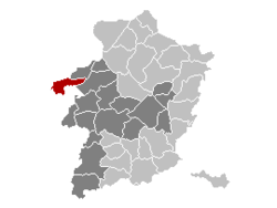 | |||
| Coordinates: 51°04′N 05°05′E / 51.067°N 5.083°ECoordinates: 51°04′N 05°05′E / 51.067°N 5.083°E | |||
| Country | Belgium | ||
| Community | Flemish Community | ||
| Region | Flemish Region | ||
| Province | Limburg | ||
| Arrondissement | Hasselt | ||
| Government | |||
| • Mayor | Fons Verwimp (sp.a) | ||
| • Governing party/ies | sp.a, OpenVLD, SPiL | ||
| Area | |||
| • Total | 51.35 km2 (19.83 sq mi) | ||
| Population (1 January 2016)[1] | |||
| • Total | 18,403 | ||
| • Density | 360/km2 (930/sq mi) | ||
| Postal codes | 3980 | ||
| Area codes | 013 | ||
| Website | www.tessenderlo.be | ||


Tessenderlo is a municipality located in the Belgian province of Limburg. It is where the three Belgian provinces of Limburg, Flemish Brabant and Antwerp meet at the front gate of the Averbode Abbey. The municipality Tessenderlo encompasses the villages of Tessenderlo proper, Schoot, Engsbergen, Hulst and Berg. On January 1, 2006, Tessenderlo had a total population of 16,811. The total area is 51.35 km² which gives a population density of 327 inhabitants per km².
It is along the Albert Canal and the European route E313, the highway between Antwerp and Liège, one of the reasons it was the place for the first Belgian "Industrial Zone of National Importance" in the 1960s.
Tessenderlo was the scene of an infamous industrial disaster during World War II, when a stock of 150 tonnes of ammonium nitrate at the chemical plant of Produits Chimiques de Tessenderloo (now Tessenderlo Chemie) - located near the centre of town - exploded on April 29, 1942, killing 189 people at the plant and in the town.
Tessenderlo is part of a small western zone of Limburg where the local dialect is not the Limburgian dialect, but Brabantic.
Notable people
- Kate Ryan, Belgian singer
- Chantal Calin, Belgian singer
- Tia Hellebaut, Olympic Champion 2008 Highjump
References
- ↑ Population per municipality as of 1 January 2016 (XLS; 397 KB)
External links
-
 Media related to Tessenderlo at Wikimedia Commons
 - Official website (Dutch)
 |
Laakdal (VAN) | |
Ham | |
| |
Beringen | |||
| ||||
| | ||||
| Scherpenheuvel-Zichem (VBR) | Diest (VBR) |