Teshio River
| Teshio River (Teshio-gawa) | |
| 天塩川 | |
| River | |
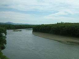 View from a train crossing a bridge on the Sōya Main Line (September 2008) | |
| Country | Japan |
|---|---|
| State | Hokkaidōse |
| Regions | Rumoi, Kamikawa |
| Districts | Shibetsu, Nayoro, Nakagawa, Teshio |
| Municipalities | Bifuka, Otoineppu, Nakagawa, Teshio, Horonobe |
| Source | Mount Teshio |
| - location | Shibetsu, Hokkaidō, Japan |
| - elevation | 1,558 m (5,112 ft) |
| - coordinates | JP 43°57′52″N 142°52′51″E / 43.96444°N 142.88083°E |
| Mouth | Sea of Japan |
| - location | Teshio and Horonobe, Hokkaidō, Japan |
| - elevation | 0 m (0 ft) |
| - coordinates | JP 44°52′44″N 141°44′18″E / 44.87889°N 141.73833°ECoordinates: JP 44°52′44″N 141°44′18″E / 44.87889°N 141.73833°E |
| Length | 256 km (159 mi) |
| Basin | 5,590 km2 (2,158 sq mi) |
| Discharge | |
| - average | 110 m3/s (3,885 cu ft/s) |
The Teshio River (天塩川 Teshio-gawa) is a river in Hokkaido, Japan. At 256 kilometres (159 mi), it is the fourth longest river in Japan.
The name of the river derives from an Ainu word meaning "fishing weir."
References
- "北海道の川ポータル~With River~/天塩川(てしおがわ)" (in Japanese). Sapporo: Ministry of Land, Infrastructure and Transport Hokkaido Regional Development Bureau. Retrieved 2009-01-21.
- 天塩町の概要 (in Japanese). Town of Teshio. Retrieved 2009-01-21.
External links
This article is issued from Wikipedia - version of the 6/23/2016. The text is available under the Creative Commons Attribution/Share Alike but additional terms may apply for the media files.