Terryville, Connecticut
| Terryville, Connecticut | |
|---|---|
| Census-designated place | |
|
Main Street (U.S. Route 6) in Terryville | |
 Terryville, Connecticut | |
| Coordinates: 41°40′41″N 73°0′39″W / 41.67806°N 73.01083°W | |
| Country |
|
| State |
|
| County | Litchfield |
| Area | |
| • Total | 7 km2 (2.8 sq mi) |
| • Water | 0.3 km2 (0.1 sq mi) |
| Population (2010) | |
| • Total | 5,387 |
| • Density | 740/km2 (1,900/sq mi) |
| Time zone | Eastern (UTC-5) |
| • Summer (DST) | Eastern (UTC-4) |
| ZIP code | 06786 |
| Area code(s) | 860 |

Terryville is a census-designated place (CDP) that can be found in Litchfield County, Connecticut, United States, and is the largest village within the town of Plymouth. In the 2010 census, Terryville was recorded as having a population of 5,387. The village is named for Eli Terry Jr., the son of the well-known clockmaker Eli Terry Sr. In addition to that, Terryville is also home to the Lock Museum of America. There is a water wheel located in downtown Terryville that is dedicated to the son of Eli Terry Sr.
Geography
According to the United States Census Bureau, the CDP has a total area of 7.3 km² (2.8 mi²). 7.2 km² (2.8 mi²) of it is land and 0.1 km² (0.04 mi²) of it (1.07%) is water.
Demographics
As of the census[1] of 2000, there were over 12,000 people, 2,199 households, and 1,460 families residing in the CDP. The population density was 747.1/km² (1,935.6/mi²). There were 2,312 housing units at an average density of 322.3/km² (834.9/mi²). The racial makeup of the CDP was 97.18% White, 0.86% African American, 0.15% Native American, 0.41% Asian, 0.30% from other races, and 1.10% from two or more races. Hispanic or Latino of any race were 1.18% of the population.
There were 2,199 households out of which 31.8% had children under the age of 18 living with them, 51.3% were married couples living together, 11.0% had a female householder with no husband present, and 33.6% were non-families. 28.9% of all households were made up of individuals and 11.7% had someone living alone who was 65 years of age or older. The average household size was 2.43 and the average family size was 3.01.
In the CDP the population was spread out with 25.4% under the age of 18, 6.9% from 18 to 24, 31.8% from 25 to 44, 21.0% from 45 to 64, and 14.9% who were 65 years of age or older. The median age was 37 years. For every 100 females there were 96.4 males. For every 100 females age 18 and over, there were 93.9 males.
The median income for a household in the CDP was $48,284, and the median income for a family was $58,713. Males had a median income of $41,132 versus $32,114 for females. The per capita income for the CDP was $22,202. About 3.6% of families and 4.8% of the population were below the poverty line, including 3.8% of those under age 18 and 5.8% of those age 65 or over.
Education

Terryville has four public schools: two Pre-K to Grade 5 elementary schools, one middle school, and one high school. Its elementary schools are the Harry S. Fisher Elementary School and the Plymouth Center School. Its one middle school is the Eli Terry Middle School. Terryville High School is the only public high school that Plymouth and Terryville residents may attend. A new high school building is located on North Harwinton Avenue in Terryville.
The Prospect Street School was used as the high school up until the 1970s. A new high school building was built on North Main Street and was used until January 2008. Prospect Street School then became an elementary school until its closing in January 2008.
Notable residents
- Actor Ted Knight was born in Terryville.
- Fashion designer Betsey Johnson lived in Terryville until c. 1960
- Major League Baseball player Pete Appleton was born in Terryville.
- Calista Flockhart's family resides in Terryville.
- HazelTree CEO Stephen Casner graduated Terryville High School in 1977
References
- ↑ "American FactFinder". United States Census Bureau. Retrieved 2008-01-31.
Municipalities and communities of Litchfield County, Connecticut, United States | ||
|---|---|---|
| Consolidated city | 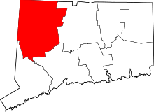 | |
| Towns | ||
| Non-consolidated city |
| |
| Boroughs | ||
| Other communities | ||
Coordinates: 41°40′41″N 73°00′39″W / 41.67806°N 73.01083°W