Territorial changes of Poland immediately after World War II
The territorial changes of Poland immediately after World War II were very extensive. In 1945, after the defeat of Nazi Germany, Poland's borders were redrawn in accordance with the decisions made first by the Allies at the Tehran Conference of 1943 where the Soviet Union demanded the recognition of the military outcome of the top secret Nazi-Soviet Pact of 1939 of which the West was unaware.[1]
The same Soviet stance was repeated by Josef Stalin again at the Yalta Conference with Roosevelt and Churchill in February 1945, but a lot more forcefully in the face of the looming German defeat.[2] The new borders were ratified at the Potsdam Conference of August 1945 exactly as proposed by Stalin who already controlled the whole of East-Central Europe.[2] Harry Truman remembered:
I remember at Potsdam, we got to discussing a matter in eastern Poland, and it was remarked by the Prime Minister of Great Britain that the Pope would not be happy over the arrangement of that Catholic end of Poland. And the Generalissimo, the Prime Minister of Russia leaned on the table, and he pulled his mustache like that, and looked over to Mr. Churchill and said: Mr. Churchill, Mr. Prime Minister, how many divisions did you say the Pope had?”[3]
Outcome
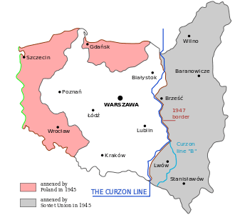
The prewar eastern Polish territories of Kresy, which the Red Army had overrun during the Nazi-Soviet invasion of Poland in 1939 (excluding the Białystok region) were permanently annexed by the USSR, and most of their Polish inhabitants expelled. As a result of the Potsdam agreement to which Poland's government-in-exile was not invited, Poland lost 179,000 km2 (45%) of prewar territories in the east, including over 12 million citizens of whom 4,3 million were ethnically the speakers of Polish. Today, these territories are part of sovereign Belarus, Ukraine, and Lithuania.[4]
In turn, postwar Poland was assigned considerably smaller territories to the west including the prewar Free City of Danzig and the former territory of Nazi Germany east of the Oder-Neisse line, consisting of the southern portion of East Prussia and most of Pomerania, Neumark (East Brandenburg), and German Silesia. The German population fled or was forcibly expelled before these Recovered Territories (official term) were repopulated with Poles expelled from the eastern regions and those from central Poland. The small area of Zaolzie, which had been annexed by Poland in late 1938, was returned to Czechoslovakia on Stalin's orders.
See also
| Territorial evolution of Poland in the 20th century |
|---|
|
Post World War II |
|
Areas
|
|
Demarcation lines
|
|
Adjacent countries |
- Territorial changes of Poland
- Geography of Poland
- Border Agreement between Poland and the USSR of 16 August 1945
- Curzon Line
- Oder–Neisse line
- Recovered Territories
- Territories of Poland annexed by the Soviet Union
References
- ↑ U.S. Department of State. "The Tehran Conference, 1943 - 1937–1945". Milestones - Office of the Historian. Retrieved 17 December 2015.
- 1 2 Simon Berthon, Joanna Potts (2007). Warlords: An Extraordinary Re-Creation of World War II. Da Capo Press. p. 285. ISBN 0306816504.
- ↑ “President Truman Speaks to the Scientists,” Bulletin of Atomic Scientists, 4/10, (October 1, 1948): p 292, https://books.google.co.il/books?id=0QsAAAAAMBAJ&printsec=frontcover&hl=iw&source=gbs_ge_summary_r&cad=0#v=onepage&q&f=false
- ↑ Sylwester Fertacz, "Krojenie mapy Polski: Bolesna granica" (Carving of Poland's map). Alfa. Retrieved from the Internet Archive on 14 November 2011.
- Arthur Bliss Lane. I saw Poland betrayed (Wikipedia). Indianapolis: The Bobbs-Merrill Company, 1948.