Tepic
| Tepic | ||
|---|---|---|
| City | ||
| Noble and Loyal city of Tepic | ||
| ||
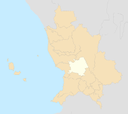 Location of Tepic municipality | ||
|
Tepic Location in Mexico | ||
| Coordinates: 21°30′30″N 104°53′35″W / 21.50833°N 104.89306°W | ||
| Country | Mexico | |
| State | Nayarit | |
| Municipality | Tepic | |
| Founded | November 18, 1531 | |
| Founded by | Nuño de Guzmán | |
| Government | ||
| • Mayor | Héctor González Curiel | |
| Elevation | 920 m (3,020 ft) | |
| Population (2010) | ||
| • City | 332 863 hab. | |
| • Metro | 489,511 | |
| • Metro density | 211,41/km2 (54,750/sq mi) | |
| • Demonym | Tepicense | |
| Time zone | MST (UTC−7) | |
| • Summer (DST) | MDT (UTC−6) | |
| Website |
www | |

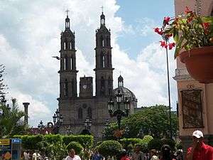
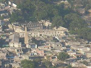
Tepic (![]() te'pik ) is the capital and largest city of the Mexican state of Nayarit.
te'pik ) is the capital and largest city of the Mexican state of Nayarit.
It is located in the central part of the state, at 21°30′30″N 104°53′35″W / 21.50833°N 104.89306°W. It stands at an altitude of 915 metres (3,002 ft) above sea level, on the banks of the Río Mololoa and the Río Tepic, approximately 225 kilometres (140 mi) north-west of Guadalajara, Jalisco. Nearby are the extinct Sangangüey volcano and its crater lake. Tepic is the primary urban center of this rich agricultural region; major crops include sugarcane, tobacco and citrus fruits.
The city was founded in 1531 as Villa del Espíritu Santo de la Mayor España.
Climate
Tepic has a humid subtropical climate (Köppen climate classification Cwa), with most rain falling in the wet season from June to October.
Demographics
Indigenous Population
Tepic has the second largest indigenous population in ths State of Nayarit, with 4.375. The most prominent among them are the Huichol (3.276), Cora 527 and Purépecha (101).
Religion
Catholicism is the most prominent religion in Tepic with 94,2% of the population.
Notable people
- Juan Escutia: Boy hero of the Battle of Chapultepec. Born in Tepic, between 1828 and 1832, on the morning of 13 September 1847, he fought to prevent invading U.S. forces from capturing Chapultepec Castle in Mexico City. After a brave defense, he is reported to have wrapped himself in the national flag and leaped to his death.
- Alexander Forbes, British consul to Mexico at Tepic, and author of the first English-language book on California
- Luis E. Miramontes: Chemist, co-inventor of the first contraceptive pill
- Amado Nervo: Poet and diplomat
- La Chilindrina (María Antonieta de las Nieves)
- Emilia Ortiz: Contemporary painter, caricaturist and poet, after whom the major downtown Centro de Arte Contemporaneo Emilia Ortiz has been named.
- Gustavo Ayón: NBA basketball player
- Francisco Guerrero (politician): Mayor of San Francisco, 1836-1842.
- Luis Ernesto Franco: Mexican actor
Sports
Nayarit had small stadiums built for football (soccer) and baseball. Both now demolished, they have a project to make new, modern, and bigger stadiums; the state has three sport private clubs. There are multiple football (soccer) fields and places to play "cascaritas" (pick-up games), indoor football (soccer) courts, a basketball center and gym (with wooden flooring), several volleyball courts, and a bowling alley. In addition to common sports, in the city's main park there is an olympic swimming pool and a squash field. In Tepic, tennis is a popular sport, but the most popular is soccer. The city also has a bullring, as do most Mexican cities. Tepic has several state teams, one or more for each sport. Both the soccer and the basketball teams are named "Coras". Futsal is also commonly played in the city.
| Climate data for Tepic (1951–2010) | |||||||||||||
|---|---|---|---|---|---|---|---|---|---|---|---|---|---|
| Month | Jan | Feb | Mar | Apr | May | Jun | Jul | Aug | Sep | Oct | Nov | Dec | Year |
| Record high °C (°F) | 31.5 (88.7) |
33.5 (92.3) |
34.5 (94.1) |
38.0 (100.4) |
35.0 (95) |
39.0 (102.2) |
37.5 (99.5) |
38.5 (101.3) |
35.2 (95.4) |
39.5 (103.1) |
36.0 (96.8) |
36.5 (97.7) |
39.5 (103.1) |
| Average high °C (°F) | 24.6 (76.3) |
25.6 (78.1) |
26.8 (80.2) |
28.7 (83.7) |
30.0 (86) |
29.2 (84.6) |
28.2 (82.8) |
28.2 (82.8) |
28.0 (82.4) |
27.8 (82) |
27.1 (80.8) |
25.3 (77.5) |
27.5 (81.5) |
| Daily mean °C (°F) | 16.3 (61.3) |
16.6 (61.9) |
17.6 (63.7) |
19.4 (66.9) |
21.4 (70.5) |
23.3 (73.9) |
23.4 (74.1) |
23.3 (73.9) |
23.3 (73.9) |
21.9 (71.4) |
19.3 (66.7) |
17.5 (63.5) |
20.3 (68.5) |
| Average low °C (°F) | 8.0 (46.4) |
7.6 (45.7) |
8.4 (47.1) |
10.1 (50.2) |
12.9 (55.2) |
17.4 (63.3) |
18.5 (65.3) |
18.5 (65.3) |
18.5 (65.3) |
16.0 (60.8) |
11.5 (52.7) |
9.7 (49.5) |
13.1 (55.6) |
| Record low °C (°F) | 1.5 (34.7) |
−0.4 (31.3) |
1.0 (33.8) |
0.0 (32) |
5.5 (41.9) |
8.0 (46.4) |
12.5 (54.5) |
10.0 (50) |
11.0 (51.8) |
6.0 (42.8) |
4.0 (39.2) |
1.5 (34.7) |
−0.4 (31.3) |
| Average precipitation mm (inches) | 29.5 (1.161) |
10.1 (0.398) |
7.4 (0.291) |
9.1 (0.358) |
8.9 (0.35) |
169.7 (6.681) |
378.6 (14.906) |
285.6 (11.244) |
221.5 (8.72) |
72.9 (2.87) |
17.5 (0.689) |
29.1 (1.146) |
1,239.9 (48.815) |
| Average precipitation days (≥ 0.1 mm) | 2.6 | 1.2 | 0.4 | 0.6 | 0.8 | 10.7 | 22.2 | 20.9 | 18.1 | 7.3 | 1.8 | 2.8 | 89.4 |
| Average relative humidity (%) | 68 | 66 | 64 | 62 | 65 | 73 | 78 | 79 | 79 | 76 | 71 | 69 | 71 |
| Mean monthly sunshine hours | 225 | 243 | 290 | 296 | 316 | 230 | 183 | 189 | 184 | 232 | 239 | 216 | 2,843 |
| Source #1: Servicio Meteorológico Nacional (humidity 1981–2000)[1][2][3] | |||||||||||||
| Source #2: Deutscher Wetterdienst (sun, 1961–1990)[4][lower-alpha 1] | |||||||||||||
Twin towns -Sister Cities
Notes
- ↑ Station ID for Tepic, NAY. is 76556 Use this station ID to locate the sunshine duration
References
- ↑ "Estado de Nayarit–Estacion: Tepic". NORMALES CLIMATOLÓGICAS 1951–2010 (in Spanish). Servicio Meteorológico Nacional. Retrieved 6 May 2015.
- ↑ "Extreme Temperatures and Precipitation for Tepic 1950–1991" (in Spanish). Servicio Meteorológico Nacional. Retrieved 6 May 2015.
- ↑ "NORMALES CLIMATOLÓGICAS 1981–2000" (PDF) (in Spanish). Servicio Meteorológico Nacional. Retrieved 6 May 2015.
- ↑ "Station 76556 Tepic, NAY.". Global station data 1961–1990—Sunshine Duration. Deutscher Wetterdienst. Retrieved 6 May 2015.
Sources
- Link to tables of population data from Census of 2005 INEGI: Instituto Nacional de Estadística, Geografía e Informática
- (Spanish) Nayarit Enciclopedia de los Municipios de México
External links
- (Spanish) Official website (Ayuntamiento de Tepic)
- Map