Temple Butte
| Temple Butte | |
|---|---|
|
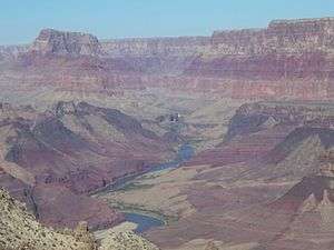
Temple Butte, and Lava Butte. Temple Butte is the mountain formation almost impossible to see that is located in the left background of this photo in front of a higher mountain formation with a black wall. Temple Butte's northeast slope is the crash site of Trans World Airlines Flight 2. Just behind Temple Butte is a higher mountain formation with a black wall, which is Chuar Butte. Chuar Butte's south wall is the crash site of United Airlines Flight 718. | |
| Highest point | |
| Elevation | 5,308 ft (1,618 m) |
| Prominence | Cape Solitude, 6144 ft, at north terminus Palisades of the Desert,[1] East Rim, Grand Canyon |
| Coordinates | 36°09′43″N 111°49′29″W / 36.16194°N 111.82472°WCoordinates: 36°09′43″N 111°49′29″W / 36.16194°N 111.82472°W |
| Geography | |
 Temple Butte, (confluence_of Little_Colorado_R. with_Colorado River) Palisades of the Desert,[2] East Rim, Grand Canyon | |
| Settlement | Grand Canyon Village, Arizona |
| Parent range | East Rim, 2-mi[3] south of Little Colorado River with Colorado |
| Geology | |
| Mountain type |
Toroweap Formation-(prominence), Coconino Sandstone, Hermit Formation & Supai Group |
Temple Butte, in the Grand Canyon, Arizona, USA is a prominence below the East Rim. The butte lies on the west bank of the south-flowing Colorado River. The outfall from the Little Colorado River, draining from the Painted Desert to the east and southeast, is about 2-mi upstream.
Temple Butte is 5,308 feet (1,618 m) in elevation. It is the historical site of some wreckage of the 1956 Grand Canyon mid-air collision. It was first thought that smoke from Temple Butte, was due to a lightning strike fire, but later was found to be the result of the mid-air collision.
Trails
The Tanner Trail from Desert View, Arizona down to the Colorado River, follows the west ridgeline of Tanner Canyon, and has numerous views looking due-north to Temple Butte. The trail ends at a viewpoint on the upper surfaces of a Redwall Limestone ridge. The Redwall Limestone is seen prominently below the East Rim, and is the cliff-forming shelf upon which the redbeds of the Supai Group accumulate.
Geology
The prominence of Temple Butte is composed of the Toroweap Formation, and below it, the tan or white, cross-bedded (fossil sand-dunes) of the Coconino Sandstone. The Coconino is a cliff-forming unit. The Hermit Formation and Supai Group "redbeds" below begin the base of the butte, as the slope-forming geological units.
The east strike (section) of the Butte Fault is on the west side of Temple Butte. The west section of the Butte Fault is the East Kaibab Monocline. The Butte Fault sections are north-south trending, and are part of the uplift of the Kaibab Plateau.
Access
Desert View is the closest paved route site to Temple Butte viewpoints. It is located on the East Rim, and is about 20-mi east of Grand Canyon Village, on the East Rim Road, (Arizona State Route 64). Desert View is also 32-mi west of U.S. 89, by way of Arizona 64.
Observation viewpoints
Temple Butte can be viewed from the south at East Rim, Grand Canyon viewpoints in the vicinity of Desert View, Arizona. Lipan Point, Desert View Point, and to the south Hollenback Point have views due-north into the Grand Canyon. About 5-mi north of Desert View Point by unimproved road, or hiking is Comanche Point, a distance of 5-mi south-southeast of Temple Butte.
An unimproved route, going north from Desert View, about 12 to 14 mi long ends at Cape Solitude; the point is adjacent the south canyon outfall of the Little Colorado River and canyon, with the Colorado River. Temple Butte is 2.5-mi west.[4]
References
- Arizona Road & Recreation Atlas, Benchmark Maps, 2nd Edition, c. 1998, 112 pages, pp. 28–29, 62-63.
- Arizona DeLorme Atlas & Gazetteer, 5th Edition, c. 2002, 76 pages, pp. 32, 24.
External links
| Wikimedia Commons has media related to Temple Butte. |
| Wikimedia Commons has media related to Toroweap Formation. |
| Wikimedia Commons has media related to Coconino Sandstone. |
| Wikimedia Commons has media related to Supai Group. |