Temagami
| Temagami | |
|---|---|
| Municipality (single-tier) | |
| Municipality of Temagami | |
|
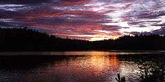
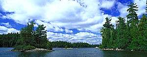
Temagami on the shores of Lake Temagami. | |
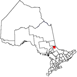 Location of Temagami in Ontario | |
| Coordinates: 47°04′N 79°47′W / 47.067°N 79.783°WCoordinates: 47°04′N 79°47′W / 47.067°N 79.783°W | |
| Country |
|
| Province |
|
| District | Nipissing |
| Settled | 1903 |
| Government | |
| • Mayor | Lorie Hunter |
| • Governing Body | Temagami Town Council |
| • MPs | Jay Aspin (CPC) |
| • MPPs | John Vanthof (ONDP) |
| Area[1] | |
| • Total | 1,906.42 km2 (736.07 sq mi) |
| Population (2011)[2] | |
| • Total | 840 |
| • Density | 0.4/km2 (1/sq mi) |
| Time zone | EST (UTC−5) |
| • Summer (DST) | EDT (UTC−4) |
| Postal Code | P0H |
| Area code(s) | 705 |
| Website | www.temagami.ca |

Temagami, formerly spelled as Timagami, is a municipality in northeastern Ontario, Canada, in Nipissing District with Lake Temagami at its heart.
The Temagami region is known as n'Daki Menan, the homeland of the area's Aboriginal community, most of whom are Anishnaabe (Ojibwe), living on Bear Island. The official name for this group is the Temagami First Nation. However, a larger group that includes these people, plus non-status residents and some non-residents is called the Teme-Augama Anishnabai.
Some of the main tourist attractions within the community include old-growth red and white pine, Lake Temagami, Caribou Mountain, fishing, showings of Grey Owl from the 1930s, and over 4,000 km of canoe routes.
It is also known as the staging point for cottage vacationing and wilderness canoeing trips on Lake Temagami, in Lady Evelyn-Smoothwater Provincial Park, and vast tracts of wilderness in the area. There are several outfitters here that cater to outdoor activity, including Smoothwater Outfitters and Ecolodge.
The community is home to the Finlayson Point Provincial Park, which itself offers access to Lake Temagami. An excellent view of the entire Temagami area is offered by the Temagami Fire Tower on Caribou Mountain, a renovated 100-foot (30 m)-tall fire lookout tower that visitors can climb for a small fee. The Temagami Fire Tower was last used in the 1970s to spot fires. The original fire tower built here was 45 feet (14 m) high and made of square timber.
The Municipality of Temagami also includes the communities of Lake Temagami, Marten River, and Temagami North.
History
The Anishnabai have been living in the area for at least 6,000 years after migrating from the east coast of North America. The land was divided into familial hunting and trapping territories.
Since the main east-west fur trade route bypassed Temagami to the south, settlement of this area by Europeans did not come until 1834. That year the Hudson's Bay Company built a store on Temagami Island, which later relocated to Bear Island. The town itself was founded by Dan O'Connor, who in 1903 formed a steamship company on the lake and established its first store on the future townsite. By 1906, he had built three hotels on Lake Temagami: Hotel Ronnoco, Temagami Inn, and Lady Evelyn Hotel.
Discoveries of gold, copper, nickel, and particularly silver in 1903, brought mining to nearby Cobalt and accelerated development of the region. Several mines opened in Temagami, including Big Dan Mine, Little Dan Mine, Barton Mine, Hermiston-McCauley Mine, Temagami-Lorrain Mine, Priest Mine, Beanland Mine, Sherman Mine, Kanichee Mine, Northland Pyrite Mine and Copperfields Mine, which once mined the richest copper ore in Canada.
The Forest Reserves Act of 1898 established the 15,000 km2 (5,800 sq mi) Temagami Forest Reserve. Because of this reserve, the region was home to the last old growth forests in Ontario. Logging of the vast pine stands only began in the 1920s. Now just a few patches of old growth remain, including the White Bear Forest (12.42 km²) and the world's largest stand of old-growth red and white pine forest - the Wakimika Triangle Forest (25 km²). This has led to confrontation in recent years between loggers and environmentalists when new logging access roads are built or major logging operations are proposed. Access to many old-growth areas is provided on local hiking trails and canoe routes.
The inspiration and wonder of the area were brought to millions around the world in 1907 when Grey Owl arrived in Temagami. He was employed by Keewaydin (camp) as a guide, and later by the Ontario Department of Lands and Forests as a ranger. His subsequent books and extensive lecturing in Britain and the United States brought tremendous attention to northeastern Ontario and wildlife conservation.
In 1968, Temagami was incorporated, first as an Improvement District, and 10 years later as a Township,[3] consisting of the geographic townships of Strathy and Strathcona, together with parts of Briggs, Chambers, Best, Cassels, and Yates townships.
In 1973, The Teme-Augama Anishnabai (TAA) exercised a land caution against development on the Crown land of 10,000 square kilometres, most of the Temagami area. The Attorney General of Ontario pursued legal action against the Band for this caution. The TAA lost this court case in 1984 and the Band proceeded with an Appeal to the Supreme Court. The Band lost this Appeal and eventually the Caution was lifted.
In 1988, the Ontario Minister of Natural Resources, Vince Kerrio approved the expansion of the Red Squirrel Road, directly through Anishnabe territory. This prompted a series of roadblocks by the TAA and by the Temagami Wilderness Society in 1988-1989. The Temagami First Nation's former chief Gary Potts was the leader of the TAA blockades. In 1991 the TAA and the Ontario government created the Wendaban Stewardship Authority to decide what to do with the four townships near the logging road.
On January 1, 1998, the Township of Temagami was greatly enlarged through the merger with 17 unincorporated townships and became the Municipality of Temagami with "town" status.
Transportation
Temagami Station and Yard


In the summer of 1905, the Temiskaming and Northern Ontario Railway (now the Ontario Northland Railway) was completed from North Bay to New Liskeard and allowed direct access to the area and the Great Clay Belt around Lake Temiscaming, opening up the region to settlement and development.[4]
Geography

The Temagami land is part of the Canadian Shield, one of the largest single exposure of Precambrian rocks in the world which were formed after the Earth's crust cooled. Temagami land has striking similarities to the Sudbury Structure, which is one of the richest mining camps in the world. The hills in the Temagami area are remnants of the oldest mountain ranges in North America that date back during the Precambrian era. These enormous mountains were taller than any that exist today. The uplifting was accomplished as enormous pressure caused the earth to buckle in a process called folding. Other processes, such as volcanic activity and geologic faulting in which the earth cracks open also contributed to the formation of these mountains. Over millions of years, these enormous mountains were gradually eroded to the land we know today in Temagami.
The rocks that form Temagami to this day are igneous, metamorphic and sedimentary rock. The Temagami area has good potential to host diamondiferous kimberlites and more diamond bearing kimberlites may continue to be discovered in the area. The Temagami area also contains some pillow lava about 2 billion years old, indicating that great submarine volcanoes existed during the early stages of the formation of the Earth's crust.
There are a number of northwest trending faults in the Temagami East claim block area and are associated with the Saint Lawrence Rift System and remains seismically active. The most recent felt earthquake in the Temagami area occurred in the year 2000.
Minerals in the Temagami area include Aragonite, Brochantite, Calcite, Chalcopyrite, Jasper, Magnetite, Molybdenite, Pentlandite, Pyrite, Pyrrhotite, Serpentine, and Talc. A bright white palladium mercury telluride mineral was discovered on Temagami Island in 1973 called temagamite, named after its discovery locality in Copperfield's Mine, originally known as Temagami Mine.
Temagami provides rugged topography, which is excellent for canoeing and hiking. There are numerous viewpoints in the municipality, including High Rock and Caribou Mountain, which contains a 100 ft (30 m) fire tower on its summit.
Lakes

Lakes located within the Municipality of Temagami include:
- Angus Lake
- Anima Nipissing Lake
- Arsenic Lake
- Blueberry Lake
- Brophy Lake
- Cassels Lake
- Chambers Lake
- Cross Lake
- Duncan Lake
- Gull Lake
- Herridge Lake
- Ingall Lake
- James Lake
- Jumping Cariboo Lake
- Lake Temagami
- Link Lake
- Lowell Lake
- Lower Redwater Lake
- Lower Twin Lake
- Martin Lake
- Net Lake
- Obabika Lake
- Obashkong Lake
- Poison Pond
- Rabbit Lake
- Rib Lake
- Red Squirrel Lake
- Snake Island Lake
- Snowshoe Lake
- Tent Lake
- Tetapaga Lake
- Turtle Lake
- Upper Redwater Lake
- Upper Twin Lake
- Wasaksina Lake
- Wilson Lake

Localites
Localites located within Temagami's municipal boundaries are:
Settlements
- Bear Island
- Gillies Townsite
- Kitts Trailer Park
- Marten River
- Milne Townsite
- Owaissa
- Redwater
- Temagami
- Temagami North
Townships
- Askin Township
- Aston Township
- Banting Township
- Belfast Township
- Best Township
- Briggs Township
- Canton Township
- Cassels Township
- Chambers Township
- Cynthia Township
- Joan Township
- Law Township
- LeRoche Township
- Milne Township
- Olive Township
- Phyllis Township
- Riddell Township
- Sisk Township
- Strathcona Township
- Strathy Township
- Torrington Township
- Vogt Township
- Yates Township
Note: Only the eastern halves of Scholes and Clement townships are within the municipality of Temagami.
Camps
- Camp Acouchiching
- Camp Agamik
- Camp Bigwee
- Camp Cayuga
- Camp Chimo
- Camp Cochrane
- Keewaydin
- Northwoods Camp
- Camp Wabikon
- Camp Wabun
- Camp Wanapitei
- Camp White Bear
- Camp Temagami (Formerly Camp Wigwasati, Formerly Camp Pays D'en Haut)
- Northwaters and Langskib Wilderness Programs
Demographics
| Canada census – Temagami community profile | |||
|---|---|---|---|
| 2011 | 2006 | 2001 | |
| Population: | 840[2] (-11.2% from 2006) | 934 (4.6% from 2001) | 893 (-13.0% from 1996) |
| Land area: | 1,906.42 km2 (736.07 sq mi) | 1,906.42 km2 (736.07 sq mi) | 1,906.42 km2 (736.07 sq mi) |
| Population density: | 0.4/km2 (1.0/sq mi) | 0.5/km2 (1.3/sq mi) | 0.5/km2 (1.3/sq mi) |
| Median age: | 53.3 (M: 53.2, F: 53.4) | 48.0 (M: 48.1, F: 47.9) | 44.0 (M: 45.2, F: 43.2) |
| Total private dwellings: | 1346[2] | 1325 | 904 |
| Median household income: | $39,251 | $39,986 | |
| References: 2011[1] 2006[5] 2001[6] | |||
Population trend:[7]
- Population in 2011: 840 (revised)[2]
- Population in 2006: 934
- Population in 2001: 893
- Population total in 1996: 1027
Film and television
Temagami and surrounding areas have been used as a location to shoot feature films and TV episodes. Films include the 1930 docudrama The Silent Enemy and from 2006 That Beautiful Somewhere. TV includes Survivorman episodes (Plane Crash, and Temagami Hunting Deep Woods) and Mantracker episodes (Ryder and Brendyn, and Ben and Darrell).
See also
References
- 1 2 "Temagami, Ontario (Code 3548069) census profile". 2011 Census of Population. Statistics Canada. Retrieved 2012-02-09.
- 1 2 3 4 "Corrections and updates". Statistics Canada. 2012-09-19. Retrieved 2012-10-12.
- ↑ C. G. Stephens. "Temagami: Past, Present, and Future". Retrieved 2012-08-28.
- ↑ "History". TemagamiVacation.com. Retrieved 2012-08-28.
- ↑ "2006 Community Profiles". Canada 2006 Census. Statistics Canada. March 30, 2011. Retrieved 2012-02-09.
- ↑ "2001 Community Profiles". Canada 2001 Census. Statistics Canada. February 17, 2012. Retrieved 2012-02-09.
- ↑ Statistics Canada: 1996, 2001, 2006, 2011 census
Further reading
- Brian Back, The Keewaydin Way: The story of the world's oldest canoe-trip camp, 2nd edition, 2004.
- Matt Bray and Ashley Thomson, Temagami: A Debate on Wilderness
- Bruce Hodgins and Jamie Benidickson, The Temagami Experience: Recreation, Resources, and Aboriginal Rights in the Northern Ontario Wilderness, 1989.
- Bruce Hodgins, Ute Lischke and David T. McNab, Blockades and Resistance: Studies in Actions of Peace and the Temagami Blockades of 1988-1989
- Hap Wilson, Temagami Canoe Routes, 7th edition 1992, ISBN 0-9693258-1-9
- Ottertooth.com: Temagami's online magazine
- Temagami Integrated Planning Background Information, 2005, ISBN 0-7794-7060-5, Online version
- Ontario's highest elevations
- Timeline of environmental preservation
- Blockades in 1988-89
- Canoe routes and maps
External links
| Wikimedia Commons has media related to Temagami, Ontario. |
 |
Unorganized West Timiskaming | Latchford | | |
| Unorganized North Sudbury | |
Unorganized West Timiskaming, Unorganized North Nipissing | ||
| ||||
| | ||||
| Unorganized North Nipissing |
Nipissing District, Ontario | ||
|---|---|---|
| Cities |  | |
| Towns | ||
| Townships | ||
| First Nations | ||
| Indian reserves | ||
| Unorganized areas | ||
| Local services boards | ||
| ||