Tehranpars

Tehranpars or Tehran Pars (تهرانپارس) is an absorbed city inside the Greater Tehran Area and is located in the north east area of the city. It is considered a neighbourhood of Tehran City and lies in Tehran's eastern flank inside the area of the 4th and 8th municipalities of Tehran.


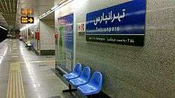
Tehranpars has four main squares called 1st, 2nd, 3rd and 4th falakeh and three metro stations named Shahid Bagheri, Tehran Pars and Farhang Sara. Farhang Sara is the eastern end-station of Tehran Metro network.
Tehranpars was built according to a project in the Pahlavi era in order to keep pace with Tehran's rapid growth. It is surrounded by planted forests of Sorkhe-hesar and Lavizan. The name Tehran Pars literally means "Tehran's Persia".
Some of the Zoroastrian centers of Tehran such as Rostam-bagh and Markar Complex are situated in Tehranpars.
The adjacent neighbourhoods to Tehranpars are Narmak, Qanat Kowsar, Lavizan, Hakimiyeh, Khak-sefid, Majidiyeh, Shahrak-e Omid.
Coordinates: 35°45′N 51°32′E / 35.750°N 51.533°E