Te Kopuru
| Te Kopuru | |
|---|---|
 Te Kopuru | |
| Coordinates: 36°1′55″S 173°55′5″E / 36.03194°S 173.91806°ECoordinates: 36°1′55″S 173°55′5″E / 36.03194°S 173.91806°E | |
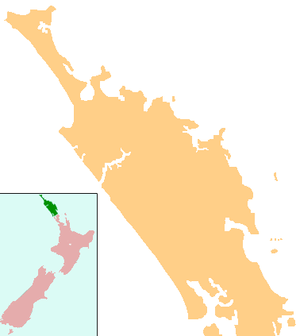
| Country | New Zealand |
| Region | Northland Region |
| District | Kaipara District |
| Population (2006) | |
| • Total | 453 |
Te Kopuru is the largest community on the Pouto Peninsula in Northland, New Zealand. The Wairoa River separates the peninsula at this point from the main North Auckland Peninsula to the east. Dargaville is 14 km (8.7 mi) to the north.[1][2]
The population was 453 in the 2006 Census, a decrease of 27 from 2001.[3]
History
The area was initially occupied by Ngāti Awa, but the Ngāti Whātua displaced them in the late 17th or early 18th century.[4] During the Musket Wars of the early 19th century, fighting between Ngā Puhi and Ngati Whatua and the effects of influenza substantially depopulated the area.[5] In 1841, a skull found on a Pakeha farmer's land infuriated local Māori, who attacked and plundered his farm. A court exonerated the farmer and Māori agreed to sell land at Te Kopuru to the Crown as compensation.[6][7] A hui held at Te Kopuru in 1860 to make peace between Ngāti Whātua and Ngā Puhi was attended by about 600 people.[8]
An attempt to set up a kauri sawmill at Te Kopuru began in 1867, but the machinery was damaged because the ship was leaky, and the owners refused its delivery.[9] The mill was completed in 1870, and began operating the following year. The mill was the largest in New Zealand, producing 120,000 feet (37,000 m) of timber per week in 1875. It was destroyed by fire in 1883, but rebuilt, and rebuilt again after another fire in 1906[10] The town had a stable population of about 215 by the end of the decade.[11] By 1876, the town had stores which were "fitted up in first-rate style, and [were] well-stocked" and a library, but no hotel.[12] A Post Office opened in 1877.[13] In 1878, the town was described as like the "port of some thriving inland city". A steamer service provided transport to Dargaville and Helensville twice a week from February 1878,[14] and a road to Dargaville opened in 1879.[15]
The population increased to 440 during the 1890s as the timber industry grew. A road was built south to Tikinui in 1897, and partially metalled the following year.[16] A library was built in 1899.[17] Gum-diggers were active in the area in the 1890s through at least 1910,[18] and around the turn of the century W Brown and Sons established a boat building yard at Te Kopuru. Dairy herds became established in the early 20th century,[19] In 1903, the Customs Office was moved to Te Kopuru from Pouto.[20] A hospital was built to treat the accident victims from Te Kopuru, Aratapu and Tatarariki, with Te Kopuru as the hospital site rather than Dargaville because the mill towns had a larger population.[21]
The first sealed road in the Kaipara District was probably the one from Te Kopuru to Mount Wesley, just south of Dargaville, in about 1918. The mill closed in 1920. Having a hospital sustained the town. The road north degraded to a metalled road by the 1930s.[22] In 1956, the general wards of Te Kopuru Hospital moved to the new hospital in Dargaville. Maternity and services for the elderly continued, although the main hospital building burned down in 1959. In 1971, the hospital closed with maternity services moved to the Dargaville Hospital.[23]
Notable people
- John Carter, politician
- Jane Goulding, member of the New Zealand field hockey team at the 1984 Summer Olympics.
- Ross Meurant, politician and policeman.
- Clem Simich, politician
- Lana Searle, National broadcaster[24]
- Lawrence Weathers, recipient of the Victoria Cross during the First World War.
- Clifton Webb, politician
- Kendrick Smithyman poet[25]
- Cyril Elliott, soldier, subject of Nice Day for a War: Adventures of a Kiwi Soldier in WWI. 2012 NZ Post Children's Book of the Year.[26]
Education
Te Kopuru School is a coeducational full primary (years 1-8) school with a decile rating of 2 and a roll of 153.[27] The school was founded in 1872. In 1937, the primary schools in Tikinui, Tatarariki and Redhill consolidated into Te Kopuru School.[28]
Aratapu District High School, a little to the north of Te Kopuru, closed in 1965. The nearest secondary school is now in Dargaville.[29]
Notes
- ↑ Peter Dowling (editor) (2004). Reed New Zealand Atlas. Reed Books. pp. map 7. ISBN 0-7900-0952-8.
- ↑ Roger Smith, GeographX (2005). The Geographic Atlas of New Zealand. Robbie Burton. pp. map 26. ISBN 1-877333-20-4.
- ↑ Quickstats about Te Kopuru
- ↑ Byrne, Brian (2002). The Unknown Kaipara. pp. 4–6. ISBN 0-473-08831-2.
- ↑ Byrne, pp 12, 37
- ↑ Ryburn, Wayne (1999). Tall Spars, Steamers & Gum. p. 12. ISBN 0-473-06176-7.
- ↑ Byrne, pp 453-62
- ↑ Byrne, p 425
- ↑ Bradley, Edgar Kelsby (1982). The Great Northern Wairoa. p. 48.
- ↑ Ryburn, p 25, 107-8
- ↑ Ryburn, p 48
- ↑ Byrne, pp 507-8, quoting from an account in the Southern Cross of April 1876
- ↑ Bradley, p 50
- ↑ Ryburn, pp 56-57, 75
- ↑ Bradley, p 54
- ↑ Ryburn, pp 62, 93
- ↑ Bradley, p 51
- ↑ Ryburn, pp 132, 201
- ↑ Ryburn, pp 136, 160
- ↑ Ryburn, p 140
- ↑ Pratt, Ivy Beatrice (1992). The History of the Te Kopuru Hospital, 1903-1971. p. 4.
- ↑ Ryburn, p 166, 192
- ↑ Pratt, p 116-7, 118
- ↑ Stirling, Rose (2 March 2011). "Dealing with the Carnage". Dargaville & Districts News.
- ↑ Dictionary of New Zealand Biography
- ↑ O'Neill, Rachel (March 2012). "Five Easy Questions with Matt Elliott". New Zealand Book Council.
- ↑ Te Kete Ipurangi schools database: Te Kopuru School
- ↑ Ryburn, pp 168, 222
- ↑ Bradley, p 44
External links
- Welcome to Te Kopuru
- Te Kopuru in the Cyclopedia of New Zealand, 1902