Tartus Governorate
| Tartus Governorate مُحافظة طرطوس | |
|---|---|
| Governorate | |
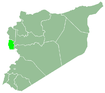
.svg.png) Map of Syria with Tartous highlighted | |
| Coordinates (Tartous): 35°N 36°E / 35°N 36°ECoordinates: 35°N 36°E / 35°N 36°E | |
| Country |
|
| Capital | Tartous |
| Manatiq (Districts) | 5 |
| Government | |
| • Governor | Safwan Abu Sa'adi |
| Area | |
| • Total | 1,892 km2 (731 sq mi) |
| Estimates range between 1,890 km² and 1,892 km² | |
| Population (2014) | |
| • Total | 750,000 |
| • Density | 400/km2 (1,000/sq mi) |
| Time zone | EET (UTC+2) |
| • Summer (DST) | EEST (UTC+3) |
| ISO 3166 code | SY-TA |
| Main language(s) | Arabic |
Tartus Governorate (Arabic: مُحافظة طرطوس / ALA-LC: Muḥāfaẓat Ṭarṭūs) is one of the fourteen governorates (provinces) of Syria. It is situated in western Syria, bordering Lebanon to the south, the Mediterranean Sea to the west, Latakia Governorate to the north, and Homs and Hama Governorates to the east. It is one of the few governorates in Syria that has an Alawite majority. Sources list the area as 1,890 km²[1] or 1,892 km².[2] The governorate has a population of 785,000 (2010 estimate). The capital is Tartus.
History
The governorate was historically part of the Alawite State, which existed from 1920–1936.
The region has been relatively peaceful during the Syrian civil war that started in 2011. However, in May 2013, unverified sources suggest that government forces committed massacres at the villages of Bayda and Baniyas.
Districts
The governorate is divided into five districts (manatiq):
These are further divided into 27 sub-districts (nawahi).
References
External links
- etartus The First Complete website for Tartus news and services
- http://www.tartous-city.com
Capital: Tartus | ||||||||
|  | |||||||
|
| ||||||||
| ||||||||
| ||||||||