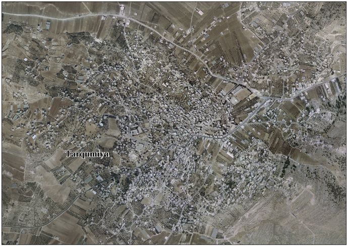
Tarqumiyah
| Tarqumiyah | |
|---|---|
| Other transcription(s) | |
| • Arabic | ترقوميا |
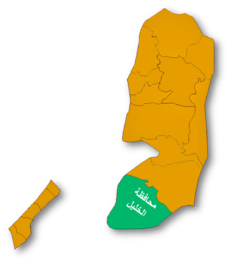
 Tarqumiyah Location of Tarqumiyah within the Palestinian territories | |
| Coordinates: 31°34′30″N 35°00′47″E / 31.57500°N 35.01306°ECoordinates: 31°34′30″N 35°00′47″E / 31.57500°N 35.01306°E | |
| Palestine grid | 151/109 |
| Governorate | Hebron |
| Government | |
| • Type | City |
| Population (2007) | |
| • Jurisdiction | 14,357 |
| Name meaning | Tricomia[1] |
Tarqumiyah (Arabic: ترقوميا) is a Palestinian town located twelve kilometers northwest of Hebron. The town is in the Hebron Governorate Southern West Bank.
History
Tarqumiyah is an ancient town situated on a rocky hill. Cisterns have been found here.[2] According to the Palestine Exploration Fund's Survey of Western Palestine (SWP), this place is the early Christian Tricomias, an episcopal see.[3]
Ottoman era
Tarqumiya, like the rest of Palestine, was incorporated into the Ottoman Empire in 1517, and in the census of 1596 the village appeared to be in the Nahiya of Halil of the Liwa of Quds. It had a population of 17 families, all Muslim. They paid a fixed tax-rate of 33,33 % on agricultural products, including wheat, barley, olive trees, goats and beehives, in addition to occasional revenues; a total of 6,500 Akçe.[4]
In 1838 Edward Robinson passed by and noted that Tarqumiya was on the most common path from Gaza, via Bayt Jibrin to Hebron. While resting at Tarqumiya, he was visited by the local Sheikh and other dignitaries, who “demeaned themselves kindly and courteously."[5][6]
In 1863 Victor Guérin found it to have 400 inhabitants,[7] while an Ottoman village list from about 1870 counted 45 houses and a population of 108, though the population count included men only.[8]
In 1883 SWP described Tarqumiyah as “A small village on a rocky hill near the low lands. On the east, about a mile distant, is a spring; on the south are olives.”[3]
British Mandate era
According to a census conducted in 1922 by the British Mandate authorities, Tarqumiyah had a population of 976 inhabitants, all Muslims,[9] increasing in the 1931 census to 1,173, still entirely Muslim, in 225 inhabited houses.[10]
In 1945 the population of Tarqumiya was 1,550 Muslims, and the total land area was 21,188 dunams of land according to an official land and population survey.[11][12] 1,029 dunams were plantations and irrigable land, 6,614 were used for cereals,[13] while 152 dunams were built-up (urban) land.[14]
1948-1967
In the wake of the 1948 Arab–Israeli War, and after the 1949 Armistice Agreements, Tarqumiyah came under Jordanian rule.
Post-1967
Since the Six-Day War in 1967, Tarqumiyah has been under Israeli occupation. The population in the 1967 census conducted by the Israeli authorities was 2,412.[15] According to the Palestinian Central Bureau of Statistics, the town had a population of over 14,357 in 2007.[16]
Footnotes
- ↑ Palmer, 1881, p. 408
- ↑ Dauphin, 1998, p. 938
- 1 2 Conder and Kitchener, 1883, SWP III, p. 310
- ↑ Hütteroth and Abdulfattah, 1977, p. 123
- ↑ Robinson and Smith, 1841, vol 2, p. 399
- ↑ Robinson and Smith, 1841, vol 3, pp. 11-12
- ↑ Guérin, 1869, p. 345
- ↑ Socin, 1879, p. 162
- ↑ Barron, 1923, p. 10
- ↑ Mills, 1932, p. 34
- ↑ Department of Statistics, 1945, p. 23
- ↑ Government of Palestine, Department of Statistics. Village Statistics, April, 1945. Quoted in Hadawi, 1970, p. 50
- ↑ Government of Palestine, Department of Statistics. Village Statistics, April, 1945. Quoted in Hadawi, 1970, p. 94
- ↑ Government of Palestine, Department of Statistics. Village Statistics, April, 1945. Quoted in Hadawi, 1970, p. 144
- ↑ Perlmann, Joel (November 2011 – February 2012). "The 1967 Census of the West Bank and Gaza Strip: A Digitized Version" (PDF). Levy Economics Institute. Retrieved 24 June 2016.
- ↑ 2007 PCBS Census Palestinian Central Bureau of Statistics. p.118.
Bibliography
- Barron, J. B., ed. (1923). Palestine: Report and General Abstracts of the Census of 1922. Government of Palestine.
- Dauphin, Claudine (1998). La Palestine byzantine, Peuplement et Populations. BAR International Series 726 (in French). III : Catalogue. Oxford: Archeopress. ISBN 0-860549-05-4.
- Conder, Claude Reignier; Kitchener, H. H. (1883). The Survey of Western Palestine: Memoirs of the Topography, Orography, Hydrography, and Archaeology. 3. London: Committee of the Palestine Exploration Fund.
- Department of Statistics (1945). Village Statistics, April, 1945. Government of Palestine.
- Guérin, Victor (1869). Description Géographique Historique et Archéologique de la Palestine (in French). 1: Judee, pt. 3. Paris: L'Imprimerie Nationale.
- Hadawi, Sami (1970). Village Statistics of 1945: A Classification of Land and Area ownership in Palestine. Palestine Liberation Organization Research Center.
- Hütteroth, Wolf-Dieter; Abdulfattah, Kamal (1977). Historical Geography of Palestine, Transjordan and Southern Syria in the Late 16th Century. Erlanger Geographische Arbeiten, Sonderband 5. Erlangen, Germany: Vorstand der Fränkischen Geographischen Gesellschaft. ISBN 3-920405-41-2.
- Mills, E., ed. (1932). Census of Palestine 1931. Population of Villages, Towns and Administrative Areas. Jerusalem: Government of Palestine.
- Palmer, E. H. (1881). The Survey of Western Palestine: Arabic and English Name Lists Collected During the Survey by Lieutenants Conder and Kitchener, R. E. Transliterated and Explained by E.H. Palmer. Committee of the Palestine Exploration Fund.
- Robinson, Edward; Smith, Eli (1841). Biblical Researches in Palestine, Mount Sinai and Arabia Petraea: A Journal of Travels in the year 1838. 2. Boston: Crocker & Brewster.
- Robinson, Edward; Smith, Eli (1841). Biblical Researches in Palestine, Mount Sinai and Arabia Petraea: A Journal of Travels in the year 1838. 3. Boston: Crocker & Brewster.
- Socin, A. (1879). "Alphabetisches Verzeichniss von Ortschaften des Paschalik Jerusalem". Zeitschrift des Deutschen Palästina-Vereins. 2: 135–163.
External links
- Welcome To Tarqumiya
- Survey of Western Palestine, Map 21: IAA, Wikimedia commons
- Tarqumiya Town (fact sheet)
- Tarqumiya Town Profile
- Tarqumiya - aerial photo
- The priorities and needs for development in Tarqumiya town based on the community and local authorities' assessment
| Cities |
|  |
|---|---|---|
| Towns |
| |
| Villages |
| |
| Refugee camps | ||