Tarakeswar
| Tarakeswar তারকেশ্বর तारकेश्वर | |
|---|---|
| Town | |
|
Baba taraknathtemple of Tarakeshwar | |
 Tarakeswar  Tarakeswar Location in West Bengal, India | |
| Coordinates: 22°53′N 88°01′E / 22.89°N 88.02°ECoordinates: 22°53′N 88°01′E / 22.89°N 88.02°E | |
| Country |
|
| State | West Bengal |
| District | Hoogly |
| Elevation | 18 m (59 ft) |
| Population (2011)[1] | |
| • Total | 30,947 |
| Languages | |
| • Official | Bengali, English |
| Time zone | IST (UTC+5:30) |
| Telephone code | 91 3212 |
| Lok Sabha constituency | Arambag |
| Vidhan Sabha constituency | Tarakeswar |
| Website |
wb |

Tarakeswar (pronounced Tarokeshshor) is a town and a municipality in Hooghly District in the Indian state of West Bengal. It is also one of the police stations under Chandannagar subdivision.[2] Tarakeswar is a place of pilgrimage and a centre of the Shaiva sect in West Bengal. 58 kilometres (36 mi) away from Kolkata, Tarakeswar can be reached conveniently by train.
Geography
Tarakeswar is located at 22°53′N 88°01′E / 22.89°N 88.02°E. It has an average elevation of 18 metres (59 feet). It is in the Chandannagore sub-division in Hooghly District of Burdwan Division in the state of West Bengal. It is situated in the middle part of the Hooghly District . The Town is connected both by railway and State Highway.The Town is 48 km. From Chinsurah, the District Headquater and 45 km from Chandannagore, the Sub-Divisional Headquarter and 58 km from Kolkata, the State Capital by railway (BG) .It is also connected with other urban centers of District with motorable roads.
Demographics
As per 2011 Census of India Tarakeswar had a total population of 30,947 of which 16,049 (52%) were males and 14,898 (48%) were females. Population below 6 years was 2,685. The total number of literates in Tarakeswar was 23,711 (83.90% of the population over 6 years).[3]
As of 2001 India census,[4] Tarakeswar had a population of 28,178. Males constitute 53% of the population (i.e., 14,986) and females 47% (i.e., 13,192). The Sex ratio (i.e. number of female per 1000 males) of population is 880. In Tarakeswar, 10% of the population is under 6 years of age. The gross density of population is 7262 person per Sq.km. Tarakeswar has an average literacy rate of 72%, higher than the national average of 59.5%: male literacy is 78%, and female literacy is 66%.
Area and Administrative boundary
At present the area of the town is 3.88Sq km. The Municipal area is divided into 15 No. wards for administrative purpose. Tarakeswar town is situated in the center of Tarakeswar Block . Four Gram Panchayet surround this Municipality . North portion of this town is Bhanjipur Gram Panchayat, south portion is Ramnagar Gram Panchayet, east portion is Baligori (1) Gram Panchayet and west portion is Sontoshpur Gram Panchayat.
Administrative set up
The Tarakeswar is in the Chandannagore Sub-Division under the Burdwan Division in the District of Hooghly. It is also under the Tarakeswar Police Station and Tarakeswar Block Development Office. The town came the status of Municipality on 6 August 1975 .
Out of a total population of 30,947 , 93.22% were Hindu, 4.97% were Muslim while other religions and atheism comprised the rest.[5]
Economics
Main occupation of the town is Agriculture.Trade & Commerce also play an important role.
Taraknath Temple
Pilgrims visit the Taraknath Temple throughout the year, especially on Mondays. Thousands of pilgrims visit Tarakeswar on the occasions of Shivaratri, month of July–August (Srabon in Bengali calendar) and Gajan.
Taraknath Temple is a famous hindu shrine located in the town of Tarakeswar in Hooghly district of West Bengal, India. The temple enshrines a Shayambhu linga of Lord Shiva. The temple is believed to be constructed in 1729 AD by Raja Bharamalla.
Taraknath Mandir was built in an ‘Atchala’ structure of Bengal temple architecture with a ‘natmandir’ in front. The temple features four roofs above the sanctum sanctorum and extended galleries for the congregation of the devotees. Dudhpukur tank, located north of the temple, is believed to fulfill the prayers of those taking a dip in it. The temple is also claimed to be one of the Jyothirlinga shrines of Mahadev.
Education
The town has 3 Higher Secondary Schools, 1 Secondary School, 14 primary schools out of which six are Govt. sanctioned and 8 private school. There are also one college, 3 Shishu Shikha Centre, 2 Branch centers of Open University and Open School and, one Vocational Education & Training Centre. Primary schools in the town are Vidyamandir, Girindra Prathamik Vidyalaya, Hindi School, Anandamarg Primary School, Ramkrishna Vidyamandir, Sishu Niketan, Ankur, Bhanjipur SSK, Children's Aim, Scarlet Academy, Sahapur Primary School. The high schools are Tarakeswar High School (Boys), Tarkeswar Girls' School, Bikash Bharati Blooms Day School, Kendriya Vidyalaya, and Tarakeswar Mahavidyalaya. Tarakeswar Degree College, affiliated to Burdwan University, is the only college in Tarakeswar.
Transport
ROAD TRANSPORTATION:
The town has got about 45.493 KM road out of which 13.436 KM. is Bituminous Road, 10.483 KM is Concrete road, 11.801 KM is Brick pavement, 1.857 KM is Bats-Moorum roads and 7.914 KM Kancha Road.
RAILWAY TRANSPORTATION:
The town has got a status of Model Station of Eastern Railway. The distance between Howrah and Tarakeswar is 58 KM . It has already situated as a transportation center for potato and other green vegetables in South Bengal.
The Howrah-Tarakeswar line was opened in 1885.[6] Tarakeswar railway station was also a terminal for the Bengal Provincial Railway. It is part of the Kolkata Suburban Railway system.[7] Tarakeswar Railway Station is declared as a Multifunctional Station. The present Railway Line between Sheoraphuli railway station and Tarakeswar has been extended to Bishnupur in Bankura via Arambagh. Tarakeswar Railway station Enquiry: 03212276190.
Communication
Champadanga area Telephone Exchange with Dialling code 03212 serves: Begampur, Bhagabatipur, Champadanga, Chanditala, Dihi-batpur, Dwarhatta, Piyasara, Gopinagar, Haripal, Harinkhola, Jangipara, Jinpur, Dulalbati, Mashat, Nalikul, Rajbalahat, Shaympur, Pratiharpur, Loknath, Tarakeswar, Talpur, Taukipur and Mayapur.[8]
See also
- Tarakeswar affair
- Tarakeswar Municipality, Hugli, West Bengal
- Taraknath Temple, Tarakeswar, West Bengal
References
- ↑ http://www.censusindia.gov.in/pca/SearchDetails.aspx?Id=343377
- ↑ District-wise list of statutory towns
- ↑ "2011 Census – Primary Census Abstract Data Tables". West Bengal – District-wise. Registrar General and Census Commissioner, India. Retrieved 15 June 2016.
- ↑ "Census of India 2001: Data from the 2001 Census, including cities, villages and towns (Provisional)". Census Commission of India. Archived from the original on 2004-06-16. Retrieved 2008-11-01.
- ↑ "Tarakeswar City Population Census 2011 - West Bengal". www.census2011.co.in. Retrieved 2016-11-21.
- ↑ Chaudhuri, Sukanta, The Railway Comes to Calcutta, in Calcutta, the Living City, Vol. I, edited by Sukanta Chaudhuri, p. 239, Oxford University Press, ISBN 978-0-19-563696-3.
- ↑ http://erail.in?T=TAK::HWH:
- ↑ "Adjacent Area Dialling Schemes". BSNL. Retrieved 2009-01-29.
Cities, towns and locations in Hooghly District | |||||||||||||||
|---|---|---|---|---|---|---|---|---|---|---|---|---|---|---|---|
| Cities, municipal and census towns |
| ||||||||||||||
| Locations other than cities and towns | |||||||||||||||
| Related topics |
| ||||||||||||||
| Bankura | 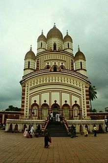 | |
|---|---|---|
| Bardhaman |
| |
| Birbhum |
| |
| Hooghly | ||
| Howrah | ||
| Jalpaiguri | ||
| Kolkata | ||
| Nadia |
| |
| North 24 Parganas |
| |
| Medinipur | ||
| Centres | ||
9. http://tarakeswarmunicipality.in/site/index.php